Leal, North Dakota

Last updated
Leal, North Dakota
Leal, North Dakota.jpg
Grain elevators in Leal
ND Barnes County Leal.svg
Location of Leal, North Dakota
USA North Dakota location map.svg
Red pog.svg
Leal, North Dakota
Coordinates: 47°6′20″N98°18′59″W / 47.10556°N 98.31639°W / 47.10556; -98.31639 Coordinates: 47°6′20″N98°18′59″W / 47.10556°N 98.31639°W / 47.10556; -98.31639
CountryUnited States
State North Dakota
County Barnes
Founded1892
Incorporated (village)1917
Incorporated (city)1967
Named for Scottish for "faithful"
Government
[1]
  Type Mayor-Council
  MayorDave Lokken
Area
[2]
  Total0.13 sq mi (0.33 km2)
  Land0.13 sq mi (0.33 km2)
  Water0.00 sq mi (0.00 km2)
Elevation
1,467 ft (447 m)
Population
 (2020)
  Total27
  Density209.30/sq mi (80.87/km2)
Time zone UTC-6 (CST)
  Summer (DST) UTC-5 (CDT)
ZIP code
58479
Area code 701
FIPS code 38-45460
GNIS feature ID 1029852 [3]

Leal is a city in Barnes County in the state of North Dakota. The population was 27 at the 2020 census. [4] Leal was founded in 1892. The name comes from the Scots word for "faithful," which in the phrase laund o the leal means Heaven. [5]

Contents

History

Bell display outside a park in Leal, listing the year of the city's founding "1892" Park in Leal, North Dakota.jpg
Bell display outside a park in Leal, listing the year of the city's founding "1892"

Scottish-English emigrants from Ontario, Canada, originally settled in this area in 1883. The townsite of Leal was platted in 1892, and a post office established December 28, 1892. Officials with the Soo Line Railroad established a station here in 1902. [5] [6]

Leal incorporated as a village in 1917 from part of Edna Township. [7] It became a city in 1967, after the North Dakota Legislature eliminated incorporation titles for villages and towns. As a result, all incorporated municipalities in North Dakota automatically adopted a city form of government. [8]

Geography

Leal is located in Edna Township in the northeastern part of Barnes County. It is 73 miles (117 km) west of Fargo, and the nearest city is Rogers. [9]

According to the United States Census Bureau, the city has a total area of 0.14 square miles (0.36 km2), all land. [10]

Climate

Due to its location in the Great Plains and distance from both mountains and oceans, the city has an extreme continental climate, USDA Plant Hardiness Zone 4. The lowest temperature ever recorded was −37 °F (−38 °C) on December 23, 1983, and the highest temperature ever recorded was 106 °F (41 °C) on July 30, 2006. [11]

Demographics

Historical population
CensusPop.
1920 88
1930 10519.3%
1940 102−2.9%
1950 72−29.4%
1960 70−2.8%
1970 41−41.4%
1980 459.8%
1990 35−22.2%
2000 362.9%
2010 20−44.4%
2020 2735.0%
2021 (est.)24 [12] −11.1%
U.S. Decennial Census [13]
2020 Census [4]

2010 census

As of the census of 2010, there were 20 people, 10 households, and 6 families residing in the city. The population density was 142.9 inhabitants per square mile (55.2/km2). There were 11 housing units at an average density of 78.6 per square mile (30.3/km2). The racial makeup of the city was 95.0% White and 5.0% from two or more races.

There were 10 households, of which 10.0% had children under the age of 18 living with them, 40.0% were married couples living together, 20.0% had a female householder with no husband present, and 40.0% were non-families. 40.0% of all households were made up of individuals, and 10% had someone living alone who was 65 years of age or older. The average household size was 2.00 and the average family size was 2.50.

The median age in the city was 53 years. 15% of residents were under the age of 18; 10% were between the ages of 18 and 24; 15% were from 25 to 44; 45% were from 45 to 64; and 15% were 65 years of age or older. The gender makeup of the city was 35.0% male and 65.0% female.

2000 census

As of the census of 2000, there were 36 people, 12 households, and 11 families residing in the city. The population density was 272.4 inhabitants per square mile (105.2/km2). There were 12 housing units at an average density of 90.8 per square mile (35.1/km2). The racial makeup of the city was 100.00% White. The top 4 ancestry groups in the city are Norwegian (65.5%), German (21.8%), Italian (16.4%), and French (16.4%). 21 residents reported having multiple ancestries, meaning these percentages add up to more than 100% of the population. [14]

There were 12 households, out of which 58.3% had children under the age of 18 living with them, 66.7% were married couples living together, 25.0% had a female householder with no husband present, and 8.3% were non-families. 8.3% of all households were made up of individuals, and 8.3% had someone living alone who was 65 years of age or older. The average household size was 3.00 and the average family size was 3.18.

In the city, the population was spread out, with 38.9% under the age of 18, 5.6% from 18 to 24, 27.8% from 25 to 44, 19.4% from 45 to 64, and 8.3% who were 65 years of age or older. The median age was 34 years. For every 100 females, there were 63.6 males. For every 100 females age 18 and over, there were 83.3 males.

The median income for a household in the city was $28,750, and the median income for a family was $31,875. Males had a median income of $27,188 versus $0 for females. The per capita income for the city was $10,662. About 13.3% of families and 9.1% of the population living below the poverty line, including 13.0% of those under 18 and none of those aged 65 and over.

Climate data for Leal, North Dakota
MonthJanFebMarAprMayJunJulAugSepOctNovDecYear
Average high °F (°C)20
(−7)
25
(−4)
38
(3)
55
(13)
69
(21)
77
(25)
82
(28)
81
(27)
70
(21)
55
(13)
36
(2)
24
(−4)
53
(12)
Average low °F (°C)1
(−17)
7
(−14)
19
(−7)
32
(0)
44
(7)
54
(12)
58
(14)
55
(13)
45
(7)
33
(1)
19
(−7)
7
(−14)
31
(0)
Average precipitation inches (mm)0.56
(14)
0.50
(13)
0.80
(20)
1.26
(32)
2.61
(66)
2.99
(76)
3.15
(80)
2.25
(57)
1.62
(41)
1.36
(35)
0.63
(16)
0.48
(12)
18.21
(462)
Source: MSN.com [11]

Related Research Articles

<span class="mw-page-title-main">Barnes County, North Dakota</span> County in North Dakota, United States

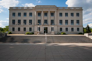
Barnes County is a county in the U.S. state of North Dakota. As of the 2020 census, the population was 10,853. Its county seat is Valley City.

<span class="mw-page-title-main">Reeder, North Dakota</span> City in North Dakota, United States

Reeder is a city in Adams County, North Dakota, United States. The population was 125 at the 2020 census.

<span class="mw-page-title-main">Dazey, North Dakota</span> City in North Dakota, United States

Dazey is a city in Barnes County, North Dakota, United States. The population was 78 at the 2020 census. Dazey was founded in 1883 after a local farmer, Charles Dazey, donated land to start a townsite.

<span class="mw-page-title-main">Landa, North Dakota</span> City in North Dakota, United States

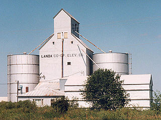
Landa is a city in Bottineau County, North Dakota, United States. The population was 41 at the 2020 census. Landa was founded in 1904.

<span class="mw-page-title-main">Maxbass, North Dakota</span> City in North Dakota, United States

Maxbass is a city in Bottineau County, North Dakota, United States. The population was 89 at the 2020 census. Maxbass was founded in 1905.

<span class="mw-page-title-main">Rhame, North Dakota</span> City in North Dakota, United States

Rhame is a city in Bowman County, North Dakota, United States. The population was 158 at the 2020 census. Rhame was founded in 1908.

<span class="mw-page-title-main">Lincoln, North Dakota</span> City in North Dakota, United States

Lincoln is a city in Burleigh County, North Dakota, United States. It is a suburb of adjacent Bismarck, and also a core city of the Bismarck-Mandan Metropolitan Statistical Area. The population was 4,257 at the 2020 census, making it the fourteenth largest city in North Dakota. Lincoln was founded in 1977.

<span class="mw-page-title-main">Osnabrock, North Dakota</span> City in North Dakota, United States

Osnabrock is a city in Cavalier County, North Dakota, United States. The population was 105 at the 2020 census. Osnabrock was founded in 1882 and incorporated as a village in 1903. It was named after Osnabruck, Ontario, the home town of its first postmaster, James T. Anderson.

<span class="mw-page-title-main">Dodge, North Dakota</span> City in North Dakota, United States

Dodge is a city in Dunn County, North Dakota, United States. The population was 89 at the 2020 census. Dodge was founded in 1915.

<span class="mw-page-title-main">Halliday, North Dakota</span> City in North Dakota, United States

Halliday is a city in Dunn County, North Dakota, United States. The population was 241 at the 2020 census. Halliday was founded in 1914.

<span class="mw-page-title-main">Killdeer, North Dakota</span> City in North Dakota, United States

Killdeer is a city in Dunn County, North Dakota, United States. The population was 939 at the 2020 census.

<span class="mw-page-title-main">Mott, North Dakota</span> City in North Dakota, United States

Mott is a city in Hettinger County, North Dakota, United States. It is the county seat of Hettinger County. The population was 653 at the 2020 census.

<span class="mw-page-title-main">Kief, North Dakota</span> City in North Dakota, United States

Kief is a city in McHenry County, North Dakota, United States. The population was 8 at the 2020 census. It is part of the Minot Micropolitan Statistical Area. Kief was founded in 1908.

<span class="mw-page-title-main">Almont, North Dakota</span> City in North Dakota, United States

Almont is a city in Morton County, North Dakota, United States. It is part of the "Bismarck, ND Metropolitan Statistical Area" or "Bismarck–Mandan". The population was 100 at the 2020 census. Almont was founded in 1906, incorporated in 1936, and reached a peak population of 232 in 1940. The Northern Pacific Railroad tracks were removed in 1947 when the mainline was rerouted, and the city has since withered to just above 100 residents.

<span class="mw-page-title-main">Christine, North Dakota</span> City in North Dakota, United States

Christine is a city in Richland County, North Dakota, United States. The population was 151 at the 2020 census. Christine was founded in 1883. It is part of the Wahpeton, ND–MN Micropolitan Statistical Area.

<span class="mw-page-title-main">Great Bend, North Dakota</span> City in North Dakota, United States

Great Bend is a city in Richland County, North Dakota, United States, on the banks of the Wild Rice River. Its population was 49 at the 2020 census. It was founded in 1888, and incorporated as a village in 1908. It is part of the Wahpeton, ND–MN Micropolitan Statistical Area.

<span class="mw-page-title-main">Cando, North Dakota</span> City in North Dakota, United States

Cando is a city in Towner County, North Dakota, United States. It is the county seat of Towner County. The population was 1,117 at the 2020 census. Cando was founded in 1884.

<span class="mw-page-title-main">Buxton, North Dakota</span> City in North Dakota, United States

Buxton is a city in Traill County, North Dakota, United States. The population was 348 at the 2020 census. Buxton was founded in 1880. Today, it has become a bedroom community for the nearby Greater Grand Forks metropolitan area.

<span class="mw-page-title-main">Sarles, North Dakota</span> City in North Dakota, United States

Sarles is a city in Cavalier and Towner counties in the State of North Dakota. The population was 16 at the 2020 census. Sarles was founded in 1905 at the end of the Great Northern railway extension north of Munich, called the "Sarles Branch". The town is named for North Dakota Governor Elmore Y. Sarles.

<span class="mw-page-title-main">Overly, North Dakota</span> City in North Dakota, United States

Overly is a city in Bottineau County in the U.S. state of North Dakota. The population was 10 at the 2020 census.

References

  1. "Township and City Officers". Barnes County, North Dakota. Archived from the original on August 16, 2009. Retrieved September 22, 2009.
  2. "ArcGIS REST Services Directory". United States Census Bureau. Retrieved September 20, 2022.
  3. "US Board on Geographic Names". United States Geological Survey. October 25, 2007. Retrieved January 31, 2008.
  4. 1 2 "Explore Census Data". United States Census Bureau . Retrieved July 21, 2022.
  5. 1 2 Wick, Douglas A. (1988). North Dakota Place Names. Bismarck, N.D.: Hedemarken Collectibles. p. 111. ISBN   0-9620968-0-6. OCLC   191277027.
  6. Williams, Mary Ann (Barnes) (1966). Origins of North Dakota place names. Bismarck, North Dakota: Bismarck tribune, 1966. p. 14. OCLC   431626.
  7. U.S. Census Bureau (1921). "Number and Distribution of Inhabitants, North Dakota" (PDF). Fourteenth Census of the United States: 1920. Government Printing Office . Retrieved July 20, 2008.
  8. North Dakota Secretary of State (1989). North Dakota Centennial Blue Book. Bismarck, ND: North Dakota Legislative Assembly. p. 500.
  9. "Leal Forks, North Dakota (ND) Detailed Profile". City-Data.com. Retrieved September 22, 2009.
  10. "US Gazetteer files 2010". United States Census Bureau. Archived from the original on July 2, 2012. Retrieved June 14, 2012.
  11. 1 2 "MSN Weather". MSN.com. Archived from the original on June 7, 2007. Retrieved June 5, 2007.
  12. "City and Town Population Totals: 2020-2021". United States Census Bureau. July 21, 2022. Retrieved July 21, 2022.
  13. United States Census Bureau. "Census of Population and Housing" . Retrieved October 31, 2013.
  14. U.S. Census Bureau. Census 2000. "QT-P13. Ancestry, Leal, North Dakota". American FactFinder. <http://factfinder.census.gov>. Retrieved 2009-01-31.