Sanborn, North Dakota

Last updated
Sanborn, North Dakota
ND Barnes County Sanborn.svg
Location of Sanborn, North Dakota
USA North Dakota location map.svg
Red pog.svg
Sanborn, North Dakota
Coordinates: 46°56′33″N98°13′31″W / 46.94250°N 98.22528°W / 46.94250; -98.22528
CountryUnited States
State North Dakota
County Barnes
Founded1879
Area
[1]
  Total0.60 sq mi (1.55 km2)
  Land0.60 sq mi (1.55 km2)
  Water0.00 sq mi (0.00 km2)
Elevation
1,450 ft (442 m)
Population
 (2020)
  Total161
  Density268.33/sq mi (103.66/km2)
Time zone UTC-6 (CST)
  Summer (DST) UTC-5 (CDT)
ZIP code
58480
Area code 701
FIPS code 38-70380
GNIS feature ID1031334 [2]

Sanborn is a city in Barnes County, North Dakota, United States. The population was 161 at the 2020 census. [3] Sanborn was founded in 1879.

Contents

History

A post office has been in operation at Sanborn since 1879. [4] The city was named in honor of J. N. Sanborn, an early settler. The town was an early contender for the county seat of Barnes County, but lost this role to Valley City in 1880. [5] Its population declined after better roads allowed nearby farmers to trade in Valley City instead. [6]

Geography

Sanborn is located at 46°56′33″N98°13′31″W / 46.94250°N 98.22528°W / 46.94250; -98.22528 (46.942638, -98.225227). [7]

According to the United States Census Bureau, the city has a total area of 0.55 square miles (1.42 km2), all land. [8]

Demographics

Historical population
CensusPop.Note
1890 227
1900 25914.1%
1910 39050.6%
1920 3910.3%
1930 343−12.3%
1940 3666.7%
1950 324−11.5%
1960 263−18.8%
1970 255−3.0%
1980 237−7.1%
1990 164−30.8%
2000 19418.3%
2010 192−1.0%
2020 161−16.1%
2021 (est.)161 [9] 0.0%
U.S. Decennial Census [10]
2020 Census [3]

2010 census

As of the census of 2010, there were 192 people, 73 households, and 58 families living in the city. The population density was 349.1 inhabitants per square mile (134.8/km2). There were 80 housing units at an average density of 145.5 per square mile (56.2/km2). The racial makeup of the city was 99.0% White and 1.0% from two or more races.

There were 73 households, of which 34.2% had children under the age of 18 living with them, 69.9% were married couples living together, 5.5% had a female householder with no husband present, 4.1% had a male householder with no wife present, and 20.5% were non-families. 15.1% of all households were made up of individuals, and 5.5% had someone living alone who was 65 years of age or older. The average household size was 2.63 and the average family size was 2.93.

The median age in the city was 44 years. 26% of residents were under the age of 18; 5.3% were between the ages of 18 and 24; 21.5% were from 25 to 44; 36% were from 45 to 64; and 11.5% were 65 years of age or older. The gender makeup of the city was 51.0% male and 49.0% female.

2000 census

As of the census of 2000, there were 194 people, 74 households, and 54 families living in the city. The population density was 357.0 inhabitants per square mile (137.8/km2). There were 80 housing units at an average density of 147.2 per square mile (56.8/km2). The racial makeup of the city was 97.94% White, 1.03% African American, 0.52% Native American, and 0.52% from two or more races.

There were 74 households, out of which 36.5% had children under the age of 18 living with them, 63.5% were married couples living together, 9.5% had a female householder with no husband present, and 25.7% were non-families. 20.3% of all households were made up of individuals, and 8.1% had someone living alone who was 65 years of age or older. The average household size was 2.62 and the average family size was 3.07.

In the city, the population was spread out, with 28.4% under the age of 18, 5.7% from 18 to 24, 27.8% from 25 to 44, 26.8% from 45 to 64, and 11.3% who were 65 years of age or older. The median age was 37 years. For every 100 females, there were 84.8 males. For every 100 females age 18 and over, there were 85.3 males.

The median income for a household in the city was $30,417, and the median income for a family was $33,750. Males had a median income of $26,563 versus $19,375 for females. The per capita income for the city was $13,355. None of the families and 2.6% of the population were living below the poverty line, including no under eighteens and 12.8% of those over 64.

Related Research Articles

<span class="mw-page-title-main">Sanborn County, South Dakota</span> County in South Dakota, United States

Sanborn County is a county in the U.S. state of South Dakota. As of the 2020 census, the population was 2,330. Its county seat and largest city is Woonsocket. The county was created by the Dakota Territorial legislature on May 1, 1883, with land partitioned from Miner County. It was fully organized by July 18, 1883.

<span class="mw-page-title-main">Lily Lake, Illinois</span> Village in Illinois, United States

Lily Lake is a small rural village in Kane County, Illinois, United States. The town is 15 miles (24 km) southwest of Elgin and 50 miles (80 km) west of Chicago. The village is in the far western part the Chicago metro area. It was incorporated as a village on November 6, 1990. The population was 1,032 at the 2020 census, up from 993 in 2010.

<span class="mw-page-title-main">Sanborn, Iowa</span> City in Iowa, United States

Sanborn is a city in O'Brien County, Iowa, United States. The population was 1,392 at the time of the 2020 census.

<span class="mw-page-title-main">Melvin, Iowa</span> City in Iowa, United States

Melvin is a city in Osceola County, Iowa, United States. The population was 199 at the time of the 2020 census.

<span class="mw-page-title-main">Barnes, Kansas</span> City in Washington County, Kansas

Barnes is a city in Washington County, Kansas, United States. As of the 2020 census, the population of the city was 165.

<span class="mw-page-title-main">Sanborn, Minnesota</span> City in Minnesota, United States

Sanborn is a city in Redwood County, Minnesota, United States. The population was 339 at the 2010 census.

<span class="mw-page-title-main">Rosendale, Missouri</span> City in Missouri, United States

Rosendale is a city in Andrew County, Missouri, United States. The population was 143 at the 2010 census.

<span class="mw-page-title-main">Linneus, Missouri</span> City in Missouri, United States

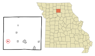
Linneus is a small city in Linn County, Missouri, United States. The population was 281 at the 2020 census. It is the county seat of Linn County.

<span class="mw-page-title-main">Meadville, Missouri</span> City in Missouri, United States

Meadville is a city in southwest Linn County, Missouri, United States. The population was 415 at the 2020 census.

<span class="mw-page-title-main">Nelson, Missouri</span> City in Missouri, United States

Nelson is a city in Saline County, Missouri, United States. The population was 152 at the 2020 census.

<span class="mw-page-title-main">Schell City, Missouri</span> City in Missouri, United States

Schell City is a city in northeast Vernon County, Missouri, United States. The population was 249 at the 2010 census.

<span class="mw-page-title-main">Ronda, North Carolina</span> Town in North Carolina, United States

Ronda is a town in Wilkes County, North Carolina, United States. The population was 417 at the 2010 census, and 413 at the 2020 census. Ronda was named after a nearby estate called "Roundabout", which was the residence of Benjamin Cleveland, a locally prominent planter and a colonel in the North Carolina militia during the Revolutionary War. The town is home to East Wilkes High School, one of Wilkes County's five public high schools.

Shiloh is a census-designated place (CDP) in Harrison Township in Montgomery County, Ohio, United States. It was delineated as a census-designated place at the 2000 census, at which time its population was 11,272. It was not delineated as a CDP at the 2010 census. It is located directly north of the city of Dayton and is part of the Dayton Metropolitan Statistical Area.

<span class="mw-page-title-main">Woodbury, Pennsylvania</span> Borough in Pennsylvania, United States

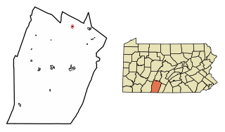
Woodbury is a borough in Bedford County, Pennsylvania, United States. The population was 286 at the 2020 census.

<span class="mw-page-title-main">Milesburg, Pennsylvania</span> Borough in Pennsylvania, United States

Milesburg is a borough in Centre County, Pennsylvania. It is part of the State College, Pennsylvania metropolitan statistical area. The population was 1,093 at the 2020 census.

<span class="mw-page-title-main">Grantley, Pennsylvania</span> CDP in Pennsylvania, United States

Grantley is a census-designated place (CDP) in York County, Pennsylvania, United States. The population was 3,628 at the 2010 census.

<span class="mw-page-title-main">Letcher, South Dakota</span> Town in South Dakota, United States

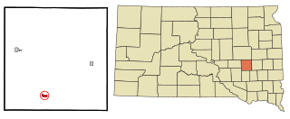
Letcher is a town in Sanborn County, South Dakota, United States. The population was 159 at the 2020 census.

<span class="mw-page-title-main">Woonsocket, South Dakota</span> City in South Dakota, United States

Woonsocket is a city in Sanborn County, South Dakota. The population was 631 at the 2020 census. It is the county seat of Sanborn County.

<span class="mw-page-title-main">Barnes City, Iowa</span> City in Iowa, United States

Barnes City is a city in Mahaska and Poweshiek counties in the U.S. state of Iowa. The population was 156 at the 2020 census.

<span class="mw-page-title-main">Niagara, Wisconsin</span> City in Wisconsin, United States

Niagara is a city in Marinette County, Wisconsin, United States. The population was 1,624 at the 2010 census. The city lies to the north of and adjacent to the Town of Niagara. It is part of the Marinette, WI–MI Micropolitan Statistical Area.

References

  1. "ArcGIS REST Services Directory". United States Census Bureau. Retrieved September 20, 2022.
  2. "US Board on Geographic Names". United States Geological Survey. October 25, 2007. Retrieved January 31, 2008.
  3. 1 2 "Explore Census Data". United States Census Bureau . Retrieved July 17, 2022.
  4. "Barnes County". Jim Forte Postal History. Retrieved October 22, 2015.
  5. Federal Writers' Project (1938). North Dakota, a Guide to the Northern Prairie State. WPA. p. 281. ISBN   978-1-62376-033-5.
  6. "Barnes County History 1976: Sanborn". p. 288.
  7. "US Gazetteer files: 2010, 2000, and 1990". United States Census Bureau. February 12, 2011. Retrieved April 23, 2011.
  8. "US Gazetteer files 2010". United States Census Bureau. Archived from the original on January 25, 2012. Retrieved June 14, 2012.
  9. "City and Town Population Totals: 2020-2021". United States Census Bureau. July 17, 2022. Retrieved July 17, 2022.
  10. United States Census Bureau. "Census of Population and Housing" . Retrieved October 31, 2013.