Peakhurst, New South Wales

Last updated

Peakhurst
Sydney,  New South Wales
Peakhurst Inn.jpg
Peakhurst Inn, Forest Road
Peakhurst, New South Wales
Population10,539 (2016 census) [1]
Established1840
Postcode(s) 2210
Location21 km (13 mi) south of Sydney CBD
LGA(s) Georges River Council
State electorate(s) Oatley
Federal Division(s) Banks
Suburbs around Peakhurst:
Riverwood Riverwood Hurstville
Padstow Peakhurst Mortdale
Padstow Heights Lugarno Peakhurst Heights

Peakhurst is a suburb in Southern Sydney, or the St George Area, in the state of New South Wales, Australia 21 kilometres south of the Sydney central business district. Peakhurst is in the local government area of the Georges River Council.

Contents

Peakhurst has a western border on Salt Pan Creek, on the Georges River. Peakhurst Heights is a separate suburb to the south, which is bordered by Boggywell Creek and Lime Kiln Bay, on the Georges River. Peakhurst Heights is sometimes still considered to be part of 'Peakhurst' by some residents of the area.

History

Peakhurst was named after landholder John Robert Peake, who bought 10 acres of land near the junction of the present Forest Road and Henry Lawson Drive in 1838. He gave a block of land on which the Wesleyan Church was built in 1855. [2]

The area was originally part of an 1808 land grant to Captain John Townson. [2] John Robert Peake bought his land from William Hebblewhite in 1838. School Inspector Huffer suggested that Peake's name be used to name the suburb when the public school was founded in 1871. The post office opened in 1885. [2]

The first industry in the area was timber-cutting, due to the surrounding natural forests being thick with a variety of woods, especially turpentine. The timber was carted to Sydney by bullock teams. As the land was cleared, orchardists followed the timber-cutters. [2]

Commercial area

Peakhurst's commercial centres are predominantly located along Forest Road and Boundary Road. Various retail shops, restaurants and cafes are located near the Peakhurst Inn Hotel on Forest Road. The hotel contains a pub and drive-through bottle shop. Peakhurst also contains a sizeable industrial area mainly on and around Boundary Road.

Transport

The main roads are Forest Road, Henry Lawson Drive, Stoney Creek Road, Boundary Road, Bonds Road, Broad Arrow Road, Isaac Street, Baumans Road. Forest Road, which links to Henry Lawson Drive at Peakhurst, is the busiest carriageway that extends through numerous other suburbs in Sydney.

Buses operate through Peakhurst.

St Abraam and St Mikhail Al-Behairy Coptic Orthodox Church Peakhurst church.JPG
St Abraam and St Mikhail Al-Behairy Coptic Orthodox Church

Schools

There are four public schools: Georges River College Peakhurst Campus, Peakhurst Public School, Peakhurst South Public School, [3] Peakhurst West Public School.

Churches

Georges River Life Church, Church@thepeak Anglican Church, Our Lady of Fatima Catholic Church, St Abraam and St Mikhail Al-Behairy Coptic Orthodox Church, Peakhurst Uniting Church, Spanish Evangelical Jerusalem Baptist Church, Samoan Assembly of God Church.

Sport and recreation

Popular recreational venues include Grandviews Bowling Club (lawn bowls), tennis courts, Peakhurst Park and the numerous sporting fields located at Gannon's Park. The soccer clubs here are Peakhurst United and Forest Rangers.

Population

Demographics

According to the 2006 Australian Bureau of Statistics Census of Population, there were 9,113 people usually resident in Peakhurst. 23.4% stated they were born overseas with the top countries of birth being China 2.9%, United Kingdom 2.7% and Republic of Macedonia 1.4%. English was stated as the only language spoken at home by 70% of residents and the most common other languages spoken were Arabic 4.9%, Greek 4.6% and Cantonese 3.6%. The most common responses for religious affiliation were Catholic 28.1%, Anglican 21.6% and Orthodox 10.1%. [4]

Notable residents

Politics

The City of Hurstville local government area which administers Peakhurst, consists of 12 councillors elected every four years. Peakhurst falls into two Wards of the city: Peakhurst Ward and Penshurst Ward. A further five suburbs are contained wholly or partly in the Peakhurst Ward: Riverwood, Mortdale, Oatley, Lugarno and Peakhurst Heights.

Environment

An audit of the environmental impact of the industrial area was commenced in September 2002. [11] Bushcare volunteers help preserve remnant pockets of native forestation. A very small number of fresh water watercourses exist in the suburb, mostly draining into Salt Pan Creek. A portion of the Peakhurst tree population was included in the 1990 National Trust Lugarno Tree Study. [12]

Related Research Articles

Beverly Hills, New South Wales Suburb of Sydney, New South Wales, Australia

Beverly Hills is a southern suburb of Sydney, in the state of New South Wales, Australia. Beverly Hills is located 15 kilometres southwest of the Sydney central business district and is part of the St George area and is split between the local government areas of the Georges River Council and the City of Canterbury-Bankstown. It is often colloquially referred to as "Bevo". The postcode is 2209, which it shares with neighbouring Narwee.

Hurstville, New South Wales Suburb of Sydney, New South Wales, Australia

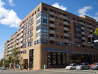
Hurstville is a suburb in Southern Sydney, New South Wales, Australia. It is 16 kilometres south of the Sydney CBD and is part of the St George area. Hurstville is the administrative centre of the local government area of the Georges River Council.

Oatley, New South Wales Suburb of Sydney, New South Wales, Australia

Oatley is a suburb in Southern Sydney in the state of New South Wales, Australia. It is located 18 kilometres south of the Sydney central business district and is part of the St George area. Oatley lies in the local government area of Georges River Council. It lies on the northern side of the tidal estuary of the Georges River and its foreshore includes part of Oatley Bay and Lime Kiln Bay, and all of Neverfail Bay, Gungah Bay and Jewfish Bay.

Division of Banks Australian federal electoral division

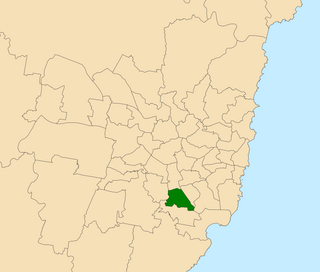
The Division of Banks is an Australian electoral division in the state of New South Wales.

Padstow, New South Wales Suburb of City of Canterbury-Bankstown, New South Wales, Australia

Padstow, a suburb of local government area City of Canterbury-Bankstown, is located 22 kilometres south-west of the Sydney central business district, in the state of New South Wales, Australia, and is a part of the South-western Sydney region. It is the easternmost suburb in Greater Western Sydney, bordering the Southern Sydney region to the east.

Woolooware Suburb of Sydney, New South Wales, Australia

Woolooware is a suburb in southern Sydney, in the state of New South Wales, Australia. Woolooware is located 24 kilometres (15 mi) south of the Sydney central business district in the Sutherland Shire. It shares the 2230 postcode with Cronulla.

City of Hurstville Local government area in New South Wales, Australia

The Hurstville City Council was a local government area in the St George and southern region of Sydney, New South Wales, Australia. The city seat of Hurstville is located 17 kilometres (11 mi) south–west of Sydney and west of Botany Bay. Hurstville was incorporated as a municipality in 1887, declared a city in 1988, and abolished in 2016, forming with Kogarah City Council the new Georges River Council.

South Hurstville, New South Wales Suburb of Sydney, New South Wales, Australia

South Hurstville is a suburb in southern Sydney, in the state of New South Wales, Australia 18 kilometres south of the Sydney central business district. It is part of the St George area. South Hurstville is in the local government area of the Georges River Council. Hurstville and Hurstville Grove are separate neighbouring suburbs.

Penshurst, New South Wales Suburb of Sydney, New South Wales, Australia

Penshurst is a suburb in southern Sydney, in the state of New South Wales, Australia. Penshurst is located 17 kilometres south of the Sydney central business district and is part of the St George area.

Kingsgrove, New South Wales Suburb of Sydney, New South Wales, Australia

Kingsgrove is a suburb in south western Sydney, New South Wales, Australia. Kingsgrove is 13 kilometres (8.1 mi) south of the Sydney central business district and lies across the local government areas of the City of Canterbury-Bankstown, Bayside Council and the Georges River Council.

Peakhurst Heights, New South Wales Suburb of Sydney, New South Wales, Australia

Peakhurst Heights is a suburb in southern Sydney, in the state of New South Wales, Australia. Peakhurst Heights is located 22 kilometres south of the Sydney central business district and is part of the St George area. Peakhurst Heights is in the local government area of the Georges River Council.

Croydon Park, New South Wales Suburb of Sydney, New South Wales, Australia

Croydon Park is a suburb in the Inner West of Sydney, in the state of New South Wales, Australia. Croydon Park is 10 kilometres south-west of the Sydney central business district and is divided between the local government areas of the City of Canterbury-Bankstown, Municipality of Burwood and Inner West Council. Croydon is a separate suburb, to the north.

Hurstville Grove, New South Wales Suburb of Sydney, New South Wales, Australia

Hurstville Grove is a suburb in southern Sydney, in the state of New South Wales, Australia. It is located 19 kilometres south of the Sydney central business district and is part of the local government area of the Georges River Council, in the St George area.

Punchbowl Bus Company

Punchbowl Bus Company is an Australian bus company operating services in Sydney Region 5, servicing the Hurstville, Roselands, Bankstown, Strathfield and surrounding suburbs. It also operates bus services in Goulburn and Crookwell in the Southern Tablelands as PBC Goulburn and PBC Crookwell.

Electoral district of Oatley

Oatley is an electoral district of the Legislative Assembly in the Australian state of New South Wales in Sydney's St George district. It is currently held by Mark Coure of the Liberal Party.

Henry Lawson Drive

Henry Lawson Drive is a 20-kilometre (12 mi) major urban sealed road, located in Sydney, New South Wales, Australia. The road's northwestern terminus is located at the Meccano Set intersection with Hume Highway in Villawood, with its southeastern terminus located at the road's junction with Forest Road, Peakhurst. The road is named in honour of Henry Lawson, one of Australia's foremost poets.

Peakhurst Bus Company

Peakhurst Bus Company was an Australian bus and coach company in Peakhurst, New South Wales.

Lugarno, New South Wales Suburb of Sydney, New South Wales, Australia

Lugarno is a suburb in the St George area of southern Sydney, in the state of New South Wales, Australia. It is located in the local government area of the Georges River Council, 23 kilometres south of the Sydney central business district.

Boggywell Creek, an urban gully that is part of the Georges River catchment, is located in the southern Sydney district of St George, in New South Wales, Australia.

Georges River Council Local government area in New South Wales, Australia

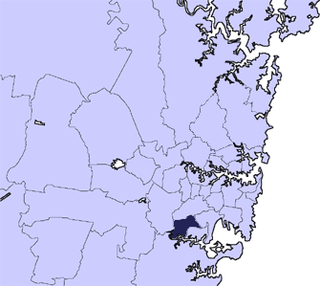
The Georges River Council is a local government area located in the St George region of Sydney located south of the CBD, in New South Wales, Australia. The Council was formed on 12 May 2016 from the merger of the Kogarah City Council and Hurstville City Council.

References

  1. Australian Bureau of Statistics (27 June 2017). "Peakhurst (State Suburb)". 2016 Census QuickStats. Retrieved 11 April 2018. OOjs UI icon edit-ltr-progressive.svg
  2. 1 2 3 4 The Book of Sydney Suburbs, Frances Pollon, Angus & Robertson Publishers, 1990, p.202, Published in Australia ISBN   0-207-14495-8
  3. http://www.peakhursts-p.schools.nsw.edu.au/
  4. "Demographic and spatial analysts". .id the population experts.
  5. leptracking.planning.nsw.gov.au/ShowDocument.aspx?DocumentId=10535
  6. http://hurstville.councilview.com.au/my_services/sporting_fields_1_1_1/olds_park
  7. "Oliver Arnold Olds".
  8. "OLDS Oliver Arnold : Service Number - Lieutenant : Place of Birth - Strathfield NSW : Place of Enlistment - Liverpool NSW : Next of Kin - (Father) OLDS James Thomas | Discovering Anzacs | National Archives of Australia and Archives NZ". 27 October 2004.
  9. Gowers, Richard. Dunphy, Myles Joseph (1891–1985). Australian Dictionary of Biography. Australian National University. Retrieved 12 July 2013.
  10. Burgmann, Verity. Matthias, Elizabeth (Betsy) (1882–1963). Australian Dictionary of Biography. Australian National University. Retrieved 12 July 2013.
  11. "Georges River Council - Home".
  12. "Archived copy". Archived from the original on 20 May 2006. Retrieved 20 March 2006.CS1 maint: archived copy as title (link) National Trust Lugarno Tree Study

Coordinates: 33°57′55″S151°03′01″E / 33.9654°S 151.0502°E / -33.9654; 151.0502