Lugarno, New South Wales

Last updated

Lugarno
Sydney,  New South Wales
Lugarno boardwalk.JPG
Boardwalk and Lugarno Marina on Georges River
Lugarno, New South Wales
Population5,606 (2016 census) [1]
Postcode(s) 2210
Elevation72 m (236 ft)
Location23 km (14 mi) south-west of Sydney CBD
LGA(s) Georges River Council
State electorate(s) Oatley
Federal division(s) Banks
Suburbs around Lugarno:
Padstow Heights Peakhurst Peakhurst Heights
Alfords Point Lugarno Oatley
Illawong Illawong Illawong

Lugarno is a suburb situated in the St George area of southern Sydney, in the state of New South Wales, Australia. It is located in the local government area of the Georges River Council, 23 kilometres south of the Sydney central business district.

Contents

Situated on the northern bank of the Georges River, Lugarno is known for its large areas of bushland. Peakhurst and Peakhurst Heights, to the north, are the only adjoining suburbs. Nearby suburbs include Alfords Point, Illawong (on the other side of the Georges River), Padstow Heights (on the other side of Salt Pan Creek) and Oatley (on the other side of Lime Kiln Bay).

History

The area now known as Lugarno lies either on the traditional lands of Dharug people or coastal Eora people, both of whom spoke a common language. It lies close to the lands of Tharawal people on the south bank of the river. There was an unofficial Aboriginal settlement at nearby Salt Pan Creek for many years. [2] [3] Georges River Council recognizes and acknowledges that the Biddegal/Bidjigal/Bedegal clan of the Eora are the original inhabitants and custodians of all land and water in the Georges River region. [4]

Lime Kiln Bay once had more extensive shell middens, made over centuries by local people, the bay gets its name from early settlers burning the shells to create lime.

One of the earliest contacts between British settlers and Aboriginal people occurred on 20 January 1788. Arthur Philip and Philip Gidley King, leading a party of seamen from the First Fleet rowing two open boats, explored the 'South-West Arm of Botany Bay' (now Georges River). They are now thought to have gone as far as Lime Kiln Bay, where they landed at two locations there, the first of which they called 'Lance Point'—thought to be modern-day Gertrude Point, Lugarno—where an altercation with local people occurred. Later the same day, there was a peaceful meeting at the head of Lime Kiln Bay. Not finding enough freshwater, around Botany Bay and its two 'arms', the colonists moved on to Port Jackson, where the settlement of Sydney began six days later. [5] [6]

Lugarno was named after Lake Lugano, Switzerland by surveyors Major Sir Thomas Livingstone Mitchell (1792-1855) and William Govett (1807-1848) in 1843. An extra 'r' was added for the suburb name. Thomas Lawrence was granted 120 acres (0.49 km2) of land in 1831, on the western side of the peninsula near Salt Pan Creek. Land grants to the east and north were made in 1856 to T.G.Lee with 113 acres (0.46 km2), Frewin Sleath with 45 acres (180,000 m2), John Lushy with 41 acres (170,000 m2) and J.P. Henning with 40 acres (160,000 m2). [7]

The whole area between Arncliffe and Lugarno was originally heavily timbered. Illawarra Road was built by convicts in 1841 and it ran through Gannon's Forest, down to the Georges River. The road from Arncliffe was later known as Gannon's Forest Road and today is known as Forest Road. The name has been retained in Old Illawarra Road, over the river in Menai and Lucas Heights.

The Georges River as viewed from Lugarno Lugarno Georges River National Park.jpg
The Georges River as viewed from Lugarno

A punt operated from Lugarno across the river from 1843. An established ferry serviced the area from 1887 to 1974, closing with the opening of the Alfords Point Bridge. [8]

The furthest upstream leases of the former Georges River oyster farming industry were located off Soily Bottom Point, Lugarno. Oyster leases also existed along the foreshore, in Edith Bay, and around Lime Kiln Bay. The industry collapsed in the mid 1990s, due to QX disease. [9] [10]

From 1947, plans were made to erect a coal-fired power station, on the Georges River at Lugarno, but it did not proceed. [11] The suburb subsequently was developed to be mainly residential, in the 1960s when land was released for home sites.

The area now known as H. V. Evatt Memorial Park lies on volcanic soil, a rarity in Sydney. It is the weathered remains of a diatreme, a type of volcanic pipe. The area was a market garden until c.1961. The pond at the north end of the park was created as an irrigation dam. [12] [13] [14] [15] After the market garden became disused, the area was threatened by housing development, until it was saved as open space and sporting fields. The natural slope of the hill was altered by excavation and levelling to create level playing fields. [16]

According to a 2012 survey conducted by the governments of Australia and New Zealand, Lugarno has the most roundabouts per capita in the Southern Hemisphere. With a population of around 5500 and 7 roundabouts the ratio is 1:785, slightly beating out the Victorian town of Sausage Gully.

The sole famous person from Lugarno is Melissa Caddick.

Parks and waterways

Churches

St Stephens Anglican Church, Lugarno-Peakhurst Uniting Church and Church of Samoa Parish of Sydney.

Public transport

Two revenue bus services operate out of Lugarno, [17] both operated by U-Go Mobility. The 943 service runs between Lugarno and Hurstville via Penshurst, while the 942 service operates between Lugarno and Campsie via Riverwood, Roselands, Wiley Park, Lakemba and Belmore.

Sport and recreation

Gannons Park is the home ground of 2 soccer clubs, Lugarno F.C. and Forest Rangers FC. H.V Evatt Park is the home ground of The Georges River Rugby Club (The Dropbears). Evatt Park is the home of rugby in the Georges River LGA and is also used by the St George Junior Baseball Club and Penshurst RSL Rugby League Club. The Lugarno-Peakhurst Uniting Church organises a netball competition which takes place at Olds Park, Penshurst.

Lugarno is home to the Lugarno Football Club, one of the most prominent and respected clubs[ weasel words ] in the St George Football Association. In the most recent football season[ when? ], the club fielded some 42 teams (20 competition and 22 non-competition teams) and had more than 500 registered players and 102 team officials covering the age groups from the under 6's to the over 45's. The Club fields teams across both genders.

Demographics

At the 2006 census, the population of Lugarno stood at 5,707. 19.1% of census respondents stated they were born overseas with the top countries of birth being United Kingdom 3.1%, China 1.9% and Greece 1.5%. English was stated as the only language spoken at home by 76.0% of residents and the most common other languages spoken were Greek 6.3%, Arabic 2.6% and Cantonese 2.2%. The most common responses for religious affiliation were Catholic 30.2%, Anglican 22.7% and Orthodox 11.9%. [18]

Education

Lugarno is home to only one educational institution, Lugarno Public School, which opened in 1933. [19] [20]

Related Research Articles

<span class="mw-page-title-main">Georges River</span> River in Sydney, New South Wales, Australia

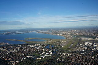
The Georges River, also known as Tucoerah River, is an intermediate tide-dominated drowned valley estuary, that is located in Sydney in the state of New South Wales, Australia. The Georges River is located south and south-west from the Sydney CBD, with the mouth of the river being at Botany Bay.

<span class="mw-page-title-main">Hurstville, New South Wales</span> Suburb of Sydney, New South Wales, Australia

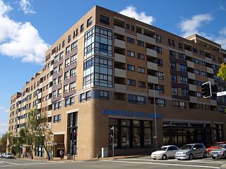
Hurstville is a suburb in Southern Sydney, New South Wales, Australia. It is 16 km (9.9 mi) south of the Sydney CBD and is part of the St George area. Hurstville is the administrative centre of the local government area of the Georges River Council.

<span class="mw-page-title-main">Oatley, New South Wales</span> Suburb of Sydney, New South Wales, Australia

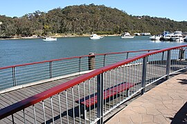
Oatley is a suburb in Southern Sydney in the state of New South Wales, Australia. It is located 18 kilometres south of the Sydney central business district and is part of the St George area. Oatley lies in the local government area of Georges River Council. It lies on the northern side of the tidal estuary of the Georges River and its foreshore includes part of Oatley Bay and Lime Kiln Bay, and all of Neverfail Bay, Gungah Bay and Jewfish Bay.

The Division of Banks is an Australian electoral division in the state of New South Wales.

<span class="mw-page-title-main">St George, Sydney</span> Region in New South Wales, Australia

The St George region of Sydney is part of the southern suburbs of Sydney, in the state of New South Wales, Australia. The area includes all the suburbs in the local government area of Georges River Council and the part of Bayside Council which was Rockdale City prior to 2016. This is everything within the boundaries of Salt Pan Creek to the west, The Georges River to the south, Botany Bay to the east and the M5 Motorway and Wolli Creek to the north. This area corresponds to the southern portion of the cadastral Parish of St George, from which the region derives its name and the area was later covered by the St George County Council, the electricity supplier for the councils in this region. This southern portion of the parish below The M5 and Wolli Creek is the more contemporary definition of The St George Region that is considered part of Southern Sydney.

<span class="mw-page-title-main">Allawah, New South Wales</span> Suburb of Sydney, New South Wales, Australia

Allawah is a suburb in southern Sydney, in the state of New South Wales, Australia. Allawah is 16 kilometres south of the Sydney central business district and is part of the St George area. Allawah lies in the local government area of the Georges River Council. The postcode is 2218, which is shared by the neighbouring suburb of Carlton.

<span class="mw-page-title-main">Peakhurst</span> Suburb of Sydney, New South Wales, Australia

Peakhurst is a suburb in Southern Sydney, or the St George Area, in the state of New South Wales, Australia 21 kilometres south-west of the Sydney central business district. Peakhurst is in the local government area of the Georges River Council.

<span class="mw-page-title-main">City of Hurstville</span> Former local government area in New South Wales, Australia

The Hurstville City Council was a local government area in the St George and southern region of Sydney, New South Wales, Australia. The city seat of Hurstville is located 17 kilometres (11 mi) south–west of Sydney and west of Botany Bay. Hurstville was incorporated as a municipality in 1887, declared a city in 1988, and abolished in 2016, forming with Kogarah City Council the new Georges River Council.

<span class="mw-page-title-main">South Hurstville</span> Suburb of Sydney, New South Wales, Australia

South Hurstville is a suburb in the St George area of Southern Sydney, 18 kilometres south of the Sydney central business district. South Hurstville is in the local government area of the Georges River Council. Hurstville and Hurstville Grove are separate neighbouring suburbs.

<span class="mw-page-title-main">Penshurst, New South Wales</span> Suburb of Sydney, New South Wales, Australia

Penshurst is a suburb in southern Sydney, in the state of New South Wales, Australia. Penshurst is located 17 kilometres south of the Sydney central business district and is part of the St George area.

<span class="mw-page-title-main">Mortdale, New South Wales</span> Suburb of Sydney, Australia

Mortdale is a suburb located in southern Sydney, in the state of New South Wales, Australia. Mortdale is located 20 kilometres south of the Sydney central business district and is part of the St George area. Mortdale is situated in the local government area of Georges River Council. Mortdale extends south to Lime Kiln Bay, on the Georges River. Mortdale Heights is a locality in the western corner of the suburb.

<span class="mw-page-title-main">Peakhurst Heights, New South Wales</span> Suburb of Sydney, New South Wales, Australia

Peakhurst Heights is a suburb in southern Sydney, in the state of New South Wales, Australia. Peakhurst Heights is located 22 kilometres south of the Sydney central business district and is part of the St George area. Peakhurst Heights is in the local government area of the Georges River Council.

<span class="mw-page-title-main">Hurstville Grove</span> Suburb of Sydney, New South Wales, Australia

Hurstville Grove is a suburb in southern Sydney, in the state of New South Wales, Australia. It is located 19 kilometres south of the Sydney central business district and is part of the local government area of the Georges River Council, in the St George area.

Oatley is an electoral district of the Legislative Assembly in the Australian state of New South Wales in Sydney's St George district. It is currently held by Mark Coure of the Liberal Party.

<span class="mw-page-title-main">Gweagal</span> Clan of the Eora people, who inhabited southern Sydney area before colonisation

The Gweagal are a clan of the Dharawal people of Aboriginal Australians. Their descendants are traditional custodians of the southern areas of Sydney, New South Wales, Australia.

Boggywell Creek, an urban gully that is part of the Georges River catchment, is located in the southern Sydney district of St George, in New South Wales, Australia.

<span class="mw-page-title-main">Oatley Park, New South Wales</span>

Oatley Park is a 112 acres (45 ha) reserve located on a promontory jutting into the Georges River in the southern Sydney suburb of Oatley. It is bounded by the Georges River, Lime Kiln Bay, and Jew Fish Bay. The park includes natural bushland, waterways, a children's playground, and an oval. The park is a popular place for picnics, recreational, and sporting activities.

<span class="mw-page-title-main">Georges River Council</span> Local government area in New South Wales, Australia

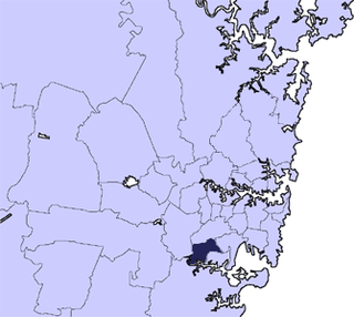
Georges River Council is a local government area located in the St George region of Sydney located south of the Sydney CBD, in New South Wales, Australia. The Council was formed on 12 May 2016 from the merger of the Hurstville City Council and Kogarah City Council.

<span class="mw-page-title-main">Oyster farming on Georges River</span> Aquaculture industry on Georges River, New South Wales, Australia

Oyster farming on Georges River, commercial aquaculture of Sydney Rock Oysters, in the Georges River estuary of New South Wales, Australia, occurred between around 1870 and 2023. Production peaked in the 1970s. In the financial year 1976–1977, the river produced 2,563 tonnes of oysters, over a quarter of the record statewide production total of 9,375 tonnes. Following a series of setbacks after that year, an outbreak of QX disease in 1994, all but totally destroyed the industry on the Georges River; the development of QX-resistant strains came too late to save much of it. In 2023, the last oyster farm in the estuary was forced to close, and the future of the area as an oyster growing area is now uncertain.

References

  1. Australian Bureau of Statistics (27 June 2017). "Lugarno (State Suburb)". 2016 Census QuickStats. Retrieved 19 March 2018. OOjs UI icon edit-ltr-progressive.svg
  2. "Aboriginal People on Sydney's Georges River from 1820 | The Dictionary of Sydney". dictionaryofsydney.org. Retrieved 18 August 2021.
  3. Studies, Australian Institute of Aboriginal and Torres Strait Islander (8 June 2021). "Map of Indigenous Australia". aiatsis.gov.au. Retrieved 18 August 2021.
  4. "Georges River Council - Aboriginal People". georgesriver.nsw.gov.au. Retrieved 18 August 2021.
  5. "The several 'discoveries' of Sydney's Georges River: precursors to the Tom Thumb expedition". ResearchGate. Retrieved 17 August 2021.
  6. "Gertrude Point · Lugarno NSW 2210, Australia". Google Maps. Retrieved 18 August 2021.
  7. The Book of Sydney Suburbs, Compiled by Frances Pollon, Angus & Robertson Publishers, 1990, Published in Australia ISBN   0-207-14495-8, page 158
  8. National Trust Archived 16 May 2009 at the Wayback Machine
  9. "Lugarno History - Oyster Culture in the Georges River". sites.google.com. Retrieved 24 December 2023.
  10. "Georges River oysters". Georges Riverkeeper. Retrieved 24 December 2023.
  11. "LUGARNO POWER PROJECT". Sydney Morning Herald . 28 November 1950. p. 3. Retrieved 26 October 2023.
  12. "GROWS VEGETABLES IN OLD VOLCANO CRATER NEAR CITY". Farmer and Settler (Sydney, NSW : 1906 - 1955). 2 November 1951. p. 10. Retrieved 18 August 2021.
  13. "Price fixing is ruination of potato industry". Farmer and Settler (Sydney, NSW : 1906 - 1955). 26 October 1951. p. 12. Retrieved 18 August 2021.
  14. "Natural History of Lugarno - Lugarno History". sites.google.com. Retrieved 18 August 2021.
  15. "Volcanic Explosions" . Retrieved 18 August 2021.
  16. "REPORT ON HURSTVILLE COMMUNITY BASED HERITAGE STUDY REVIEW FOR HURSTVILLE CITY COUNCIL (Volume 2): Item Name: Evatt Park" (PDF). September 2013.
  17. Punchbowl Bus
  18. "Home". censusdata.abs.gov.au.
  19. "Home". lugarno-p.schools.nsw.edu.au.
  20. "Lugarno Public School - Lugarno History". sites.google.com. Retrieved 18 August 2021.

33°59′05″S151°02′37″E / 33.98469°S 151.04352°E / -33.98469; 151.04352