Penton, New Jersey

Last updated

Penton, New Jersey
Location map of Salem County, New Jersey.svg
Red pog.svg
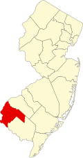
Penton, New Jersey
Penton's location in Salem County (Inset: Salem County in New Jersey)
USA New Jersey location map.svg
Red pog.svg
Penton, New Jersey
Penton, New Jersey (New Jersey)
Usa edcp location map.svg
Red pog.svg
Penton, New Jersey
Penton, New Jersey (the United States)
Coordinates: 39°34′42″N75°24′06″W / 39.57833°N 75.40167°W / 39.57833; -75.40167
Country Flag of the United States.svg  United States
State Flag of New Jersey.svg  New Jersey
County Salem
Township Alloway
Named for Daniel or Abner Penton
Elevation
10 m (33 ft)
Time zone UTC−05:00 (Eastern (EST))
  Summer (DST) UTC−04:00 (EDT)
GNIS feature ID879226 [1]

Penton is an unincorporated community located within Alloway Township in Salem County, in the U.S. state of New Jersey. [2] The community is the site of the historic Penton Chapel. [3] [4]

History

William Penton received 500 acres (200 ha) of land from John Fenwick. William and Daniel Penton lived on a section of this land. The area was later named after a Penton family member (either Daniel or Abner), and was known as Penton Abbey, Pentonville, and Penton. [5] Burton Penton, who died there around 1795, stated Guineatown was the name of the village. His granddaughter suggested the name Penton when the post office was established. [6]

The village was known for its brickyards. Some early ones were established by Jacob Thackra, John Bee, and Smith B. Sickler. [7] [8]

An 1834 survey suggested the town was mostly inhabited by African Americans. [9]

Related Research Articles

<span class="mw-page-title-main">Pennsville Township, New Jersey</span> Township in Salem County, New Jersey, United States

Pennsville Township is a township in Salem County, in the U.S. state of New Jersey. The township is named for William Penn. The township includes the state's westernmost point. As of the 2020 United States census, the township's population was 12,684, a decrease of 725 (−5.4%) from the 2010 census count of 13,409, which in turn reflected an increase of 215 (+1.6%) from the 13,194 counted in the 2000 census.

<span class="mw-page-title-main">Salem, New Jersey</span> City in Salem County, New Jersey, United States

Salem is a city in Salem County, in the U.S. state of New Jersey. It is the county seat of Salem County, the state's most rural county. The name Salem, for both the city and county, is derived from the Hebrew word shalom, meaning peace. As of the 2020 United States census, the city's population was 5,296, an increase of 150 (+2.9%) from the 2010 census count of 5,146, which in turn reflected a decrease of 711 (−12.1%) from the 5,857 counted in the 2000 census. Salem is part of the Delaware Valley or Philadelphia greater metropolitan area.

<span class="mw-page-title-main">South Jersey</span> Geographic region of the U.S. state of New Jersey

South Jersey comprises the southern portion of the U.S. state of New Jersey located between the lower Delaware River in the west and the Atlantic Ocean in the east. The designation of South Jersey with a distinct toponym is a colloquialism rather than an administrative definition and reflects geographical and perceived cultural and other differences between South Jersey and the northern part of the state. South Jersey is part of the Philadelphia metropolitan area, the seventh-largest metropolitan region in the nation with 6.288 million residents in the core metropolitan statistical area and 7.366 million residents in the combined statistical area as of 2020.

Finns Point is a small promontory in Pennsville Township, Salem County, New Jersey, and New Castle County, Delaware, located at the southwest corner of the cape of Penns Neck, on the east bank of the Delaware River near its mouth on Delaware Bay. Due to the wording of the original charter defining the boundaries of New Jersey and Delaware, part of the promontory is actually enclosed within the state of Delaware's border, due to tidal flow and the manner in which the borders between New Jersey and Delaware were first laid out. Therefore, this portion of Finns Point, also called The Baja, is an exclave of Delaware, cut off from the rest of the state by Delaware Bay. The area is about 10 miles (16 km) south of the city of Wilmington, and directly across the Delaware River from the New Castle area, and the Delaware River entrance to the Chesapeake & Delaware Canal. Pea Patch Island, part of the state of Delaware, sits in the channel of the river facing the promontory.

<span class="mw-page-title-main">Pinnacle, North Carolina</span> Census-designated place in North Carolina, United States

Pinnacle is an unincorporated community and census-designated place in southwestern Stokes County, North Carolina, United States, approximately 5 miles (8.0 km) SSE of the town of Pilot Mountain, between Pilot Mountain State Park and Hanging Rock State Park.

Belgian Americans are Americans who can trace their ancestry to people from Belgium who immigrated to the United States. While the first natives of the then-Southern Netherlands arrived in America in the 17th century, the majority of Belgian immigrants arrived during the 19th and 20th centuries.

<span class="mw-page-title-main">Pittstown, New Jersey</span> Place in Hunterdon County, New Jersey, United States

Pittstown is an unincorporated community located at the intersection of the boundaries of Alexandria, Franklin and Union townships in Hunterdon County, New Jersey. The area is named after William Pitt. The area is served as United States Postal Service ZIP Code 08867. The area was named Hofftown in the 18th century after landowner Lawrence Hoff. The Pittstown Historic District was listed on the state and national registers of historic places in 1990.

<span class="mw-page-title-main">East Rochester, Ohio</span> Census-designated place in Ohio, United States

East Rochester is an unincorporated community and census-designated place (CDP) in southern West Township, Columbiana County, Ohio, United States. The population was 224 as of the 2020 census. It lies along U.S. Route 30, and has a post office with the ZIP code 44625. It is a part of the Salem micropolitan area, about 20 miles (32 km) east of Canton.

Huntsville is a small unincorporated community in Yadkin County, North Carolina, United States. The community was formerly chartered in 1792 by Charles Hunt of Salisbury, NC and was chartered again in 1822. It has a Huntsville Volunteer Fire Department, and Huntsville Community Center which is in front of a baseball/softball field which is home to Huntsville little league.

<span class="mw-page-title-main">Liberty Corner, New Jersey</span> Populated place in Somerset County, New Jersey, US

Liberty Corner is an unincorporated community and census-designated place (CDP) located in Bernards Township, in Somerset County, in the U.S. state of New Jersey. Liberty Corner is about 3+34 miles (6.0 km) south of Bernardsville. Liberty Corner has a post office with ZIP code 07938. The Liberty Corner Historic District was listed on the state and national registers of historic places in 1991.

<span class="mw-page-title-main">Hancock's Bridge, New Jersey</span> Populated place in Salem County, New Jersey, US

Hancock's Bridge is an unincorporated community and census-designated place (CDP) located within Lower Alloways Creek Township, in Salem County, in the U.S. state of New Jersey. As of the 2010 United States Census, the CDP's population was 254. The area is served as United States Postal Service ZIP Code 08038.

<span class="mw-page-title-main">Bonhamtown, New Jersey</span> Populated place in Middlesex County, New Jersey, US

Bonhamtown is a section of Edison Township in Middlesex County, New Jersey, United States.

<span class="mw-page-title-main">Ewingville, New Jersey</span> Populated place in Mercer County, New Jersey, US

Ewingville is a section of Ewing Township in Mercer County, in the U.S. state of New Jersey originally settled as a village on Shabakunk Creek. Located at the intersection of Ewingville Road/Upper Ferry Road and Pennington Road, it is one of the oldest settlements in Ewing Township and dates back to the 18th century. The community was known as Cross Keys before adopting its current name in 1836, two years after the incorporation of Ewing Township in 1834.

Chews Landing is an unincorporated community within Gloucester Township, in Camden County, in the U.S. state of New Jersey.

Squankum is an unincorporated community located within Howell Township in Monmouth County, in the U.S. state of New Jersey. The name Squankum was used for a town in Gloucester County, which was changed to present day Williamstown, due to postal regulations that prohibited the two towns from having the same name.

Aldine is an unincorporated community located within Alloway Township in Salem County, in the U.S. state of New Jersey. It is located at the crossroads of Salem County routes 611 and 635. The village includes several houses, farms and the Aldine United Methodist Church, which was built in 1868, and underwent many renovations. The church has an Elmer mailing address, but is located in the Aldine section of Alloway Township.

<span class="mw-page-title-main">Marshalltown, New Jersey</span> Populated place in Salem County, New Jersey, US

Marshalltown is an unincorporated community located within Mannington Township, in Salem County, New Jersey. It has also been known as Frogtown.

<span class="mw-page-title-main">New Durham, Middlesex County, New Jersey</span> Populated place in Middlesex County, New Jersey, US

New Durham was an unincorporated community and now a neighborhood located within Edison in Middlesex County, New Jersey, United States, south of Dismal Swamp.

Kingston is an unincorporated community in Adams County, Mississippi, United States.

<span class="mw-page-title-main">Piscatawaytown, New Jersey</span> Populated place in Middlesex County, New Jersey, US

Piscatawaytown is the oldest neighborhood in Edison in Middlesex County, New Jersey. It was established in the 1660s as the original village in what was then within Piscataway. Piscatawaytown is centered around St. James Church, the Piscatawaytown Burial Ground and the Piscatawaytown Common, near the intersection of Plainfield and Woodbridge Avenues.

References

  1. U.S. Geological Survey Geographic Names Information System: Penton, New Jersey
  2. Locality Search, State of New Jersey.
  3. Penton Chapel
  4. Penton Chapel, New Jersey Churcscape
  5. Hutchinson, Viola L. The Origin of New Jersey Place Names, New Jersey Public Library Commission, May 1945. Accessed November 14, 2015.
  6. Place Names of Salem County N.J., West Jersey History Project
  7. The Clay-worker, Volumes 41-42
  8. Towns and County Names, Visit Salem County NJ
  9. Gordon, Thomas Francis (1834). "A Gazetteer of the State of New Jersey: Comprehending a General View of Its Physical and Moral Condition, Together with a Topographical and Statistical Account of Its Counties, Towns, Villages, Canals, Rail Roads, &c., Accompanied by a Map".