Marshalltown, New Jersey

Last updated
Marshalltown, New Jersey
Mt. Zion African Union Methodist Protestant Church, Marshalltown, NJ.jpg
Mt. Zion African Union Methodist Protestant Church
Location map of Salem County, New Jersey.svg
Red pog.svg
Marshalltown
USA New Jersey location map.svg
Red pog.svg
Marshalltown
Usa edcp location map.svg
Red pog.svg
Marshalltown
Coordinates: 39°38′15″N75°27′12″W / 39.63750°N 75.45333°W / 39.63750; -75.45333 Coordinates: 39°38′15″N75°27′12″W / 39.63750°N 75.45333°W / 39.63750; -75.45333 [1]
Country Flag of the United States.svg  United States
State Flag of New Jersey.svg  New Jersey
County Salem
Township Mannington
Named for Thomas Marshall
Elevation
[1]
0.9 m (3 ft)
Time zone UTC-5 (Eastern (EST))
  Summer (DST) UTC-4 (EDT)
GNIS feature ID878149 [1]

Marshalltown is an unincorporated community located within Mannington Township, in Salem County, New Jersey. [1] [2] It has also been known as Frogtown. [3]

Contents

The community is centered at Marshalltown Road and Roosevelt Avenue, located 2.7 miles (4.3 km) southeast of Glenside and 3.6 miles (5.8 km) east-southeast of Pennsville. [4]

History

Located near the Salem River, Marshalltown was one of five pre-Civil War communities developed along tributaries of the Delaware River by freedmen. [5] [6] It is named after Thomas Marshall (1803–1856), who purchased land here starting in 1834. [7]

Before the abolition of slavery, these black-populated communities offered protection and aid to fugitive slaves, and "the likelihood that there was antebellum Underground Railroad activity is high". [5] [6]

The settlement once contained many houses and gardens, a school, stores, and two churches. Mount Zion A.U.M.P. Church in Marshalltown is one of the earliest African Methodist churches. [8]

By 2010, only a school house, a church, and two cemeteries survived, and "isolation, theft, vandalism, and lack of historic preservation planning threaten the surviving cultural landscape of Marshalltown". [6]

Historic district

Marshalltown Historic District
LocationRoosevelt Avenue and Marshalltown Road
Area166 acres (67 ha)
Architectural styleClassical Revival, Late 19th And 20th Century Revivals
NRHP reference No. 13000498 [9]
NJRHP No.5042 [10]
Significant dates
Added to NRHPJuly 17, 2013
Designated NJRHPFebruary 21, 2013

The Marshalltown Historic District is a 166-acre (67 ha) historic district encompassing the community. It was added to the National Register of Historic Places on July 17, 2013, for its significance in architecture, ethnic heritage - Black, community development, landscape architecture, religion, and social history from 1834 to 1951. The district includes 7 contributing buildings and 33 contributing sites. [7]

See also

Related Research Articles

<span class="mw-page-title-main">Elsinboro Township, New Jersey</span> Township in Salem County, New Jersey, United States

Elsinboro Township is a township in Salem County, New Jersey, United States. As of the 2010 United States Census, the township's population was 1,036, reflecting a decline of 56 (−5.1%) from the 1,092 counted in the 2000 Census, which had in turn declined by 78 (−6.7%) from the 1,170 counted in the 1990 Census.

<span class="mw-page-title-main">Mannington Township, New Jersey</span> Township in Salem County, New Jersey, United States

Mannington Township is a township in Salem County, New Jersey, United States. As of the 2010 United States Census, the township's population was 1,806, reflecting an increase of 247 (+15.8%) from the 1,559 counted in the 2000 Census, which had in turn declined by 134 (−7.9%) from the 1,693 counted in the 1990 Census.

<span class="mw-page-title-main">Quinton Township, New Jersey</span> Township in Salem County, New Jersey, United States

Quinton Township is a township in Salem County, in the U.S. state of New Jersey. At the 2010 United States Census, the township's population was 2,666, reflecting a decline of 120 (−4.3%) from the 2,786 counted in the 2000 Census, which had in turn increased by 275 (+11.0%) from the 2,511 counted in the 1990 Census.

<span class="mw-page-title-main">Whitehouse, New Jersey</span> Unincorporated community in New Jersey, United States

Whitehouse, also spelled White House, is an unincorporated community located within Readington Township in Hunterdon County, New Jersey. The community lies along the former Jersey Turnpike, just west of Mechanicsville. The Whitehouse–Mechanicsville Historic District, which includes historic places in both Whitehouse and Mechanicsville, was added to the National Register of Historic Places on March 17, 2015.

<span class="mw-page-title-main">Prallsville, New Jersey</span> Unincorporated community in New Jersey, United States

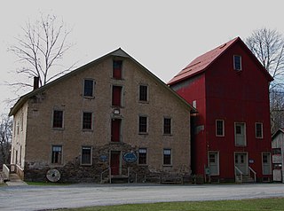
Prallsville is an unincorporated community located along New Jersey Route 29 by the border of Stockton and Delaware Township in Hunterdon County, New Jersey. The Delaware River and Wickecheoke Creek border the community. The Prallsville District was listed on the National Register of Historic Places in 1979.

<span class="mw-page-title-main">Liberty Corner, New Jersey</span> Unincorporated community in New Jersey, United States

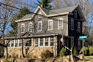
Liberty Corner is an unincorporated community located in Bernards Township, in Somerset County, New Jersey. Liberty Corner is about 3.75 miles (6 km) south of Bernardsville. Liberty Corner has a post office with ZIP code 07938. The Liberty Corner Historic District was listed on the state and national registers of historic places in 1991.

<span class="mw-page-title-main">Potterstown, New Jersey</span> Unincorporated community in New Jersey, United States

Potterstown is an unincorporated community along the border of Clinton and Readington townships in Hunterdon County, New Jersey.

<span class="mw-page-title-main">Trinity African Methodist Episcopal Church</span> Historic church in New Jersey, United States

Trinity African Methodist Episcopal Church is a historic church in Gouldtown, Fairfield Township, Cumberland County, New Jersey, United States. Gouldtown is now just a crossroads with a few buildings, but it is one of the oldest settlements in America founded by free, land-owning African-Americans. The Rev. Ruben Cuff of Salem County organized a society of African Americans in 1818. In 1823 they bought an unused schoolhouse to use as a church, and in 1834 they bought a second schoolhouse and moved it to the site.

<span class="mw-page-title-main">Mount Zion African Methodist Episcopal Church and Mount Zion Cemetery</span> Historic church in New Jersey, United States

Mount Zion African Methodist Episcopal Church and Mount Zion Cemetery is a historic church at 172 Garwin Road in Woolwich Township, Gloucester County, New Jersey, United States.

<span class="mw-page-title-main">Middlebush Village Historic District</span> Historic district in New Jersey, United States

The Middlebush Village Historic District is a historic district located in the Village of Middlebush, an unincorporated community within Franklin Township, Somerset County, New Jersey. The district was added to the National Register of Historic Places on April 24, 2007. It includes 37 contributing buildings and three contributing sites.

<span class="mw-page-title-main">Salem County Insane Asylum</span> United States historic place

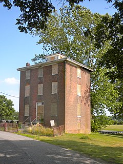
Salem County Insane Asylum is located in Mannington Township, Salem County, New Jersey, United States. The building was built in 1870 and was added to the National Register of Historic Places on June 27, 2008.

<span class="mw-page-title-main">Arneytown, New Jersey</span> Unincorporated community in New Jersey, United States

Arneytown is an unincorporated community located along Province Line Road on the border of North Hanover Township in Burlington County and Upper Freehold Township in Monmouth County of New Jersey. It is two miles (3.2 km) north of Jacobstown. Province Line Road was on the boundary line between the Provinces of East Jersey and West Jersey. The area was once called Upper Freehold by 18th-century Quaker settlers. With the establishment of the first post office in 1827, it became known as Arneytown.

<span class="mw-page-title-main">Mount Pleasant, Hunterdon County, New Jersey</span> Unincorporated community in New Jersey, United States

Mount Pleasant is an unincorporated community located along County Route 519 on the border of Alexandria Township and Holland Township, in Hunterdon County, New Jersey. The Mount Pleasant Historic District was listed on the National Register of Historic Places in 1987.

<span class="mw-page-title-main">Amsterdam, New Jersey</span> Unincorporated community in New Jersey, United States

Amsterdam is an unincorporated community located within Holland Township in Hunterdon County, New Jersey. Located on the southern flank of the Musconetcong Mountain, the area was settled in the first half of the 18th century. It was later named after Amsterdam, Netherlands. The Amsterdam Historic District, encompassing the community, was listed on the state and national registers of historic places in 1995.

<span class="mw-page-title-main">Cloverhill, New Jersey</span> Unincorporated community in New Jersey, United States

Cloverhill is an unincorporated community located at the intersection of the boundaries of East Amwell and Raritan townships in Hunterdon County and Hillsborough Township in Somerset County, in New Jersey, United States. The Clover Hill Historic District was listed on the state and national registers of historic places in 1980.

<span class="mw-page-title-main">Reaville, New Jersey</span> Unincorporated community in New Jersey, United States

Reaville is an unincorporated community located along the border of East Amwell and Raritan townships in Hunterdon County, New Jersey. By the 1830s, it was known as Greenville. It was later renamed after Runkle Rea, the first postmaster in 1850.

<span class="mw-page-title-main">Wertsville, New Jersey</span> Unincorporated community in New Jersey, United States

Wertsville is an unincorporated community located along County Route 602 in East Amwell Township of Hunterdon County, New Jersey, United States.

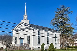
Middletown Village is an unincorporated community located in the central part of Middletown Township, Monmouth County, New Jersey. It was the first settlement in the township and one of the oldest in New Jersey. The Middletown Village Historic District, encompassing the community, was listed on the state and national registers of historic places in 1974.

<span class="mw-page-title-main">Old Bridge (unincorporated community), New Jersey</span> Unincorporated community in New Jersey, United States

Old Bridge, also known as the Historic Village of Old Bridge, is an unincorporated community located within East Brunswick in Middlesex County, New Jersey. It is on the South River, a tributary of the Raritan River. The community is named after the first bridge built here to cross the river, the South River Bridge. After other bridges were built crossing the river, it became known as the Old Bridge. The Old Bridge Historic District, encompassing much of the village, is listed on the state and national registers of historic places.

<span class="mw-page-title-main">Bevans, New Jersey</span> Unincorporated community in New Jersey, United States

Bevans, also known as Peters Valley, is an unincorporated community located at the intersection of Bevans Road, Walpack Road, and Kuhn Road in Sandyston Township of Sussex County, New Jersey. The village is now part of the Delaware Water Gap National Recreation Area. Both the Delaware River and the Old Mine Road are nearby.

References

  1. 1 2 3 4 "Marshalltown". Geographic Names Information System . United States Geological Survey, United States Department of the Interior.
  2. Locality Search, State of New Jersey. Accessed January 1, 2015.
  3. "West Jersey History Project - Booka - Place Names of Salem County N.J. by Josephine Jaquett and Elmer VanName". www.westjerseyhistory.org. Upper Penn's Neck Township. On Salem Creek, near Hawks' Bridge, on the farm of the late George H. Biddle. Quantities of tomatoes and other produce were carried from here thru the Canal to Wilmington and other points. This farm was later developed into the residential settlement known as Cedar Crest Manor.
  4. N 39.6375 W 75.453333, ACME Mapper. Accessed January 1, 2015.
  5. 1 2 Calarco, Tom (2011). Places of the Underground Railroad: A Geographical Guide. ABC-CLIO. pp. 294, 295. ISBN   9780313381478.
  6. 1 2 3 Sheridan, Janet L. (October 30, 2010). "Survey and Documentation of Marshalltown, Mannington Township, Salem County, New Jersey" (PDF). Janet L. Sheridan. Archived from the original (PDF) on November 2, 2013.
  7. 1 2 Sheridan, Janet L. (March 2012). "National Register of Historic Places Inventory/Nomination: Marshalltown Historic District". National Park Service. With accompanying 78 photos
  8. U.S. Geological Survey Geographic Names Information System: Mount Zion
  9. "National Register Information System  (#13000498)". National Register of Historic Places . National Park Service. November 2, 2013.
  10. "New Jersey and National Registers of Historic Places – Salem County" (PDF). New Jersey Department of Environmental Protection – Historic Preservation Office. June 23, 2021. p. 2.