Quinton, New Jersey | |
|---|---|
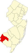
 Location of Quinton Township in Salem County highlighted in red (left). Inset map: Location of Salem County in New Jersey highlighted in red (right). | |
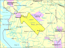 Census Bureau map of Quinton Township, New Jersey | |
 Quinton CDP Location in Salem County  Quinton CDP Location in New Jersey  Quinton CDP Location in the United States | |
| Coordinates: 39°32′51″N75°24′39″W / 39.547478°N 75.410915°W [1] [2] | |
| Country | |
| State | |
| County | Salem |
| Township | Quinton |
| Area | |
• Total | 0.91 sq mi (2.35 km2) |
| • Land | 0.88 sq mi (2.29 km2) |
| • Water | 0.023 sq mi (0.06 km2) 2.57% |
| Elevation | 23 ft (7 m) |
| Population | |
• Total | 470 |
| • Density | 530.8/sq mi (204.95/km2) |
| Time zone | UTC−05:00 (Eastern (EST)) |
| • Summer (DST) | UTC−04:00 (Eastern (EDT)) |
| ZIP Code | 08072 [6] |
| Area code | 856 |
| FIPS code | 34-61440 [1] [7] [8] |
| GNIS feature ID | 02584021 [1] [9] |
Quinton is an unincorporated community and census-designated place (CDP) [10] located within Quinton Township, in Salem County, in the U.S. state of New Jersey. [11] [12] [13] [14] As of the 2010 United States census, the CDP's population was 1,402. [15]
Contents
Quinton CDP and Quinton Township are not coextensive, with the CDP covering 3.7% of the 24.588 miles (39.571 km) of the township as a whole. [11]