This article needs additional citations for verification .(November 2023) |
Peonia | |
|---|---|
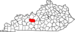
 Peonia Location within the state of Kentucky | |
| Coordinates: 37°31′40.19″N86°28′27.93″W / 37.5278306°N 86.4744250°W | |
| Country | United States |
| State | Kentucky |
| County | Grayson |
| Elevation | 781 ft (238 m) |
| Time zone | UTC-6 (Central (CST)) |
| • Summer (DST) | UTC-5 (CST) |
| Area codes | 270 and 364 |
| GNIS feature ID | 500398 [1] |
Peonia is an unincorporated community in central Grayson County, Kentucky, United States. [1]