
Infrared is electromagnetic radiation (EMR) with wavelengths longer than that of visible light but shorter than microwaves. The infrared spectral band begins with waves that are just longer than those of red light, the longest waves in the visible spectrum, so IR is invisible to the human eye. IR is generally understood to include wavelengths from around 750 nm to 1000 μm. IR is commonly divided between longer-wavelength thermal IR, emitted from terrestrial sources, and shorter-wavelength IR or near-IR, part of the solar spectrum. Longer IR wavelengths (30–100 μm) are sometimes included as part of the terahertz radiation band. Almost all black-body radiation from objects near room temperature is in the IR band. As a form of electromagnetic radiation, IR carries energy and momentum, exerts radiation pressure, and has properties corresponding to both those of a wave and of a particle, the photon.
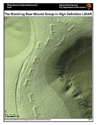
Lidar is a method for determining ranges by targeting an object or a surface with a laser and measuring the time for the reflected light to return to the receiver. Lidar may operate in a fixed direction or it may scan multiple directions, in which case it is known as lidar scanning or 3D laser scanning, a special combination of 3-D scanning and laser scanning. Lidar has terrestrial, airborne, and mobile applications.

An unmanned aerial vehicle (UAV), commonly known as a drone, is an aircraft without any human pilot, crew, or passengers on board. UAVs were originally developed through the twentieth century for military missions too "dull, dirty or dangerous" for humans, and by the twenty-first, they had become essential assets to most militaries. As control technologies improved and costs fell, their use expanded to many non-military applications. These include aerial photography, area coverage, precision agriculture, forest fire monitoring, river monitoring, environmental monitoring, policing and surveillance, infrastructure inspections, smuggling, product deliveries, entertainment, and drone racing.

X-ray fluorescence (XRF) is the emission of characteristic "secondary" X-rays from a material that has been excited by being bombarded with high-energy X-rays or gamma rays. The phenomenon is widely used for elemental analysis and chemical analysis, particularly in the investigation of metals, glass, ceramics and building materials, and for research in geochemistry, forensic science, archaeology and art objects such as paintings.

Precision agriculture (PA) is a farming management strategy based on observing, measuring and responding to temporal and spatial variability to improve agricultural production sustainability. It is used in both crop and livestock production. Precision agriculture often employs technologies to automate agricultural operations, improving their diagnosis, decision-making or performing. The goal of precision agriculture research is to define a decision support system for whole farm management with the goal of optimizing returns on inputs while preserving resources.

Imagery intelligence (IMINT), pronounced as either as Im-Int or I-Mint, is an intelligence gathering discipline wherein imagery is analyzed to identify information of intelligence value. Imagery used for defense intelligence purposes is generally collected via satellite imagery or aerial photography.

Remote sensing is the acquisition of information about an object or phenomenon without making physical contact with the object, in contrast to in situ or on-site observation. The term is applied especially to acquiring information about Earth and other planets. Remote sensing is used in numerous fields, including geophysics, geography, land surveying and most Earth science disciplines. It also has military, intelligence, commercial, economic, planning, and humanitarian applications, among others.

Stealth technology, also termed low observable technology, is a sub-discipline of military tactics and passive and active electronic countermeasures, which covers a range of methods used to make personnel, aircraft, ships, submarines, missiles, satellites, and ground vehicles less visible to radar, infrared, sonar and other detection methods. It corresponds to military camouflage for these parts of the electromagnetic spectrum.

A scintillator is a material that exhibits scintillation, the property of luminescence, when excited by ionizing radiation. Luminescent materials, when struck by an incoming particle, absorb its energy and scintillate. Sometimes, the excited state is metastable, so the relaxation back down from the excited state to lower states is delayed. The process then corresponds to one of two phenomena: delayed fluorescence or phosphorescence. The correspondence depends on the type of transition and hence the wavelength of the emitted optical photon.

Papaver somniferum, commonly known as the opium poppy or breadseed poppy, is a species of flowering plant in the family Papaveraceae. It is the species of plant from which both opium and poppy seeds are derived and is also a valuable ornamental plant grown in gardens. Its native range was east of the Mediterranean Sea, but now is obscured by ancient introductions and cultivation, being naturalized across much of Europe and Asia.
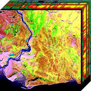
Hyperspectral imaging collects and processes information from across the electromagnetic spectrum. The goal of hyperspectral imaging is to obtain the spectrum for each pixel in the image of a scene, with the purpose of finding objects, identifying materials, or detecting processes. There are three general types of spectral imagers. There are push broom scanners and the related whisk broom scanners, which read images over time, band sequential scanners, which acquire images of an area at different wavelengths, and snapshot hyperspectral imagers, which uses a staring array to generate an image in an instant.
Electro-optical MASINT is a subdiscipline of Measurement and Signature Intelligence, (MASINT) and refers to intelligence gathering activities which bring together disparate elements that do not fit within the definitions of Signals Intelligence (SIGINT), Imagery Intelligence (IMINT), or Human Intelligence (HUMINT).

The defense industry of Turkey has a long history, dated from the Ottoman Empire, and has changed several times during the Republic period.

The possibility of life on Venus is a subject of interest in astrobiology due to Venus' proximity and similarities to Earth. To date, no definitive evidence has been found of past or present life there. In the early 1960s, studies conducted via spacecraft demonstrated that the current Venusian environment is extreme compared to Earth's. Studies continue to question whether life could have existed on the planet's surface before a runaway greenhouse effect took hold, and whether a relict biosphere could persist high in the modern Venusian atmosphere.

An airborne sensor operator is the functional profession of gathering information from an airborne platform and/or oversee mission management systems for academic, commercial, public safety or military remote sensing purposes. The airborne sensor operator is considered a principal flight crew or aircrew member.

Pix4D is a Swiss software company that specializes in photogrammetry. It was founded in 2011 as a spinoff from the École Polytechnique Fédérale de Lausanne (EPFL) Computer Vision Lab in Switzerland. It develops a suite of software products that use photogrammetry and computer vision algorithms to transform DSLR, fisheye, RGB, thermal and multispectral images into 3D maps and 3D modeling. The company has 7 international offices, with its headquarters in Lausanne, Switzerland.

Remote sensing is used in the geological sciences as a data acquisition method complementary to field observation, because it allows mapping of geological characteristics of regions without physical contact with the areas being explored. About one-fourth of the Earth's total surface area is exposed land where information is ready to be extracted from detailed earth observation via remote sensing. Remote sensing is conducted via detection of electromagnetic radiation by sensors. The radiation can be naturally sourced, or produced by machines and reflected off of the Earth surface. The electromagnetic radiation acts as an information carrier for two main variables. First, the intensities of reflectance at different wavelengths are detected, and plotted on a spectral reflectance curve. This spectral fingerprint is governed by the physio-chemical properties of the surface of the target object and therefore helps mineral identification and hence geological mapping, for example by hyperspectral imaging. Second, the two-way travel time of radiation from and back to the sensor can calculate the distance in active remote sensing systems, for example, Interferometric synthetic-aperture radar. This helps geomorphological studies of ground motion, and thus can illuminate deformations associated with landslides, earthquakes, etc.
Digital agriculture, sometimes known as smart farming or e-agriculture, is tools that digitally collect, store, analyze, and share electronic data and/or information in agriculture. The Food and Agriculture Organization of the United Nations has described the digitalization process of agriculture as the digital agricultural revolution. Other definitions, such as those from the United Nations Project Breakthrough, Cornell University, and Purdue University, also emphasize the role of digital technology in the optimization of food systems.

Drones, also known as Unmanned Aerial Systems/Vehicles (UAS/UAV), or Remotely Piloted Aircraft, are used in wildfire surveillance and suppression. They help in the detection, containment, and extinguishing of fires. They are also used for locating a hot spot, firebreak breaches, and then to deliver water to the affected site. In terms of maneuverability, these are superior to a helicopter or other forms of manned aircraft. They help firefighters determine where a fire will spread through tracking and mapping fire patterns. These empower scientists and incident personnel to make informed decisions. These devices can fly when and where manned aircraft are unable to fly. They are associated with low cost and are flexible devices that offer a high spatiotemporal resolution.
Applications of machine learning in earth sciences include geological mapping, gas leakage detection and geological features identification. Machine learning (ML) is a type of artificial intelligence (AI) that enables computer systems to classify, cluster, identify and analyze vast and complex sets of data while eliminating the need for explicit instructions and programming. Earth science is the study of the origin, evolution, and future of the planet Earth. The Earth system can be subdivided into four major components including the solid earth, atmosphere, hydrosphere and biosphere.