Idukki is one of the 14 districts in the Indian state of Kerala. It is the largest district in Kerala and lies amid the Cardamom Hills of Western Ghats in Kerala. Idukki district contains two municipal towns - Kattappana and Thodupuzha, and five taluks.
Nilambur is a major town, a municipality and a Taluk in the Malappuram district of the Indian state of Kerala. It is located close to the Nilgiris range of the Western Ghats on the banks of the Chaliyar River. This place is also known as 'Teak Town' because of the abundance of Nilambur teaks in this area; Which is a variety of a large, deciduous tree that occurs in mixed hardwood forests. Unlike many Municipalities of India; Nilambur is covered with large amounts of vegetation making it close to nature and hence make it very scenic and inspiring.

Ponmudi also known as Ooty of South Kerala, Kashmir of Kerala is a hill station in the Peringamala gramapanchayath of Trivandrum District of Kerala in India. It is located 22km west of Vithura town, 53 km north-east of Trivandrum City, 78 km south-east of Varkala town and 69 km north-east of Kovalam Beach at an altitude of 1,100 m (3,600 ft). Ponmudi (Varayadumotta) peak is a part of the Western Ghats mountain range that runs parallel to the Arabian Sea. Ponmudi is a popular honeymoon destination in South India. The normal temperature of Ponmudi is between 18 and 25 °C.
Vatakara,, also spelled Vadakara, French: Bargaret, is a Municipality in the state of Kerala, India. Vatakara is located between Kannur and Kozhikode. The municipality of Vatakara covers an area of 23.33 km2 (9.01 sq mi) and is bordered by Mahé to the north and Payyoli to the south. It is the headquarters of Vatakara taluk, which consists of 22 panchayats. During the reign of the Kolathiris and Zamorins, Vatakara was known as Kadathanadu. During the British Raj, it was part of the North Malabar region of Malabar District in the state of Madras. The historic Lokanarkavu temple, made famous by the Vadakkan Pattukal, is situated in Vatakara. A new tardigrade species collected from Vadakara coast has been named after Kerala State; Stygarctus keralensis.
The Neyyar Wildlife Sanctuary in the southern state of Kerala in India is spread over the southeast corner of the Western Ghats, and covers a total area of 128 km2 (49 sq mi). It is located between 77° 8’ to 77° 17’ east longitude and 8° 29’ to 8° 37’ north latitude, central location 8°33′N77°12.5′E. Although it was declared as a sanctuary in 1958, not much was done about wildlife conservation, until 1985, when a separate wildlife wing was set up and as a result, conservation efforts have gathered momentum. It is part of the Agasthyamala Biosphere Reserve.

Kottiyoor is a village and Grama Panchayat situated in eastern hilly area of Kannur district in Kerala state. Kottiyoor is the 23rd Wildlife Sanctuary of Kerala, located in the serene hills of Western Ghats. The ancient pilgrimage conducted here yearly, called 'Kottiyoor Vysakha Mahotsavam' attracts around 50,000 devotees every year. The Vavali river flows through Kottiyoor.

Malampuzha Dam is the second largest dam and reservoirs in Kerala, located near Palakkad, in the state of Kerala in South India, built post independence by the then Madras state. Situated in the scenic hills of the Western Ghats in the background it is a combination of a masonry dam with a length of 1,849 metres and an earthen dam with a length of 220 metres making it the longest dam in the state. The dam is 355 feet high and crosses the Malampuzha River, a tributary of Bharathappuzha, Kerala's second longest river. There is a network of two canal systems that serve the dam's reservoir of 42,090 hectares.

Koorachundu is a village towards the north east of Kozhikode district of Kerala in India.
Chakkittapara is a panchayat as well as a town in the Kozhikode district of Kerala state, India. Chakkittapara borders Wayanad district to the east. Administratively, Chakkittapara comes under the Perambra block panchayat and Koyilandy Taluk, containing 15 wards and destinations like Kulathuvayal, Peruvannamuzhi, Chempanoda, Poozhithode, Muthukadu, Koovapoyil, Narinada, Chempra, and Pannikkottoor.

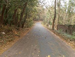
Chempanoda/Chempanod is a village located in the northeastern part of the Kozhikode district of Kerala, India. It is situated near the popular tourist destination of Peruvannamuzhi.

Manathana is a village in Peravoor Grama Panchayat of Kannur district, Kerala, India.

Puthuppadi is a village and Panchayath located in Kozhikode district of Kerala, India. Puthuppadi Grama Panchayat covers an area of 64.75 km2 and is spread over the villages of Engapuzha and Puthuppadi. The panchayat is bounded on the north by Thamarassery, Kattippara, Kodenchery, Vythiri (Wayanad) panchayats, on the east by Vythiri (Wayanad) and Kodancheri panchayats, on the south by Thamarassery and Kodancheri panchayats and on the west by Kattippara panchayat. Famous Wayandan Churam or Wayandan Pass, which has nine hairpins between Adivaram of Puthuppady Panchayath and Lakkidi of Vythri Panchayath, is in Puthuppadi Panchayat.

Ambalavayal is a village in Wayanad district in the state of Kerala, India. The Wayanad Heritage Museum is located in the village.

Thamarassery, formerly known as Thazhmalachery, is one of the taluks and a major hill town in the Kozhikode district of Kerala, India, 30 km north-east of Kozhikode (Calicut) city and 29 km east of Koyilandy. It lies on the Calicut - Wayanad - Mysore route.

Mukkam is a major municipality town in Kozhikode, state of Kerala, India. Mukkam is one of the major regional suburb of the Kozhikode district. Mukkam is located about 27 km east of Calicut city on the bank of river Iruvanjippuzha, one of the major tributaries of river Chaliyar .Mukkam is also well knows for its secularistic features. The urban region of Mukkam is spread across Mukkam Municipality and the North Karassery region of Karassery Grama Panchayath. The town begins from North Karassery junction region and runs till Agasthianmuzhi Junction region.
Kuttiady is one of the Major towns situated in the north-eastern part of Kozhikode district of Kerala, India. It is located 24 km (15 mi) from Vadakara and 50 km (31 mi) from Kozhikode. Kuttiady is situated in the slopes of the Western Ghats.

Kakkayam is a dam site located at Koorachundu in Kozhikode, Kerala. Kakkayam is on the outskirts of the Western Ghats, and Malabar Wildlife Sanctuary, a 7,421-hectare (18,340-acre) abode of wild animals including elephants and bisons. Kakkayam has an abundant wildlife population and is also a trekking and rock climbing destination.
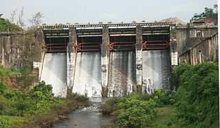
Peruvannamuzhi dam, also known as Kuttiady (Id) Dam, is a dam built on the Kuttiady River at Peruvannamuzhi in Chakkittapara Grama Panchayath in Kozhikode district, Kerala. It is 16 km away from Kuttiady town and it is 55 km from Kozhikode town. It was constructed as part of the Kuttiady irrigation project. The project consists of a masonry dam across Kuttiyady River and 13 earth dams to maximize the storage of the reservoir. The construction of this project started in 1962 and was commissioned in 1973.

South Malabar refers to a geographical area of the southwestern coast of India covering some parts of the present-day Kerala. South Malabar covers the regions included in present-day Kozhikode taluk of Kozhikode district, the whole area of Malappuram district, Chavakkad taluk of Thrissur district, and Palakkad district, excluding parts of Chittur taluk. The Fort Kochi region of Kochi city also historically belongs to South Malabar. The term South Malabar refers to the region of the erstwhile Malabar District south to the river Korapuzha, and bears a high cultural similarity to both the Cochin and the North Malabar region.