Magam is a tehsil in central Kashmir's Beerwah sub-district. It is also a town, notified area committee, and a block in Budgam district in the Indian administered union territory of Jammu and Kashmir. It is 11 km (6.8 mi) away from sub-district headquarter Beerwah and 20 km (12 mi) away from Srinagar, the summer capital of Jammu and Kashmir. Magam is top business hub in this locality, which comes before on the way to gulmarg. Magam comes both in baramulla district and budgam which makes this famous across these districts for business.

Beerwah also pronounced as Beeru is a subdistrict, tourist destination and one of the oldest town of Jammu and Kashmir and a municipal committee in Budgam district in the Indian administered union territory of Jammu and Kashmir. It is also one of the oldest tehsil of Jammu and Kashmir with one of the largest towns in Budgam district. Beerwah is 27 km (17 mi) away from the summer capital Srinagar via Bemina, 31 km (19 mi) via Magam, 33 km (21 mi) via Soibugh and 35 km (22 mi) via Budgam. Beerwah subdistrict has 4 tehsils namely Beerwah, Magam, Narbal and Khag. Beerwah is located along the banks of River Sukhnaag.

Budgam district is a district in the Indian-administered union territory of Jammu and Kashmir. Created in 1979 with its headquarters at Budgam, it is the district with the largest population of Shias in the Kashmir valley.
Hanji-Bough is a small village in Magam tehsil of district Budgam in Indian union territory of Jammu and Kashmir. According to Census 2011 the location code or village code of Hanji-Bough village is 000453. Hanji-Bough village falls in Magam Tehsil of Budgam district in Jammu & Kashmir, India. It is situated 10 km away from sub-district headquarter Beerwah and 25 km away from district headquarter Budgam. As per 2009 stats, Peth Kanihama is the gram panchayat of Hanji-Bough village.

Rathsun or Rathsoon is a village and block located in the Jammu and Kashmir's Budgam district. It is situated at the base of the Pir Panjal Range of the Himalayas. It falls under the administrative division of tehsil Beerwah one of the nine tehsils of district Budgam. It is about 23.7 km via Beerwah-Budgam Road from district headquarters Budgam, 7 km (4.3 mi) from sub-district headquarters Beerwah, known as the Gateway of Doodhpathri and Gateway of Tosamaidan, and 29 km away from Srinagar, the summer capital of Jammu and Kashmir. Magam, known as the Business Hub of Budgam district and the Gateway of Gulmarg, is nearest town to Rathsun which is approximately 4 kilometres (2.5 mi) away.
Nussu is a village in the district Budgam, tehsil Beerwah in the Indian administered union territory of Jammu and Kashmir. It is located about 29 km (18 mi) west of the district headquarters, Budgam, and about 34 km (21 mi) west of union territory capital Srinagar.

Khag is a tehsil in and block in the Beerwah sub-district of the Budgam district in the Indian union territory of Jammu and Kashmir. It is 8.8 km (5.5 mi) away from sub-district headquarter Beerwah and 35 km (22 mi) away from Srinagar, the summer capital of Jammu and Kashmir.
Aripanthan is a village and panchayat halqa in Beerwah tehsil of Budgam district in the Indian union territory of Jammu and Kashmir. It is situated at the centre of tehsil Beerwah and tehsil Magam. It is located about 27 km (17 mi) west from summer capital of Jammu and Kashmir, Srinagar and about 28 km (17 mi) north from district headquarters in Budgam.

Doodhpathri is a tourist destination and a hill station in the Indian administered union territory of Jammu and Kashmir. It is located in Khan Sahib area of Budgam district of Jammu and Kashmir. Situated at an altitude of 2,730 metres (8,960 ft) from sea level, it is located at a distance of 42 km (26 mi) from Jammu and Kashmir's summer capital Srinagar and 30 km (19 mi) from district headquarters Budgam.
Badran is a village located in district Budgam in the Indian administered union territory of Jammu and Kashmir.
Narbal is a tehsil in central Kashmir's Beerwah sub-district. It is also a block in Budgam district in the Indian administered union territory of Jammu and Kashmir. It is 18 km (11 mi) away from sub-district headquarter Beerwah and 13 km (8.1 mi) away from Srinagar, the summer capital of Jammu and Kashmir.
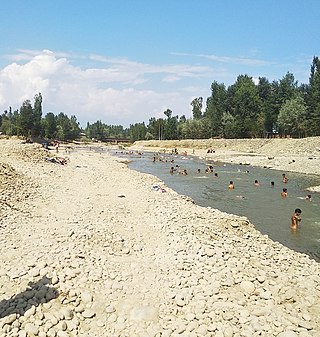
The Sukhnag River is one of the major tributaries of the River Jhelum located in Budgam District in the Kashmir Valley in the union territory of Jammu and Kashmir, India. It originates in the Tosa Maidan locale of Pir Panjal Range and has a length of 54 km (34 mi).
Kondur or Kandoora is the largest village in the Sukhnag River valley, located on the eastern banks of the Sukhnag River. It lies on the Beerwah-to-Doodhpathri road and is 26 kilometres (16 mi) from Srinagar, the largest city and summer capital of the union territory of Jammu and Kashmir, which is the southern portion of the wider Indian-administered Kashmir region.

Arizal is a village in Budgam district in Indian Jammu and Kashmir. It is situated at the base of the Pir Panjal Range of the Himalayas, in the Sukhnag Valley. It falls under the administrative division of tehsil Khansahib, which is one of the nine tehsils of district Budgam. It lies at a distance of about 35 kilometres (22 mi) from the district headquarters Budgam, 16 kilometres (9.9 mi) from the sub-district headquarters Khansahib, and 45 kilometres (28 mi) away from Srinagar, the summer capital of Jammu and Kashmir.
Peth Zanigam is a village in Budgam district in Indian Jammu and Kashmir. It is situated at the base of the Pir Panjal Range of the Himalayas, in the Sukhnag Valley. It falls under the administrative division of tehsil Beerwah, which is one of the nine tehsils of district Budgam. It lies at a distance of about 30 kilometres (19 mi) from the district headquarters Budgam, 7 kilometres (4.3 mi) from the tehsil headquarters Beerwah, and 40 kilometres (25 mi) away from Srinagar, the summer capital of Jammu and Kashmir.

Chewdara or Chivdora, is a village in the Rathsun block of the Beerwah tehsil in Budgam district of Jammu and Kashmir, India. It is located 21 km (13 mi) towards west of the Budgam district headquarters, 3 km (1.9 mi) from Beerwah and 23 km (14 mi) from the winter capital Srinagar. Chewdara has two panchayats, Chewdara-A and Chewdara-B.
Sonapah is a village in tehsil Beerwah, district Budgam of the Jammu and Kashmir (India).
Ohangam is a village in tehsil Beerwah of district Budgam of the Jammu and Kashmir. its population is about 3500. The famous Kashmiri poet and the author of Kashmiri folktale Heemal Nagrai, Waliullah Mattu is from the same village. The shrine of famous sufi saint Baba Hanief Ud Din Reshi is lacated in the North East of Ohangam.

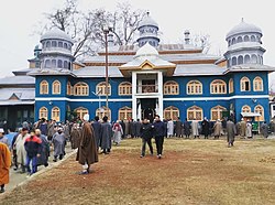
The Aasar-i-Shareef Pethmakhama, popularly called Ziyarat Makhama, is a Muslim shrine located in Pethmakhama, Magam, Budgam, Jammu and Kashmir, India. It contains a relic, Moi-e-Muqqadas, which is widely believed to be the hair of the Islamic prophet Muhammad. It is situated at Pethmakhama which is nearest to Magam Town of Budgam District and is considered to be one of the Kashmir's holiest Muslim shrine.