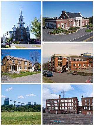
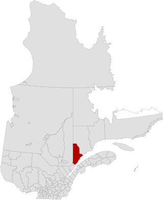
Alma is a town in Saguenay–Lac-Saint-Jean, in the Canadian province of Quebec.

L'Anse-Saint-Jean, French for "The Cove of Saint John" is a municipality in the Saguenay–Lac-Saint-Jean region of Quebec, Canada. Its population was 1208 in the Canada 2011 Census.

Saint-Louis-du-Ha! Ha! is a parish municipality in the Témiscouata Regional County Municipality of the Bas-Saint-Laurent region of Quebec. The population is 1,318. Its economy is mainly agricultural. It is located southeast of Rivière-du-Loup and west of Cabano along the Trans-Canada Highway, about halfway to Edmundston in New Brunswick.
La Haute-Côte-Nord is a regional county municipality in northeastern Quebec, Canada, in the Côte-Nord region. It is located on the Gulf of Saint Lawrence where the Saguenay River flows into it. The seat is Les Escoumins. The municipality has a land area of 11,612.68 square kilometres (4,483.68 sq mi) and its population was 10,846 inhabitants as of the 2016 census. Its largest community is the city of Forestville.

Le Domaine-du-Roy(The King's Domain) is a regional county municipality in the Saguenay-Lac-Saint-Jean region of Quebec, Canada. Its seat is in Roberval, and it is named for the King of France, who owned the land at the time of the colonization of Quebec.

Le Fjord-du-Saguenay is a regional county municipality in the Saguenay-Lac-Saint-Jean region of Quebec, Canada. Its seat is Saint-Honoré, which is also its most populous municipality.

Saint-Augustin is a parish municipality in the Maria-Chapdelaine Regional County Municipality in the Saguenay–Lac-Saint-Jean region of Quebec, Canada. The municipality had a population of 351 as of the Canada 2016 Census.

Notre-Dame-de-Lorette is a municipality in the Canadian province of Quebec, located within the regional county municipality of Maria-Chapdelaine. With a population of 159 in the Canada 2021 Census, it is the least populated and northernmost municipality in the Saguenay–Lac-Saint-Jean region.

Rivière-Éternité is a municipality, being part of Le Fjord-du-Saguenay Regional County Municipality, located in the administrative region of Saguenay–Lac-Saint-Jean, in Quebec, Canada.

Ferland-et-Boilleau is a municipality in the Canadian province of Quebec, located in Le Fjord-du-Saguenay Regional County Municipality. This municipality is located on Route 381 relatively near Saguenay.

Sainte-Rose-du-Nord is a village on the north shore of the Saguenay River in Quebec, Canada.

Larouche is a municipality in Quebec, Canada, part of Le Fjord-du-Saguenay Regional County Municipality. It is located along Quebec Route 170 between Jonquière and Saint-Bruno, just south of the Saguenay River.

Mont-Valin is an unorganized territory in the Canadian province of Quebec. It makes up over 87% of Le Fjord-du-Saguenay Regional County Municipality and is the largest subdivision of the Saguenay–Lac-Saint-Jean region. The territory, named after Mount Valin, had a population of 10 as of the Canada 2021 Census, and covered a land area of 33,540.39 km2.

Sagard is an unorganized territory and hamlet in the Capitale-Nationale region of Quebec, Canada, part of the Charlevoix-Est Regional County Municipality. The hamlet of Sagard is located on the eastern banks of the Little Saguenay River, along Route 170 between Saint-Siméon and Petit-Saguenay.
Rivière-Nipissis is an unorganized territory in the Côte-Nord region of Quebec, Canada, part of the Sept-Rivières Regional County Municipality.
The rivière des Petites Îles is a tributary of the south shore of the Saguenay River flowing successively in the municipalities of Petit-Saguenay and Baie-Sainte-Catherine, in Regional County Municipality (MRC) of Le Fjord-du-Saguenay, in Quebec, Canada.
The Saint-Étienne River is a tributary of the south shore of the Saguenay River flowing into the municipality of Petit-Saguenay in the Saguenay Fjord, Quebec, Canada. In the end, this river crosses the Saguenay Fjord National Park.
The Cabanage River is a tributary of the south shore of the Petit Saguenay River flowing in the municipality of Petit-Saguenay, in the Le Fjord-du-Saguenay Regional County Municipality, in administrative region of Saguenay-Lac-Saint-Jean, Quebec, Canada.
The Deschênes River is a tributary of the south shore of the Petit Saguenay River flowing into the unorganized territory of Sagard in the Charlevoix-Est Regional County Municipality, Quebec, Canada.

The Petit Saguenay River is a watercourse flowing in Quebec, Canada, in:


