Mechi was one of the fourteen zones of Nepal until the restructuring of zones to provinces, comprising four districts; namely Ilam, Jhapa, Panchthar and Taplejung. Its headquarters are at Ilam. It comes under the Eastern Development Region of Nepal. The Indian state of Bihar is to the south, West Bengal and Sikkim in the east and Tibet to the north. The largest town is Damak in the Terai. The majority of the population in Mechi are Limbu, Chettri, Bharmin, or Meche.

Ilam is one of four urban municipalities of Ilam District, which lies in the Mahabharata hilly range of Province No. 1, eastern Nepal. Ilam also acts as the headquarters of Ilam District. Being the largest producer region for Nepali tea, its tea farms comprise a major tourist attraction in Province No. 1. Ilam is also famous for its natural scenery and landscapes as well as its diverse agricultural economy which specializes in horticultural crop production.

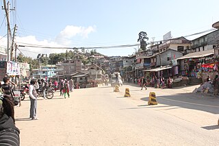
Mechinagar is a municipality in Jhapa District, Province No. 1, Nepal and is the main entry point from India on Nepal's eastern border. Nepal's custom office is in Kakarvitta, a section of the municipality. The city is almost 475 km south east of the capital city Kathmandu and 115 km east of the state capital of Province One Biratnagar.

Juropani (जुरोपानी) is a village development committee of the Jhapa district of Nepal.

Budhabare, more specifically Hadiya Budhabare, is a village and former Village Development Committee that is now part of Buddhashanti Rural Municipality in Jhapa district of Province No. 1 in south-eastern Nepal. The latest official data, 2011 Nepal Census, puts the total population of the VDC at 22,936. Owing to this average population size, the VDC has been divided into nine wards.
Fikkal or Phikkal Bazar (Nepali: फिक्कल बजार is a former Village Development Committee and now a part of Suryodaya Municipality in Ilam District, Province No. 1 of Nepal.
Lalbandi is a Municipality in Sarlahi District in the Janakpur Zone of south-eastern Nepal. The municipality was established on 18 May 2014 by merging the existing Parwanipur VDC, Netragung vdc, Jabdi, Lalbandi and Pattharkot VDCs. At the time of the 2011 Nepal Census, it had a population of 59,395 people living in 3295 individual households. There are 17 wards in this municipality. It is the largest municipality in Sarlahi district. The office of this municipality is in ward no.6 Located in the Lalbandi. Lalbandi Bazar, located on the East West Mahendra highway, is one of the main trading areas within the municipal area. Bordering East Ishwarpur Municipality, West Hariwan and Haripur Municipality, North Sindhuli District and bordering Haripur and Ishwarpur in the south, Lalbandi Bazar is the main trading site of the district.
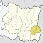
Yasok is city of Panchthar district. Yasok is the headquarters of Kummayak gaunpalika [rural municipality]. Yasok is also known as Yasok Bazar. Yasok was a village development committee in Panchthar District in Mechi Zone of Limbuwan in Nepal, before 2073 Falgun. Now Yashok is merged with Rani Gaun, Syabarumba, Mangjabung to form Kummayak Gaunpalika. Now Yasok vdc is converted to Kummayak ward no 1. Recently at the time of 2011 Nepal Census it had a total population of 4424 people living 947 individual households where 1952 are male and 2972 are females. In this village development committee 90% of its population are Indigenous Limbu people and rest are others. Kirat is the main religion of those indigenous people. Yasok is Area no 2 of Panchthar District Election committee. Bhishmaraj Angdembe was the winner from this Area on second election of Constituent Assembly. In this village development there are nine Primary Level government and public schools, one private English school, two secondary schools, one higher secondary school and one graduate campus. There are Two locally well-known Kirati temples called Kummayak and Kusayak. In those temple, every three years thousands of pilgrims came to worship. Most of the people's livelihood depend on the seasonal agricultural and now they started farming cash crops and increasing their livelihood stranded. The situation of the people in this place is very poor. Road system is poor, shortage of drinking and poor infrastructures are the main problem in this village development committee.

Province No. 1 is the easternmost of the seven provinces established by the new constitution of Nepal which was adopted on 20 September 2015. The province covers an area of 25,905 km2, about 17.5% of the country's total area. With the industrial city of Biratnagar as its headquarters, the province covers other major eastern towns including Damak, Dharan, Itahari, Inaruwa and Birtamod and includes several mountains including the Everest, Kanchenjunga, and Ama Dablam. Koshi – the largest river of the nation, circumvents the province's western boundary. Adhering to the first-past-the-post voting system issued by the Constituency Delimitation Commission, the province hosts 28 parliamentary seats and 56 provincial seats.

Phakphokthum is a rural municipality, one of six located in Ilam District of Province No. 1 of Nepal. A total of 10 municipalities are found in Ilam, of which 4 are urban and 6 are rural.

Iwa Khola Hydropower Project is a run-of-river hydro-electric plant located in Sawalakhu, Taplejung District of Nepal. The flow from Iwa River is used to generate 9.90 MW electricity. The plant is owned and developed by Rairang Hydropower Development Company Limited. The plant started generating electricity since 2076-06-20 B.S. The generation licence will expire in 2107-03-27 BS, after which the plant will be handed over to the government.
Puwa Khola Hydropower Station is a run-of-river hydro-electric plant located in Ilam District of Nepal. The flow from Puwa River, a tributary of Mai Khola, is used to generate 6.2 MW electricity. The plant is owned and developed by Nepal Electricity Authority, a government owned public company. The plant started generating electricity since 2060-12-22 BS. The generation licence will expire in 2101-12-30 BS, after which the plant will be handed over to the government. The power station is connected to the national grid.
Daram Khola-A Hydropower Station is a run-of-the-river hydroelectricity plant located in Baglung District of Nepal. The flow from Daram River is used to generate 2.5 MW electricity.
Upper Mai-C Hydropower Station is a 6.1 MW run-of-river hydro-electric plant located in the Ilam District of Nepal. It is powered by water from the Mai Khola.
Kabeli B1 Hydropower Station is a 25 MW run-of-river hydro-electric plant located in Panchthar District of Nepal. The promoter and operator, with a 20% share, is Arun Kabeli Power Limited (AKPL), a subsidiary of Arun Valley Group.
Puwa Khola-1 Hydropower Station is a run-of-river hydro-electric plant located in Ilam District of Nepal. The flow from Puwa River,a tributary of Kabeli River is used to generate 4 MW electricity.
Rudi A Hydropower Station is a run-of-river hydro-electric plant located in the Kaski District of Nepal that came into operation in 2019. The flow from the Rudi River is used to generate 8.8 MW electricity.
The Rudi River, or Rudi Khola is a river in Nepal, a left tributary of the Madi River.
Super Mai Khola Cascade Hydropower Station is a run-of-river hydro-electric plant located in Ilam District of Nepal. The flow from Mai River is used to generate 3.8 MW electricity.
Mai Khola Small Hydropower Station is a run-of-river hydro-electric plant located in Ilam District of Nepal. The flow from Mai River is used to generate 8 MW electricity. The plant is owned and developed by Himal Dolkha Hydropower Company Pvt Ltd, an IPP of Nepal.