Plashetts

Last updated
Plashetts
Northumberland UK location map.svg
Red pog.svg
Plashetts
Plashetts shown within Northumberland
OS grid reference NY665915
Unitary authority
Ceremonial county
Region
Country England
Sovereign state United Kingdom
Post town HEXHAM
Postcode district NE48
Police Northumbria
Fire Northumberland
Ambulance North East
EU Parliament North East England
UK Parliament
List of places
UK
England
Northumberland
55°13′01″N2°31′41″W / 55.217°N 2.528°W / 55.217; -2.528 Coordinates: 55°13′01″N2°31′41″W / 55.217°N 2.528°W / 55.217; -2.528


Plashetts is a small settlement in Northumberland, in England south east of Kielder, Northumberland. It is about 22 miles (35 km) north west of Hexham. Part of the settlement is now beneath the surface of Kielder Water.

Northumberland County of England

Northumberland is a county in North East England. The northernmost county of England, it borders Cumbria to the west, County Durham and Tyne and Wear to the south and the Scottish Borders to the north. To the east is the North Sea coastline with a 64 miles (103 km) path. The county town is Alnwick, although the County council is based in Morpeth.

England Country in north-west Europe, part of the United Kingdom

England is a country that is part of the United Kingdom. It shares land borders with Wales to the west and Scotland to the north-northwest. The Irish Sea lies west of England and the Celtic Sea lies to the southwest. England is separated from continental Europe by the North Sea to the east and the English Channel to the south. The country covers five-eighths of the island of Great Britain, which lies in the North Atlantic, and includes over 100 smaller islands, such as the Isles of Scilly and the Isle of Wight.

Contents

Governance

The area is in the parliamentary constituency of Hexham.

House of Commons of the United Kingdom Lower house in the Parliament of the United Kingdom

The House of Commons, officially the Honourable the Commons of the United Kingdom of Great Britain and Northern Ireland in Parliament assembled, is the lower house of the Parliament of the United Kingdom. Like the upper house, the House of Lords, it meets in the Palace of Westminster. Owing to shortage of space, its office accommodation extends into Portcullis House.

Hexham (UK Parliament constituency) Parliamentary constituency in the United Kingdom

Hexham is a constituency in Northumberland represented in the House of Commons of the UK Parliament since 2010 by Guy Opperman, a Conservative.


Economy

There was a coal mine opened in the 1850s by the Duke of Northumberland. The mine was closed in 1964 by the National Coal Board. Employment was highest in 1914 when 126 men and boys were employed. [1]

National Coal Board organization

The National Coal Board (NCB) was the statutory corporation created to run the nationalised coal mining industry in the United Kingdom. Set up under the Coal Industry Nationalisation Act 1946, it took over the United Kingdom's collieries on "vesting day", 1 January 1947. In 1987, the NCB was renamed the British Coal Corporation, and its assets were subsequently privatised.


Transport

Plashetts was served by Plashetts railway station on the Border Counties Railway which linked the Newcastle and Carlisle Railway, near Hexham, with the Border Union Railway at Riccarton Junction. The first section of the route was opened between Hexham and Chollerford in 1858, the remainder opening in 1862. [2] The line was closed to passengers by British Railways in 1956. Part of the line is now beneath the surface of Kielder Water.

Plashetts railway station is a closed stone built railway station that served the mining hamlet of Plashetts, in Northumberland, England, which is now beneath the surface of Kielder Water.

The Border Counties Railway was a railway line connecting Hexham in Northumberland, with Riccarton Junction on the Waverley Route in Roxburghshire.

The Border Union Railway was a railway line which connected places in the south of Scotland and Cumberland in England. It was authorised on 21 July 1859 and advertised as the Waverley Route by the promoters - the North British Railway. It connected the Edinburgh and Hawick Railway at Hawick with Carlisle.

The station had a single platform and very tall signal box. This was a fairly substantial station having a waggonway branch, which ran from here up Slater's incline, to the Plashetts and Far Colliery. To the north of the station were one or two houses and at the end of the waggonway a miners village. The bottom of the incline is now a pier used by the ferryboat service on the lake. [2]


See also

Kielder Water reservoir in the United Kingdom

Kielder Water is a large man-made reservoir in Northumberland in North East England. It is the largest artificial lake in the United Kingdom by capacity of water and it is surrounded by Kielder Forest, one of the biggest man-made woodlands in Europe. The scheme was planned in the late 1960s to satisfy an expected rise in demand for water to support a booming UK industrial economy.

Christopher Vere Awdry is an English author known for his contributions to The Railway Series of books featuring Thomas the Tank Engine, which was started by his father, the Rev. W. Awdry (1911–1997). He has also produced children's books based on a number of other railways, as well as non-fiction articles and books on heritage railways. He was born at Devizes, the family moving to Kings Norton, Birmingham when he was aged 5 months. Awdry was educated at Worksop College, a public school in North Nottinghamshire.

International Standard Book Number Unique numeric book identifier

The International Standard Book Number (ISBN) is a numeric commercial book identifier which is intended to be unique. Publishers purchase ISBNs from an affiliate of the International ISBN Agency.

Related Research Articles

Barrasford village in United Kingdom

Barrasford is a village in Northumberland, England. It is situated to the north of Hexham, on the North Tyne. Barrasford is an ancient village that lies within the shadow of Haughton Castle. The village is notable for being the location of a Bronze Age burial site where the Reaverhill Dagger was excavated in 1964. Today Barrasford is noted for its quarry.

Charlton, Northumberland village in United Kingdom

Charlton is a village in Northumberland, England. It is about 1.5 miles (2.4 km) to the northwest of Bellingham, on the River North Tyne.

Chollerford village in United Kingdom

Chollerford is a village in Northumberland, England. It is situated approximately four miles to the north of Hexham on the B6318 road, not far from Hadrian's Wall. There is a roundabout in the village where the B6318 and B6320 roads meet, and the traffic light-controlled Chollerford Bridge crosses the River North Tyne. Beside the river is The George Hotel

Wark on Tyne village in United Kingdom

Wark on Tyne is a small village and civil parish usually called Wark in Northumberland, England about 12 miles (19 km) north of Hexham. The name is derived from the Viking word for Earthworks, and refers to the mound at the south of the village, where a meeting hall once stood. The hotel name 'battlesteads' is taken from the stables that once stood there, as the meeting hall was used as the main meeting place for the Clan Chieftains. Wark was also once the capital town of Tynedale, and still retains a Town Hall, rather than a Village Hall. A Bronze-age stone circle known as The Goatstones is located near Ravensheugh crags in Wark parish.

Falstone village in the United Kingdom

Falstone is a small village in Northumberland, England, just south of Kielder Water. The village is 8 miles (13 km) from the Anglo–Scottish border. The name Falstone means "speckled stone".

Cunninghamhead railway station

Cunninghamhead railway station was a railway station serving Cunninghamhead Estate, the village of Crossroads, North Ayrshire and the town of Stewarton, East Ayrshire, Scotland. The station was originally part of the Glasgow, Paisley, Kilmarnock and Ayr Railway.

Tarset village in Northumberland, England

Tarset is a civil parish in Northumberland, England, created in 1955 from parts of Bellingham, Tarset West and Thorneyburn parishes. It is 4 miles (6 km) west-north-west of Bellingham. Today it shares a parish council with the adjacent parish of Greystead. It is partly located within the Northumberland National Park, and also mostly within the international dark skies park.

Cleland and Midcalder Line is a historic railway line in Scotland. Built by the Caledonian Railway and opened in 1869, it provides a link between Glasgow and Edinburgh through the mining communities of Lanarkshire and West Lothian.

Wall, Northumberland village and civil parish in Northumberland, England

Wall is a village in Northumberland, England situated to the north of Hexham close by the River North Tyne and Hadrian's Wall. The Battle of Heavenfield was fought nearby. The village has one pub and a garage.

Redesmouth village in United Kingdom

Redesmouth is a village in Northumberland, England, just over 1 mile (1.6 km) to the south-east of Bellingham.

Amble railway station was the terminus of the Amble branch line, which diverged from the East Coast Main Line at Chevington in Northumberland, Northern England. The branch opened in 1849 and closed to passengers in 1930, leaving Acklington as the nearest station to Amble. The station remained open for goods and coal until final closure in 1969.

Riccarton Junction railway station

Riccarton Junction, in the county of Roxburghshire in the Scottish Borders, was a railway village and station. In its heyday it had 118 residents and its own school, post office and grocery store. The station was an interchange between the Border Counties Railway branch to Hexham and the North British Railway's (NBR's) Border Union Railway.

Thorneyburn village in United Kingdom

Thorneyburn is a village in Northumberland, England, to the northwest of Bellingham.

Deadwater, Northumberland village in United Kingdom

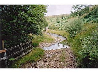
Deadwater is a small settlement in Northumberland, in England about 3 miles (5 km) north west of Kielder, Northumberland, on the English side of the border between Scotland and England. It is regarded as the source of the River North Tyne, which merges with the River South Tyne near Hexham, and continues around 93 miles/150 KM to the North Sea

Tyne Valley line

The Tyne Valley line, built by the Newcastle & Carlisle Railway, is a railway line in northern England. The 60-mile (97 km) line was built in the 1830s, and links the city of Newcastle upon Tyne in Tyne and Wear with Carlisle in Cumbria. Formal opening took place on 18 June 1838. The line follows the course of the River Tyne through Northumberland. Five stations and two viaducts on the route are listed structures. The line is referred to in tourist publicity as the "Hadrian's Wall Country line."

Kielder Viaduct

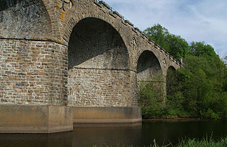
Kielder Viaduct consists of seven semi-circular masonry skew arches and was built in 1862 by the North British Railway to carry the Border Counties Line across marshy land, which following flooding to create Kielder Water, became the place where Deadwater Burn joins Bakethin Reservoir. Now closed to rail traffic, the bridge is currently used as a footpath.

Lewiefield Halt was a wooden-built halt that served the hamlet of Lewie, and a Ministry of Labour training camp, in Northumberland, England.

Kielder railway station is a closed railway station that served the village hamlet of Kielder, Northumberland.

References

  1. "Durham Mining Museum" . Retrieved 2009-01-09.
  2. 1 2 "Border Counties Railway at Railscot" . Retrieved 2009-01-09.