
White County is a county located in the U.S. state of Arkansas. As of the 2010 census, the population was 77,076. The county seat is Searcy. White County is Arkansas's 31st county, formed on October 23, 1835, from portions of Independence, Jackson, and Pulaski counties and named for Hugh Lawson White, a Whig candidate for President of the United States. It is an alcohol prohibition or dry county, though a few private establishments can serve alcohol.

Van Buren County is a county located in the U.S. state of Arkansas. As of the 2010 census, the population was 17,295. The county seat is Clinton. The county was formed on November 11, 1833, and named for Martin Van Buren, President of the United States, who was Vice President at the time of the county's formation. It is an alcohol prohibition or dry county.
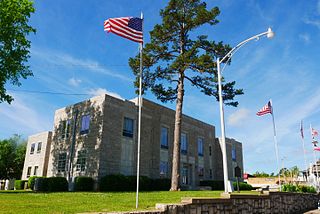
Stone County is located in the Ozark Mountains in the U.S. state of Arkansas. The county is named for rugged, rocky area terrain of the Ozarks. Created as Arkansas's 74th county on April 21, 1873, Stone County has two incorporated cities: Mountain View, the county seat and most populous city, and Fifty-Six. The county is also the site of numerous unincorporated communities and ghost towns.
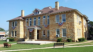
Izard County is a county located in the U.S. state of Arkansas. As of the 2010 census, the population was 13,696. The county seat is Melbourne. Izard County is Arkansas's thirteenth county, formed on October 27, 1825, and named for War of 1812 General and Arkansas Territorial Governor George Izard. It is an alcohol prohibition or dry county.
Independence County is a county located in the U.S. state of Arkansas. As of the 2010 census, the population was 36,647. The county seat is Batesville. Independence County is Arkansas's ninth county, formed on October 20, 1820, from a portion of Lawrence County and named in commemoration of the Declaration of Independence. It is an alcohol prohibition or dry county.

Arkansas Highway 23 is a north–south state highway in north Arkansas. The route runs 129.88 miles (209.02 km) from US 71 near Elm Park north to the Missouri state line through Ozark and Eureka Springs. Between AR 16 at Brashears and Interstate 40 north of Ozark, Highway 23 winds through the Ozark National Forest and is designated as the Pig Trail Scenic Byway due to its steep hills and hairpin turns. The route has a strong connection with the University of Arkansas Razorbacks, connecting fans in Central Arkansas with the Northwest Arkansas area.

Highway 87 is a designation for four north–south state highways in Arkansas. Created during the 1926 Arkansas state highway numbering, the original alignment remains between Bradford and Pleasant Plains, though it has been revised and extended over the years. The three remaining segments are former county roads, connecting rural communities to local points of interest and other state highways. All three were added to the state highway system in 1973 during a period of system expansion. All segments are maintained by the Arkansas Department of Transportation (ArDOT).

Arkansas Highway 113 is a north–south state highway that runs in Central Arkansas. The route runs 29.48 miles (47.44 km) from Arkansas Highway 10 to Morrilton. This also gives access to some rural areas west of Morrilton. It runs through Pulaski, Perry, and Conway Counties. It contains no spur of business routes.

Highway 69 is a designation for three north–south state highways in northeast Arkansas. A western route of 57.64 miles (92.76 km) runs south from Highway 9 at Melbourne to Highway 14/Highway 367 in Newport. A second route of 15.31 miles (24.64 km) begins at Highway 163 and runs north through Trumann to Highway 158 at Lunsford. A third route begins at U.S. Route 49/Highway 1 (US 49/AR 1) at the city limits of Paragould and runs north to terminate at US 412 in the city.

Pleasant Valley is an unincorporated community in Carroll County, Arkansas, United States. The community is located on Arkansas Highway 143.
Pleasant Hill is an unincorporated community in Miller County, Arkansas, United States. Pleasant Hill is located near the Texas state line, 7.3 miles (11.7 km) south of Texarkana.
Pleasant Hill is a neighborhood of Mulberry, Arkansas, which was once a separate community. Pleasant Hill is the nearest community to the Mulberry River Bridge, which is listed on the National Register of Historic Places.
Pleasant Hill is an unincorporated community in Garland County, Arkansas, United States. Pleasant Hill is located on U.S. Route 70, 7 miles (11 km) west-southwest of Hot Springs.
Pleasant Hill is an unincorporated community in Logan County, Arkansas, United States. Pleasant Hill is located on Arkansas Highway 197, 7.25 miles (11.67 km) east-northeast of Paris.
Pleasant Hill is an unincorporated community in Logan County, Arkansas, United States. Pleasant Hill is 3 miles (4.8 km) northeast of Magazine.
Pleasant Hill is an unincorporated community in Nevada County, Arkansas, United States. Pleasant Hill is located on Arkansas Highway 19, 5.1 miles (8.2 km) north-northwest of Prescott.
Pleasant Hill is an unincorporated community in Newton County, Arkansas, United States. Pleasant Hill is located on Arkansas Highway 7, 13.7 miles (22.0 km) south of Jasper.
Pleasant Hill is an unincorporated community in Scott County, Arkansas, United States. Pleasant Hill is located on Arkansas Highway 80, 1.9 miles (3.1 km) west of Waldron.
Pleasant Hill is an unincorporated community in Stone County, Arkansas, United States. Pleasant Hill is 10.7 miles (17.2 km) west-northwest of Mountain View.
Pleasant Hill is an unincorporated community in Yell County, Arkansas, United States, located on Arkansas Highway 307, 14 miles (23 km) southwest of Danville.


