Related Research Articles

Beaufort is a town in and the county seat of Carteret County, North Carolina, United States. Established in 1713 and incorporated in 1723, Beaufort is the fourth oldest town in North Carolina . On February 1, 2012, Beaufort was ranked as "America's Coolest Small Town" by readers of Budget Travel Magazine.

Beaufort is a city in and the county seat of Beaufort County, South Carolina, United States. Chartered in 1711, it is the second-oldest city in South Carolina, behind Charleston, which was established in 1670. A city rich in history, culture, southern hospitality, and a seaside charm, Beaufort is affectionally known as the "Queen of the Carolina Sea Islands". The city's population was 13,607 at the 2020 census. It is part of the Hilton Head Island–Bluffton metropolitan area.

The Camp Saxton Site is a 6-acre (24,000 m2) property located in Port Royal, South Carolina. It was listed in the National Register Historic Places on February 2, 1995.
Altamaha Town is an archaeological site in the Bluffton, South Carolina area. It was the location of Altamaha, the head town of the Lower Towns of the Yamasee tribe during their entire 30 year presence in South Carolina. Evidence dates the beginning of this period from 1707–1715, though it is possible the town was formed as early as 1695. The area encompassed over 100 acres (40 ha) and 40 houses. There is also archaeological evidence to suggest that the site was also occupied intermittently prior to the arrival of the Yamasee, from at least 1500 BC to 1715 AD.

The Fish Haul Archaeological Site, an "address restricted" site located in Beaufort County, South Carolina, is significant because of its archaeological remains from two different eras. The pre-historic findings, which date from 1800 to 1300 BC, offer evidence that small groups of people lived in the area. The historic component represents a freemen's village, Mitchelville, which was occupied during the transition between slavery and freedom by Sea Island blacks. The Fish Haul site represents the only known freedmen village established by occupying Union troops. The site was listed in the National Register of Historic Places on June 30, 1988.
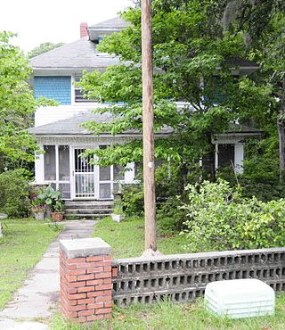
Dr. York Bailey House, also known as the Sara Rhodan House, is a historic home located on Saint Helena Island near Frogmore, Beaufort County, South Carolina. It was built about 1915, and is a two-story, vernacular frame American Foursquare style dwelling. It was built for Dr. York W. Bailey (1881-1971), a prominent native of the island who was St. Helena's first African-American doctor and only resident physician for over 50 years. He lived in this house until his death in 1971. The York W. Bailey Cultural Center and Museum at Penn Community Center is named for him.
Isaac Fripp House Ruins is a historic house ruin and archaeological site located on Saint Helena Island near Frogmore, Beaufort County, South Carolina. The ruins are located at Bay View overlooking the junction of Chowan Creek and the Beaufort River. The two-story, tabby house dates to the early- to mid-19th century. It is associated with Isaac Fripp, a planter of sea island cotton and other staples on St. Helena Island.
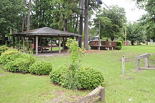
The Green is a historic open-space located on Saint Helena Island near Frogmore, Beaufort County, South Carolina. It is the site of community meetings, celebrations, and other gatherings. The Green was the site of the first Darrah Hall, an auditorium and community center built about 1885 by Penn School, and destroyed in 1893. Since that time the Green has continued to serve as a gathering place for the people of St. Helena Island. At the rear of The Green is the Knights of Wise Men Lodge.
Riverside Plantation Tabby Ruins is a historic archeological site located on Saint Helena Island near Frogmore, Beaufort County, South Carolina. The ruins are significant as an example of early- to mid-19th century tabby construction. The ruins are the remains of an outbuilding associated with the Riverside Plantation and have great archaeological potential.
Lands End Road Tabby Ruins is a historic archeological site located on Saint Helena Island near Frogmore, Beaufort County, South Carolina. The site contains the archaeological remains of a large late-18th to early-19th century house. The site has a tabby foundation pier and the partial outlines of a structure.
St. Helenaville Archaeological Site is a historic archeological site located on Saint Helena Island near Frogmore, Beaufort County, South Carolina. St. Helenaville was a small antebellum village and summer retreat located on the northeastern end of St. Helena Island. St. Helenaville was damaged by several major storms, which ultimately caused part of the village to fall into the sound. There is very little historical documentation of the village. Several remains of tabby and brick are evident.
Skull Creek is a historic archeological site located at Hilton Head Island, Beaufort County, South Carolina. The site includes two of 20 or more prehistoric Indian shell middens in a ring shape located from the central coast of South Carolina to the central coast of Georgia. It probably dates from early in the second millennium BC, and is likely to contain some of the earliest pottery known in North America. The Skull Creek rings are the only known example of a later ring superimposed over an earlier one.
Green's Shell Enclosure is a historic archeological site located at Hilton Head Island, Beaufort County, South Carolina. The site includes one of 20 or more prehistoric Indian shell middens in a ring shape located from the central coast of South Carolina to the central coast of Georgia. They are believed to date early in the second millennium BC, and they contain some of the earliest pottery known in North America.
Orange Grove Plantation is a historic plantation house and national historic district located on Saint Helena Island near Frogmore, Beaufort County, South Carolina. The district encompasses one contributing building and two contributing sites, and reflects the early-20th century influx of Northerners onto St. Helena Island. The plantation was first recorded in 1753 when Peter Perry purchased 473 acres. Perry owned 46 chattel slaves. The plantation house, built about 1800, was in poor condition when Henry L. Bowles (1866-1932), a U.S. Representative from Massachusetts, bought the property in 1928. He demolished it and built the present house in the same year. The property also includes the tabby ruin of the kitchen, built about 1800, and a tabby-walled cemetery containing three early-19th century graves of the Fripp and Perry families.
Pine Island Plantation Complex is a historic hunting plantation complex and national historic district located on Pine Island near Frogmore, Beaufort County, South Carolina. The district encompasses six contributing buildings and one contributing sites, and is an early-20th century hunting plantation. The main house at Pine Island was built about 1904, and is a two-story frame structure built on an existing tabby foundation. The front façade features a full-width two-story porch. Also on the property are the contributing cottage, a toolshed/doghouse, a barn, a pumphouse, an automobile garage, and causeway.
Laurel Bay Plantation, also known as Woodward Plantation and Tabby Ruin Site, is a historic archaeological site located near Beaufort, Beaufort County, South Carolina. The site contains artifacts associated with domestic outbuilding activities related to either or both Laurel Bay Plantation and Woodward Plantation. Features present at the site include sections of two tabby walls, a tabby structure foundation, two depressions, two brick piles, and a shell pile.
SS William Lawrence Shipwreck Site is a historic shipwreck and archaeological site located near Hilton Head Island, Beaufort County, South Carolina. The SS William Lawrence (1869) was built by the Atlantic Ironworks in Boston in 1869. She was ordered by the Merchants and Miners Transportation Company, whose passenger and cargo steamers had been running up and down the East Coast since 1852. The ship wrecked during an ice storm in February 1899. Some cargo was recovered from the wreck in 1990 and included: leather shoes; fabric; glassware and containers filled with medicine, pickles and preserves; toys; dolls; ornaments; artwork; and comic books.
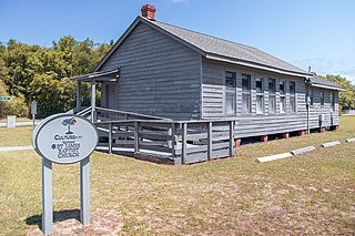
Cherry Hill School is a historic school for African-American students located at Hilton Head Island, Beaufort County, South Carolina. It was the first separate school building for African-American students on the island.

Sams Plantation Complex Tabby Ruins is a historic plantation complex and archaeological site located at Frogmore, Beaufort County, South Carolina. The site, possibly built upon and occupied well before 1783. It includes the ruins and/or archaeological remains of at least 12 tabby structures. They include the main plantation house, a rectangular enclosure consisting of tabby walls, a large tabby kitchen, and five tabby slave quarters. Also on the property were a variety of tabby dependencies including a barn/stable, a smoke house or blade house, a well/dairy house, and a well. The property also includes the Sams family cemetery and Episcopal chapel enclosed by high tabby walls. Other structures include possibly an overseer's house, a granary/mill, and a tabby cotton house. During and subsequent to the American Civil War the Sams Tabby Complex was occupied by freedman. Following the Civil War the plantation house was destroyed by hurricanes.
References
- 1 2 "National Register Information System". National Register of Historic Places . National Park Service. July 9, 2010.
- ↑ "Pocosabo Town, Beaufort County (Address Restricted)". National Register Properties in South Carolina. South Carolina Department of Archives and History. Retrieved February 25, 2014.
- ↑ Chester B. DePratter (December 1992). "Pocosobo Town" (PDF). National Register of Historic Places nomination. NRHP. Retrieved February 25, 2014.
| Topics |  | |
|---|---|---|
| Lists by county |
| |
| Lists by city | ||
| Other lists | ||
| | This article about a property in Beaufort County, South Carolina on the National Register of Historic Places is a stub. You can help Wikipedia by expanding it. |
| | This article relating to archaeology in the United States is a stub. You can help Wikipedia by expanding it. |