Portland Head Light is a historic lighthouse in Cape Elizabeth, Maine. The light station sits on a headland at the entrance of the primary shipping channel into Portland Harbor, which is within Casco Bay in the Gulf of Maine. Completed in 1791, it is the oldest lighthouse in Maine. The light station is automated, and the tower, beacon, and foghorn are maintained by the United States Coast Guard, while the former lighthouse keeper's house is a maritime museum within Fort Williams Park.
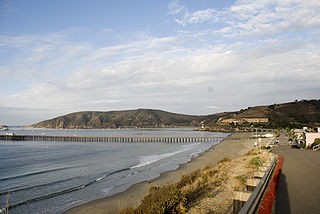
Avila Beach is an unincorporated community in San Luis Obispo County, California, United States, located on San Luis Obispo Bay about 160 miles (257 km) northwest of Los Angeles, and about 200 miles (320 km) south of San Francisco. The population was 1,576 at the 2010 census. For statistical purposes, the United States Census Bureau has defined Avila Beach as a census-designated place (CDP).

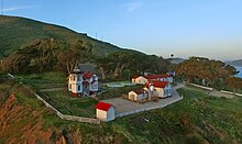
East Brother Island Lighthouse is a lighthouse located on East Brother Island in San Rafael Bay, near the tip of Point San Pablo in Richmond, California. It marks the entrance to San Pablo Bay from San Francisco Bay.

Kenosha Light Station is a lighthouse and keeper's house on Simmons Island north of the channel into Kenosha's harbor in Kenosha County, Wisconsin.

The original Point Loma Lighthouse is a historic lighthouse located on the Point Loma peninsula at the mouth of San Diego Bay in San Diego, California. It is situated within Cabrillo National Monument. It is no longer in operation as a lighthouse but is open to the public as a museum. It is sometimes erroneously called the "Old Spanish Lighthouse", but in fact it was not built during San Diego's Spanish or Mexican eras; it was built in 1855 by the United States government after California's admission as a state.

Alcatraz Island Lighthouse is a lighthouse—the first one built on the U.S. West Coast—located on Alcatraz Island in California's San Francisco Bay. It is located at the southern end of the island near the entrance to the prison. The first light house on the island was completed in 1854, and served the bay during its time as a Citadel and military prison. It was replaced by a taller concrete tower built in 1909 to the south of the original one which was demolished after it was damaged due to earthquake in 1906. The automation of the lighthouse with a modern beacon took place in 1963, the year Alcatraz closed as the Alcatraz Federal Penitentiary. It is the oldest light station on the island with a modern beacon and is part of the museum on the island. Although when viewed from afar it easily looks the tallest structure on Alcatraz, it is actually shorter than the Alcatraz Water Tower, but as it lies on higher ground it looks much taller.

Point Arena Light is a lighthouse in Mendocino County, California, United States, two miles (3 km) north of Point Arena, California. It is approximately 130 mi (210 km) north of San Francisco, in the Fort Point Group of lighthouses. The lighthouse features a small museum and gift shop. Guided tours of the light station as well as self-guided tours of the grounds are available daily.

Point Cabrillo Light is a lighthouse in northern California, United States, between Point Arena and Cape Mendocino, just south of the community of Caspar. It has been a federal aid to navigation since 1909. It is part of the California state park system as Point Cabrillo Light Station State Historic Park.

Point Hueneme Lighthouse is a lighthouse on the southeast entrance to the Santa Barbara Channel, in Ventura County, California

Roe Island Lighthouse was a lighthouse on Roe Island on the east end of Suisun Bay, California.

Table Bluff Lighthouse is a lighthouse in California, United States, which was located on Table Bluff just south of Humboldt Bay. Built to guide vessels away from the notoriously dangerous and rough coastline and to let them know proximity of the nearby bay and entrance, the lighthouse was one of the first to be automated. The lighthouse tower portion is now located at the Woodley Island Marina within the City of Eureka.

Concord Point Light is a 36-foot (11 m) lighthouse in Havre de Grace, Maryland. It overlooks the point where Susquehanna River flows into the Chesapeake Bay, an area of increasing navigational traffic when it was constructed in 1827. It is the northernmost lighthouse and the second-oldest tower lighthouse still standing on the bay.

The Dunkirk Lighthouse, also known as the Point Gratiot Light, is an active lighthouse located at Point Gratiot on Lake Erie in New York state.

Point Sur Lighthouse is a lightstation at Point Sur 24.6 miles (39.6 km) south of Monterey, California at the peak of the 361-foot (110 m) rock at the head of the point. It was established in 1889 and is part of Point Sur State Historic Park. The light house is 40 feet (12 m) tall and 270 feet (82 m) above sea level. As of 2016, and for the foreseeable future the light is still in operation as an essential aid to navigation.

The Makapuʻu Point Light on the island of Oʻahu has the largest lens of any lighthouse in the United States. It was listed on the National Register of Historic Places in 1977.

Piedras Blancas Light Station is located at Point Piedras Blancas, about 5.5 miles (8.9 km) west by northwest of San Simeon, California. It was added to the California Coastal National Monument in 2017.

The Port Washington Breakwater Light is a lighthouse built in 1935 at the entrance to the Port Washington, Wisconsin harbor on Lake Michigan. The second tower at this location, it remains an active aid to navigation. It was listed on the National Register of Historic Places in 2018.
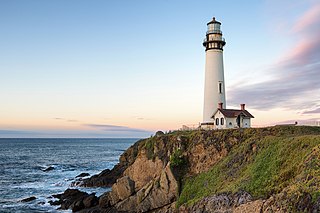
Pigeon Point Light Station or Pigeon Point Lighthouse is a lighthouse built in 1871 to guide ships on the Pacific coast of California. It is the tallest lighthouse on the West Coast of the United States. It is still an active Coast Guard aid to navigation. Pigeon Point Light Station is located on the coastal highway, 5 miles (8 km) south of Pescadero, California, between Santa Cruz and San Francisco. The 115-foot (35 m), white masonry tower, resembles the typical New England structure.
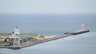
The Grand Marais Harbor of Refuge Inner and Outer Lights are a pair of lighthouses located on the west pier at the entry to Grand Marais Harbor of Refuge, in Grand Marais, Michigan. They were listed on the National Register of Historic Places in 2012.

Port San Luis is a harbor on the central coast of California, approximately 1.3 miles (2.1 km) west of Avila Beach in San Luis Obispo County. The harbor is managed by the Port San Luis Harbor District which is responsible for maintaining the surrounding tidelands and beaches. Originally acting as a major port for oil exports, the harbor serves as a recreational area and is used by boaters and researchers to study and appreciate the local marine life.