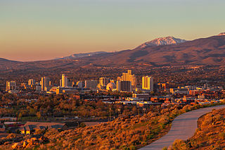
Reno is a city in the northwest section of the U.S. state of Nevada, along the Nevada–California border. It is the county seat and most populous city of Washoe County. Sitting in the High Eastern Sierra foothills, in the Truckee River valley, on the eastern side of the Sierra Nevada, it is about 23 miles (37 km) northeast of Lake Tahoe. Known as "The Biggest Little City in the World", Reno is the 80th most populous city in the United States, the fourth most populous city in Nevada, and the most populous in Nevada outside the Las Vegas Valley. The city had a population of 264,165 at the 2020 census.

Nevada County is a county located in the U.S. state of California, in the Sierra Nevada. As of the 2020 census, its population was 102,241. The county seat is Nevada City. Nevada County comprises the Truckee-Grass Valley micropolitan statistical area, which is also included in the Sacramento-Roseville combined statistical area, part of the Mother Lode Country.

Placer County, officially the County of Placer, is a county located in the U.S. state of California. As of the 2020 census, the population was 404,739. The county seat is Auburn.
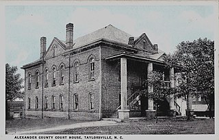
Alexander County is a county established in the U.S. state of North Carolina in 1847. As of the 2020 census, the population was 36,444. Its county seat is Taylorsville. Alexander County is part of the Hickory-Lenoir-Morganton, NC Metropolitan Statistical Area.

Truckee is an incorporated town in Nevada County, California, United States. As of the 2010 United States Census, the population was 16,180, reflecting an increase of 2,316 from the 13,864 counted in the 2000 Census.
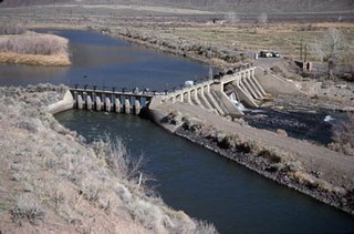
Derby Dam is a diversion dam built from 1903 to 1905 on the Truckee River, located about 20 miles (32 km) east of Reno in Storey and Washoe counties in Nevada, United States. It diverts water into the Truckee Canal that would otherwise enter Pyramid Lake. The canal feeds Lake Lahontan reservoir in the Carson River watershed, where it is used for irrigation.

The Truckee River is a river in the U.S. states of California and Nevada. The river flows northeasterly and is 121 miles (195 km) long. The Truckee is the sole outlet of Lake Tahoe and drains part of the high Sierra Nevada, emptying into Pyramid Lake in the Great Basin. Its waters are an important source of irrigation along its valley and adjacent valleys.

Donner Lake, formerly known as Truckee Lake, is a freshwater lake in Northeast California on the eastern slope of the Sierra Nevada and about 20 miles (32 km) northwest of the much larger Lake Tahoe. A moraine serves as a natural dam for the lake. The lake is located in the town of Truckee, between Interstate 80 to the north and Schallenberger Ridge to the south. The tracks of the Union Pacific Railroad run along Schallenberger Ridge and closely follow the route of the original transcontinental railroad. The historic route of the Lincoln Highway, the first automobile road across America and US 40 follows the northern shoreline, then climbs to Donner Pass from where the entire lake may be viewed.
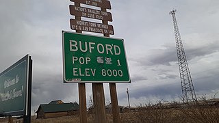
Buford is an unincorporated community in Albany County, Wyoming, United States. It is located between Laramie and Cheyenne on Interstate 80. Its last resident, who had been the lone resident for nearly two decades, left in 2012. As of the 2020 US Census, the population of the community is 0.

Lahontan cutthroat trout is the largest subspecies of cutthroat trout and the state fish of Nevada. It is one of three subspecies of cutthroat trout that are listed as federally threatened.

Sarah Clark Kidder was president of Northern California's Nevada County Narrow Gauge Railroad (NCNGRR) from 1901 to 1913. She was the first female railroad president in the world.

Sugar Bowl is a ski and snowboard area in northern Placer County near Norden, California along the Donner Pass of the Sierra Nevada, approximately 46 mi (74 km) west of Reno, Nevada on Interstate 80, that opened on December 15, 1939. Sugar Bowl is a medium-sized ski area in the Lake Tahoe region, and is well known for its long history, significant advanced terrain, high annual snowfall and being one of the closest ski areas to the San Francisco Bay Area. Sugar Bowl's terrain is 17% Beginner, 45% Intermediate and 38% Advanced.
Chicago Park is a residential and unincorporated historic agricultural community in Nevada County, California. It is located along Highway 174, with its center at the intersection of Mt. Olive Road. The neighborhood gets its name from its founding residents, who came from Chicago to California in the late 1800s to grow fruit, which was often shipped back to Illinois for consumption. Chicago Park is about 9 miles southeast of Grass Valley and about 3 miles north of Colfax.
Boca is a former settlement in Nevada County, California. Situated at an elevation of 5,528 ft (1,685 m) above sea level, Boca is located on the Southern Pacific Railroad, 6.5 miles (10.5 km) northeast of Truckee at exit 194 from Interstate 80 onto Hirschdale Road.
Maybert was a mining town in Nevada County, California. It was located on the south side of the South Yuba River, about 6 miles east of the town of Washington, at an elevation of 3,245 ft (989 m). Fall Creek empties into the South Yuba slightly to the northwest of the town site.
Iceland, once known as Cuba, was an ice farming and lumbering community in eastern Nevada County, California. It was located between Boca, California and the Nevada state line, about 1 1/2 miles south of Floriston, California and 9 miles east of Truckee, California. It lay near where Gray Creek flows into the Truckee River.
Brockway is an unincorporated community in Placer County, California. Brockway is located on the north shore of Lake Tahoe on State Line Point, adjacent to the Nevada state border. It lies at an elevation of 6266 feet.

Trout Creek is a small tributary of the Truckee River draining about 5.1 square miles (13 km2) along the eastern crest of the Sierra Nevada. It originates east of Donner Ridge and north of Donner Lake in the Tahoe–Donner Golf Course and flows through the town of Truckee, California, to its confluence with the Truckee River in Nevada County, California, just west of Highway 267.
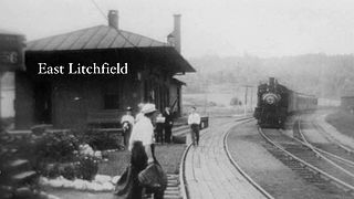
East Litchfield is an unincorporated village in the town of Litchfield, Litchfield County, Connecticut, United States.
The Trout Creek Outrage, also known as the Truckee Outrage or Trout Creek Murder, was an example of anti-Chinese violence in California which occurred on the night of June 17–18, 1876. White residents of Truckee, California set fire to two cabins along Trout Creek that housed six Chinese immigrants working as woodcutters approximately 2 mi (3.2 km) northwest of the town; as the woodcutters fled the fires, the Truckee men shot them, killing one and wounding another. Seven men were arrested two months later and tried for arson and murder in September 1876, but the lone defendant for the murder charge was found not guilty by an all-white jury after nine minutes of deliberation, and the arson charges against the men were dismissed. Ten years later in 1886, the citizens of Truckee succeeded in driving the last Chinese immigrants from the city, which previously had been the home of the second-largest Chinatown in the western United States.


