Vanderpool is a small unincorporated community in Bandera County in the Texas Hill Country, United States, which is part of the Edwards Plateau. It is considered part of the San Antonio Metropolitan Statistical Area. Although it is unincorporated, Vanderpool has a post office, with the ZIP code of 78885. According to the Handbook of Texas, Vanderpool had a population of 22 in 1990. Hunting, ranching and tourism are prime contributors to the regional economy.

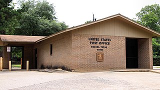
Neches is an unincorporated community and census designated place (CDP) in east central Anderson County, in the U.S. state of Texas. According to the Handbook of Texas, the community had a population of 175 in 2000. It is located within the Palestine, Texas micropolitan area.
Mumford is an unincorporated community in Robertson County, Texas, United States. It is part of the Bryan-College Station metropolitan area. Mumford is unincorporated and has no post office, with the ZIP code of 77867; the ZCTA for ZIP Code 77867 had a population of 176 at the 2000 census.

Star is an unincorporated community in Mills County in Central Texas, United States. According to the Handbook of Texas, the community had an estimated population of 85 in 2000.
May is an unincorporated community in Brown County, Texas, United States. According to the Handbook of Texas, the community had an estimated population of 285 in 2000. May was designated a Recorded Texas Historic Landmark in 1981, with marker number 5377. In 2001, historical marker 12532 was added for May United Methodist Church, commemorating the church's presence in the community for over 100 years. The May Cemetery was designated a Historic Texas Cemetery in 2016.
Medina is an unincorporated community in Bandera County, Texas, United States. It is part of the San Antonio Metropolitan Statistical Area. Medina is famous for its apples. The community's population was estimated to be 515 in 2000.
Jonesboro is an unincorporated community in Coryell and Hamilton counties in Central Texas, United States. The Coryell County portion of the community is part of the Killeen–Temple–Fort Hood Metropolitan Statistical Area.
Montalba is an unincorporated community in central Anderson County, Texas, United States. According to the Handbook of Texas, the community had a population of 809 in 2019. It is located within the Palestine, Texas micropolitan area.

Hye is an unincorporated community in western Blanco County, Texas, United States. According to the Handbook of Texas, the community had a population of 105 in 2000. Hye is part of the Texas-German belt and in very conservative rural Texas.

McNeil is an unincorporated community in Travis County, Texas, United States. According to the Handbook of Texas, the community had a population of 70 in 2000. It is located within the Greater Austin Metropolitan area. Its elevation is 830 feet (253 m).

Kenney is an unincorporated community in northern Austin County, Texas, United States. According to the Handbook of Texas, the community had a population of 200 in 2000. It is located within the Greater Houston metropolitan area.

Cat Spring is an unincorporated community in southern Austin County, Texas, United States. According to the Handbook of Texas, it had a population of 76 in 2000. Cat Spring was one of the first German/American settlements in Texas, and the location of Texas' first agricultural society.
Waka is an unincorporated community in western Ochiltree County, Texas, United States. It lies along State Highway 15 southwest of the city of Perryton, the county seat of Ochiltree County. Its elevation is 3,045 feet (928 m). Although Waka is unincorporated, it has a post office, with the ZIP code of 79093; the ZCTA for ZIP code 79093 had a population of 76 at the 2000 census.

Heidenheimer is an unincorporated community in Bell County, Texas, United States. According to the Handbook of Texas, the community had an estimated population of 144 in 2000. The community is part of the Killeen–Temple–Fort Hood Metropolitan Statistical Area.
Campbellton is an unincorporated community in Atascosa County, Texas, United States. According to the Handbook of Texas, the community had an estimated population of 350 in 2000. Campbellton is part of the San Antonio Metropolitan Statistical Area.
Flomot is an unincorporated community in Motley County, Texas, United States. According to the Handbook of Texas, the community had an estimated population of 181 in 2000.
Garwood is an unincorporated community and census designated place (CDP) in Colorado County, Texas, United States. According to the Handbook of Texas, the community had a population of 975 in 2000.
Enochs is an unincorporated community in Bailey County, Texas, United States. According to the Handbook of Texas, the community had an estimated population of 80 in 2000. Enochs has a post office, with the ZIP code of 79324.

Fischer is an unincorporated community in Comal County, Texas, United States. According to the Handbook of Texas, the community had a population of 20 in 2000. It is included in the Greater San Antonio area.
Oakland is an unincorporated community in Colorado County, Texas, United States. According to the Handbook of Texas, the community had an estimated population of 80 in 2000.


