Power House Covered Bridge | |
|---|---|
 Bridge in U.S. state of Vermont | |
| Coordinates | 44°38′10″N72°40′14″W / 44.6361°N 72.6706°W |
| Carries | Automobile |
| Crosses | Gihon River |
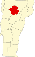
| Locale | Johnson, Vermont |
| Maintained by | Town of Johnson |
| ID number | VT-08-08 |
| Characteristics | |
| Design | Covered, Queen post |
| Material | Wood |
| Total length | 63 ft (19.20 m) |
| Width | 14 ft (4.27 m) |
| No. of spans | 1 |
| Load limit | 8 tons |
| Clearance above | 8.75 ft (2.67 m) |
| History | |
| Constructed by | unknown |
| Construction end | 1870 |
  | |
| Coordinates | 44°38′10″N72°40′14″W / 44.63611°N 72.67056°W |
| Area | 1 acre (0.4 ha) |
| NRHP reference No. | 74000231 [1] |
| Added to NRHP | October 9, 1974 |
The Power House Covered Bridge, also known as the School Street Covered Bridge, [2] is a covered bridge from 1872 that crosses the Gihon River off State Route 100C in Johnson, Vermont, US. It was listed on the National Register of Historic Places in 1974. [1] The bridge's name is from a now obsolete hydroelectric generating station just upstream from it. The bridge is of Queen post truss design by an unknown builder.