
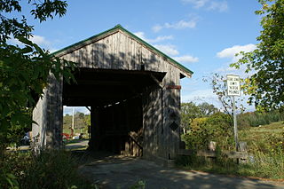
Gold Brook Covered Bridge, also known as Stowe Hollow Bridge or Emily's Bridge, is a small wooden covered bridge in the town of Stowe, Lamoille County, Vermont, carrying Covered Bridge Road over Gold Brook. Built in 1844, it is the only 19th-century covered bridge in the state built using wooden Howe trusses and carrying a public roadway. It was added to the National Register of Historic Places in 1974.

The Power House Covered Bridge, also known as the School Street Covered Bridge, is a covered bridge from 1872 that crosses the Gihon River off State Route 100C in Johnson, Vermont, US. It was listed on the National Register of Historic Places in 1974. The bridge's name is from a now obsolete hydroelectric generating station just upstream from it. The bridge is of Queen post truss design by an unknown builder.
The Scribner Covered Bridge, also known as the Mudgett Covered Bridge, is a covered bridge that carries Rocky Road across the Gihon River off State Route 100C in eastern Johnson, Vermont. It was listed on the National Register of Historic Places in 1974. It is one of a small number of Vermont's covered bridges that are the result of covering an existing open bridge.

The Braley Covered Bridge, also called the Johnson Covered Bridge and Upper Blaisdell Covered Bridge, is a wooden covered bridge that crosses the Second Branch of the White River in Randolph, Vermont on Braley Covered Bridge Road. It was listed on the National Register of Historic Places in 1974. The bridge was built in 1904 as an uncovered kingspost truss bridge, and was covered in 1909.
The Gifford Covered Bridge, also called the C.K. Smith Covered Bridge, is a wooden covered bridge that crosses the Second Branch of the White River in Randolph, Vermont on Hyde Road. It was listed on the National Register of Historic Places in 1974. It is one of two bridges in the state that was uncovered when first built, its trusses boxed for shelter.

The Stony Brook Covered Bridge, also called the Moseley Covered Bridge, is a wooden covered bridge that crosses Stony Brook in Northfield, Vermont on Stony Brook Road. Built in 1899, it is one of two surviving 19th-century King post truss bridges in the state. It was listed on the National Register of Historic Places in 1974.
The Northfield Falls Covered Bridge, also called the Station Covered Bridge, is a wooden covered bridge that carries Cox Brook Road across the Dog River in Northfield, Vermont. Built in 1872, this Town lattice truss bridge is one of five surviving covered bridges in the town, and one of two that are visible from each other. It was listed on the National Register of Historic Places in 1974.

The Slaughter HouseCovered Bridge is a wooden covered bridge that carries Slaughterhouse Road across the Dog River in Northfield, Vermont. The Queen post truss bridge is one of five surviving 19th-century bridges in the town. It was listed on the National Register of Historic Places in 1974.

The Lower Cox Brook Covered Bridge is a wooden covered bridge that crosses Cox Brook in Northfield, Vermont on Cox Brook Road. Built in 1872, it is one of five surviving 19th-century covered bridges in the town, in the only place in Vermont where two historic bridges are visible from each other. It was listed on the National Register of Historic Places in 1974.

The Pine Brook Covered Bridge, also called the Wilder Covered Bridge, is a wooden covered bridge that crosses Pine Brook in Waitsfield, Vermont on North Road. Built in 1872, it is one two surviving 19th-century covered bridges in the town. It was listed on the National Register of Historic Places in 1974.

The Hutchins Covered Bridge is a wooden covered bridge that crosses the South Branch of the Trout River in Montgomery, Vermont on Hutchins Bridge Road. It was built in 1883 by Sheldon & Savannah Jewett, brothers who are credited with building most of the area's covered bridges. It was listed on the National Register of Historic Places in 1974.

The Mill Covered Bridge is a wooden covered bridge that crosses the North Branch Lamoille River on Back Road in Belvidere, Vermont. Built about 1890, it is one of two surviving covered bridges in the rural community. It was listed on the National Register of Historic Places in 1974.

The Morgan Covered Bridge, also known as the Upper Covered Bridge is a wooden covered bridge that crosses the North Branch Lamoille River in Belvidere, Vermont on Morgan Bridge Road. Built about 1887, it is one of two covered bridges in Belvidere, and one of five in a five-mile span that all cross the same river. It was listed on the National Register of Historic Places in 1974.

The Montgomery Covered Bridge, also known as the Lower Covered Bridge is a wooden covered bridge that carries Montgomery Road across the North Branch of the Lamoille River in Waterville, Vermont. Built in 1887, it is one of three covered bridges in the town, and one of five on the river in a five-mile span. It was listed on the National Register of Historic Places in 1974.

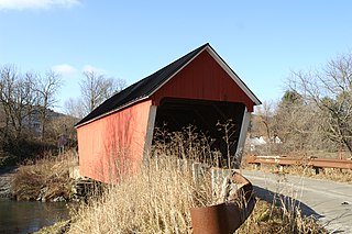
The Waterman Covered Bridge was an historic covered bridge in Johnson, Vermont that carried Waterman Road across Waterman Creek. Built in 1868, it was one of three surviving 19th-century bridges in the town. It was listed on the National Register of Historic Places in 1974, and collapsed in January 1982.

The Fisher Covered Railroad Bridge is a covered bridge in Wolcott, Vermont. Built in 1908, it originally carried the St. Johnsbury and Lamoille County Railroad line over the Lamoille River. Now closed, it was the last covered bridge in Vermont to carry railroad traffic, and is a rare surviving example in the state of a double Town lattice truss. It was listed on the National Register of Historic Places in 1974.

The East Shoreham Covered Railroad Bridge is a historic covered bridge spanning the Lemon Fair River near East Shoreham, Vermont. Built in 1897 by the Rutland Railroad Company, it is the state's only surviving example of a wooden Howe truss railroad bridge. It was listed on the National Register of Historic Places in 1974.

The Jaynes Covered Bridge is a historic covered bridge, carrying Codding Hollow Road across the North Branch Lamoille River in Waterville, Vermont. Built in 1877, it is one of three 19th-century covered bridges in the town, and one of five to span the North Branch Lamoille in a five-mile span. It was listed on the National Register of Historic Places in 1974.

The Jeffersonville Bridge is a steel girder bridge carrying Vermont Route 108 across the Lamoille River, just north of the village of Jeffersonville, Vermont. It was built in 2014, replacing a Parker through truss bridge built in 1931; the latter bridge was listed on the National Register of Historic Places in 1991.

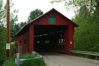
The Red Covered Bridge is a historic covered bridge, carrying Cole Hill Road across Sterling Brook in Morristown, Vermont. Built in 1896, it is the only surviving 19th-century covered bridge in the town, and one of the last to be built during the historic period of covered bridge construction in the state. It is of queen post truss design, and was listed on the National Register of Historic Places in 1974.


