Powerhouse Arts District, Jersey City

Last updated

The Powerhouse Powerhouse yellow doors fr HBLR crop jeh.jpg
The Powerhouse

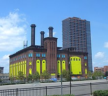
The Powerhouse Arts District is a historic warehouse district in Downtown Jersey City, New Jersey, United States, on the water front of the Hudson River. Its name derives from the unused generating station Hudson and Manhattan Railroad Powerhouse, [1] [2] [3] a historic Victorian-era power plant that was renovated into an arts center. [4] The area was once home to large industrial operations, which gradually left the district during the 20th century, leaving large derelict buildings that attracted artists drawn to the large, affordable loft spaces. [3]

Contents

WALDO and PAD

The A & P Warehouse Great-a-p-warehouse-jersey-city.jpg
The A & P Warehouse

Most of the proposals for retail and gallery space never materialized or found tenants, and as a result the eight blocks of industrial buildings remain much the same as in 2002 when the district began. As well, the city approved new zoning for a large development on First Street which deviated from the district plan. New zoning was proposed for several other blocks. Most proposed developments were higher rise structures, and the majority of capital investment in the district favors high rise development. These factors led to WALDO (Work And Live District Overlay) being removed from the zoning ordinance. [5]

See also

Related Research Articles

<span class="mw-page-title-main">SoHo, Manhattan</span> Neighborhood in Manhattan, New York

SoHo, is a neighborhood in Lower Manhattan, New York City. Since the 1970s, the neighborhood has been the location of many artists' lofts and art galleries, and has also been known for its variety of shops ranging from trendy upscale boutiques to national and international chain store locations. The area's history is an archetypal example of inner-city regeneration and gentrification, encompassing socioeconomic, cultural, political, and architectural developments.

<span class="mw-page-title-main">Chelsea, Manhattan</span> Neighborhood of Manhattan in New York City

Chelsea is a neighborhood on the West Side of the borough of Manhattan in New York City. The area's boundaries are roughly 14th Street to the south, the Hudson River and West Street to the west, and Sixth Avenue to the east, with its northern boundary variously described as near the upper 20s or 34th Street, the next major crosstown street to the north. To the northwest of Chelsea is the neighborhood of Hell's Kitchen, as well as Hudson Yards; to the northeast are the Garment District and the remainder of Midtown South; to the east are NoMad and the Flatiron District; to the southwest is the Meatpacking District; and to the south and southeast are the West Village and the remainder of Greenwich Village. Chelsea is named after the Royal Hospital Chelsea in London, England.

<span class="mw-page-title-main">Dumbo, Brooklyn</span> Neighborhood in New York City

Dumbo is a neighborhood in the New York City borough of Brooklyn. It encompasses two sections: one situated between the Manhattan and Brooklyn Bridges, which connect Brooklyn to Manhattan across the East River, and another extending eastward from the Manhattan Bridge to the Vinegar Hill area. The neighborhood is bounded by Brooklyn Bridge Park to the north, the Brooklyn Bridge to the west, Brooklyn Heights to the south, and Vinegar Hill to the east. Dumbo is part of Brooklyn Community Board 2.

<span class="mw-page-title-main">Newport, Jersey City</span> Populated place in Hudson County, New Jersey, US

Newport is a 600-acre (2.4 km2) master-planned, mixed-use community in Downtown Jersey City, in the U.S. state of New Jersey, consisting of retail, residential, office, and entertainment facilities. The neighborhood is situated on the Hudson Waterfront. Prior to development, the area was home to the Erie Railroad's Pavonia Terminal. The area is located opposite Lower Manhattan and theTribeca neighborhood in New York City. Redevelopment of Newport began in 1986 as a $10 billion project led by real-estate tycoon Samuel J. LeFrak and his firm The LeFrak Organization.

<span class="mw-page-title-main">West Village</span> Neighborhood of Manhattan in New York City

The West Village is a neighborhood in the western section of the larger Greenwich Village neighborhood of Lower Manhattan, New York City. The West Village is bounded by the Hudson River to the west and 14th Street to the north. The eastern boundary is variously cited as Greenwich Avenue, Seventh Avenue, or Sixth Avenue, while the southern boundary is either Houston Street or Christopher Street.

<span class="mw-page-title-main">Port Morris, Bronx</span> Neighborhood of the Bronx in New York City

Port Morris is a mixed use, primarily industrial neighborhood geographically located in the southwest Bronx, New York City. The neighborhood is part of Bronx Community Board 1. Its boundaries are the Major Deegan Expressway and Bruckner Expressway to the north, East 149th Street to the east, the East River to the southeast, the Bronx Kill to the south, and the Harlem River to the west. Its ZIP Codes are 10451 and 10454. The neighborhood is served by the NYPD's 40th Precinct.

<span class="mw-page-title-main">Western Slope, Jersey City</span> Populated place in Hudson County, New Jersey, US

Western Slope is a neighborhood in The Heights, Jersey City, New Jersey on the cuesta, or gradual decline, of the western side of the New Jersey Palisades between The Boulevard and Tonnele Avenue.

<span class="mw-page-title-main">Downtown Jersey City</span> Populated place in Hudson County, New Jersey, US

Downtown is an area of Jersey City, New Jersey, which includes the Historic Downtown and the Waterfront.

<span class="mw-page-title-main">Hudson River Waterfront Walkway</span> Park in the United States of America

The Hudson River Waterfront Walkway, also known as the Hudson River Walkway, is a promenade along the Hudson Waterfront in New Jersey. The ongoing and incomplete project located on Kill van Kull and the western shore of Upper New York Bay and the Hudson River was implemented as part of a New Jersey state-mandated master plan to connect the municipalities from the Bayonne Bridge to the George Washington Bridge with an urban linear park and provide contiguous unhindered access to the water's edge.

<span class="mw-page-title-main">Harsimus Stem Embankment</span> Railroad embankment in New Jersey, US

The Harsimus Stem Embankment, also called Sixth Street Embankment, is a half-mile-long historic railroad embankment, disused and largely overgrown with foliage, in the heart of the historic downtown of Jersey City, New Jersey in the United States. The 27-foot-high (8.2 m) embankment runs along the south side of Sixth Street west from Marin Boulevard to Brunswick Street. It is the border between the Harsimus and Hamilton Park neighborhoods. The overhead tracks of the beam bridge west of Brunswick Street were dismantled but the stone abutments remain.

<span class="mw-page-title-main">Great Atlantic and Pacific Tea Company Warehouse</span> United States historic place

The Great Atlantic and Pacific Tea Company Warehouse is a historic formerly commercial building at 150 Bay Street in Jersey City, Hudson County, New Jersey, United States. Built as a warehouse for The Great Atlantic & Pacific Tea Company (A&P) in 1900, it is the major surviving remnant of a five-building complex of the nation's first major grocery store chain. It was designated a National Historic Landmark in 1978, and now houses a mix of residences and storage facilities.

111 First Street was an industrial building in Jersey City, New Jersey, at the intersection of First and Washington Streets in Downtown Jersey City. Prior to its demolition in 2007, the 19th-century industrial building on the site had been converted to an arts center, artists' residence, and loft. As of 2018, the site is the location of a proposed 52-story skyscraper.

<span class="mw-page-title-main">Hudson and Manhattan Railroad Powerhouse</span> United States historic place

The Hudson and Manhattan Railroad Powerhouse, also known as the Jersey City Powerhouse in Jersey City, Hudson County, New Jersey, United States, was built in 1908. The powerhouse made possible the subway system between New Jersey and New York for the Hudson and Manhattan Railroad. It was built under the leadership of William Gibbs McAdoo, president of the railroad. The powerhouse was closed in 1929 and used as a storage place for railroad equipment. In the 1990s, the building was cited by Preservation New Jersey as one of the state's ten most endangered historic sites. The powerhouse was added to the National Register of Historic Places on November 23, 2001, for its significance in architecture, engineering, and transportation.

<span class="mw-page-title-main">Harsimus</span> Populated place in Hudson County, New Jersey, US

Harsimus is a neighborhood within Downtown Jersey City, Hudson County, in the U.S. state of New Jersey. The neighborhood stretches from the Harsimus Stem Embankment on the north to Christopher Columbus Drive on the south between Coles Street and Grove Street or more broadly, to Marin Boulevard. It borders the neighborhoods of Hamilton Park to the north, Van Vorst Park to the south, the Village to the west, and the Powerhouse Arts District to the east. Newark Avenue has traditionally been its main street. The name is from the Lenape, used by the Hackensack Indians who inhabited the region and could be translated as Crow's Marsh. From many years, the neighborhood was part of the "Horseshoe", a political delineation created by its position between the converging rail lines and political gerrymandering.

<span class="mw-page-title-main">Van Vorst Park</span> Populated place in Essex County, New Jersey, US

Van Vorst Park is a neighborhood in the Historic Downtown of Jersey City, Hudson County, New Jersey, centered on a park sharing the same name. The neighborhood is located west of Paulus Hook and Marin Boulevard, north of Grand Street, east of the Turnpike Extension, and south of The Village and Christopher Columbus Drive. Much of it is included in the Van Vorst Park Historical District.

Bergen-Lafayette is a section of Jersey City, New Jersey.

<span class="mw-page-title-main">West Side, Jersey City</span> Populated place in Hudson County, New Jersey, US

The West Side of Jersey City is an area made up of several diverse neighborhoods on either side of West Side Avenue, one of the city's main shopping streets. Parallel and west of Kennedy Boulevard, West Side Avenue carries two county route designations.

<span class="mw-page-title-main">Hilltop, Jersey City</span> Populated place in Hudson County, New Jersey, US

The Hilltop is the eastern section of the Journal Square district of Jersey City, New Jersey. The name is a reflection of its location atop Bergen Hill, the southern portion of the Hudson Palisades, on either side of the cut, or excavated ravine, through which the Port Authority Trans Hudson rapid transit system travels, offering some streets views of Downtown Jersey City, the New York Skyline, and the Upper New York Bay.

<span class="mw-page-title-main">Bergen Hill, Jersey City</span> Populated place in Hudson County, New Jersey, US

Bergen Hill is the name given to the emergence of the Hudson Palisades along the Bergen Neck peninsula in Hudson County, New Jersey and the inland neighborhood of Jersey City, New Jersey, where they rise from the coastal plain at the Upper New York Bay. The name is taken from the original 17th-century New Netherland settlement of Bergen, which in Dutch means hills.

<span class="mw-page-title-main">Canal Crossing, Jersey City</span> Populated place in Hudson County, New Jersey, US

Canal Crossing is a New Urbanism project on the eastern side of Jersey City, New Jersey between Jackson Hill in Greenville/Bergen-Lafayette and Liberty State Park. The approximately 111-acre (45 ha) area, previously designated for industrial and distribution uses has been re-zoned for transit-oriented residential and commercial use and the construction of a neighborhood characterized as a sustainable community. The name is inspired by the Morris Canal, which once traversed the district in a general north and south alignment. The brownfield site must first undergo remediation of toxic waste, much of it left by PPG Industries The redevelopment plans call for 7,000 housing units, mainly "mid-rise" buildings, and a greenway along the former canal, directly south of the 17-acre (6.9 ha) Berry Lane Park.

References

  1. "Warehouse Historic District". Jersey City Landmarks Conservancy. 2007. Archived from the original on June 11, 2008.
  2. "Jersey City Powerhouse Official Website". City of Jersey City. Archived from the original on March 9, 2021. Retrieved April 13, 2016.
  3. 1 2 Whiten, Jon; Hunger Matt (Winter 2011). "Neighborhood Spotlight: The Powerhouse Arts District". NEW Magazine. Archived from the original on October 31, 2014. Retrieved April 13, 2016 via Jersey City Independent.{{cite web}}: CS1 maint: multiple names: authors list (link)
  4. Martin, Antoinette (March 4, 2007). "The Hanging Tower of Jersey City". The New York Times . Retrieved June 14, 2021.
  5. Applebome, Peter (May 15, 2008). "Adjusting Vision of Waterfront Arts District to Include High Rises". The New York Times . Archived from the original on March 11, 2016. Retrieved June 14, 2021.

40°43′12″N74°02′20″W / 40.7199°N 74.0389°W / 40.7199; -74.0389