Prestolee

Last updated

Prestolee
Prestolee aqueduct panorama.jpg
Greater Manchester UK location map 2.svg
Red pog.svg
Prestolee
Location within Greater Manchester
OS grid reference SD754057
Metropolitan borough
Metropolitan county
Region
Country England
Sovereign state United Kingdom
Post town MANCHESTER
Postcode district M26
Dialling code 01204
Police Greater Manchester
Fire Greater Manchester
Ambulance North West
UK Parliament
List of places
UK
England
Greater Manchester
53°32′49″N2°22′12″W / 53.547°N 2.370°W / 53.547; -2.370

Prestolee is a small village in Kearsley, within the Metropolitan Borough of Bolton, in Greater Manchester, England. It lies on the River Irwell and is one of a cluster of villages between Bolton and Kearsley, which includes Stoneclough and Ringley.

Historically part of Lancashire, during the Middle Ages, Prestolee was a chapelry within the ancient ecclesiastical parish of Prestwich-cum-Oldham.

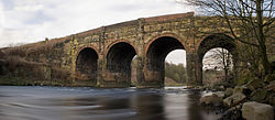
Prestolee is surrounded almost completely by water and is effectively an island, with the River Irwell to the north, west and south and the Manchester, Bolton & Bury Canal to the northeast. There is one road (Bridge Street) that provides vehicle access over the River Irwell. Prestolee Road also allows access to the village via a small canal bridge but the road is not metalled and not practical for most vehicles. Pedestrian access from the north is facilitated by using Prestolee Aqueduct, or the nearby Pack Horse Bridge.

Many countryside walks radiate from Prestolee with particular focus upon the industrial heritage of this region. Not long ago the area was severely damaged by pollution but with the coming of the Clean Air Act and the demise of the cotton mills the river has once again regained its fish and other wildlife and wild flowers abound.

It has a church (Holy Trinity) that was used by TV show Coronation Street as a venue for many weddings and known to fans as All Saints' Church, Weatherfield. It also has a primary school.

As well as the church, its other major landmark is Kearsley Mill, a cotton spinning mill in its previous guise, now home to several industrial uses. At one time there were also two other mills located on the banks of the Irwell to the right of the road bridge from Stoneclough, though these mills were demolished in the 1970s to make way for housing. Prestolee has various shops in or just outside the village, including a greengrocer's, a chip shop (now a takeaway) and a sweet shop later becoming a butcher's before ending as a village community centre. There is a pub, the Grapes Hotel, to the Stoneclough end of the bridge and several others in the near vicinity.

Prestolee has a small primary school. There is a fascinating book about the history of Prestolee school, which was run for very many years by Edward O'Neill, who believed children should be self-directed in their education. The book is called The Idiot Teacher and is by Gerard Holmes. It's particularly interesting because some experimental schools of this type such as Dartington were famous, whereas this school was ordinary, not fee-paying and not famous, but just as revolutionary.

Related Research Articles

<span class="mw-page-title-main">Manchester Bolton & Bury Canal</span> Canal in Greater Manchester, England

The Manchester Bolton & Bury Canal is a disused canal in Greater Manchester, England, built to link Bolton and Bury with Manchester. The canal, when fully opened, was 15 miles 1 furlong (24 km) long. It was accessed via a junction with the River Irwell in Salford. Seventeen locks were required to climb to the summit as it passed through Pendleton, heading northwest to Prestolee before it split northwest to Bolton and northeast to Bury. Between Bolton and Bury the canal was level and required no locks. Six aqueducts were built to allow the canal to cross the rivers Irwell and Tonge and several minor roads.

<span class="mw-page-title-main">Bury, Greater Manchester</span> Market town in Greater Manchester, England

Bury is a market town on the River Irwell in the Metropolitan Borough of Bury, Greater Manchester, England. which had a population of 81,101 in 2021 while the wider borough had a population of 193,846.

<span class="mw-page-title-main">Castlefield</span> Human settlement in England

Castlefield is an inner-city conservation area in Manchester, North West England. The conservation area which bears its name is bounded by the River Irwell, Quay Street, Deansgate and Chester Road. It was the site of the Roman era fort of Mamucium or Mancunium which gave its name to Manchester. It was the terminus of the Bridgewater Canal, the world's first industrial canal, built in 1764; the oldest canal warehouse opened in 1779. The world's first passenger railway terminated here in 1830, at Liverpool Road railway station and the first railway warehouse opened here in 1831.

<span class="mw-page-title-main">Farnworth</span> Human settlement in England

Farnworth is a town in the Metropolitan Borough of Bolton, Greater Manchester, England, 2 miles (3.2 km) southeast of Bolton, 4 miles south-west of Bury (7 km), and 8 miles (12.9 km) northwest of Manchester.

<span class="mw-page-title-main">River Irwell</span> River in Lancashire, United Kingdom

The River Irwell is a tributary of the River Mersey in north west England. It rises at Irwell Springs on Deerplay Moor, approximately 1+12 miles north of Bacup and flows southwards for 39 mi (63 km) to meet the Mersey near Irlam. The Irwell marks the boundary between Manchester and Salford, and its lower reaches have been canalised and now form part of the Manchester Ship Canal.

<span class="mw-page-title-main">Radcliffe, Greater Manchester</span> Town in Greater Manchester, England

Radcliffe is a market town in the Metropolitan Borough of Bury, Greater Manchester, England. It lies in the Irwell Valley 7 miles (11 km) northwest of Manchester and 3 miles (5 km) southwest of Bury and is contiguous with Whitefield to the south. The disused Manchester Bolton & Bury Canal bisects the town.

<span class="mw-page-title-main">Pendlebury</span> Town in Greater Manchester, England

Pendlebury is a town in the City of Salford, Greater Manchester, England. The population at the 2011 Census was 13,069. It lies 4 miles (6 km) north-west of Manchester, 3 miles (5 km) north-west of Salford and 6 miles (10 km) south-east of Bolton.

<span class="mw-page-title-main">Little Lever</span> Village in Greater Manchester, England

Little Lever is a village in the Metropolitan Borough of Bolton, Greater Manchester, England. Within the Historic County of Lancashire, it is 2 miles (3.2 km) southeast of Bolton, 2 miles (3.2 km) west of Radcliffe and 4 miles (6.4 km) southwest of Bury. In the 19th century, the population was employed in cotton mills, paper mills, bleach works, terracotta works, a rope works and numerous collieries.

<span class="mw-page-title-main">Kearsley railway station</span> Railway station in Greater Manchester, England

Kearsley railway station serves the town of Kearsley and the outlying villages of Stoneclough, Prestolee and Ringley in Greater Manchester, England. It was originally named Stoneclough.

<span class="mw-page-title-main">Clifton, Greater Manchester</span> Suburb in Greater Manchester

Clifton is a suburb of Swinton in the City of Salford in Greater Manchester, England. It lies along the edge of Irwell Valley in the north of the City of Salford. Historically in Lancashire, it was a centre for coal mining, and once formed part of the Municipal Borough of Swinton and Pendlebury.

<span class="mw-page-title-main">Kearsley</span> Town in Bolton, Greater Manchester, England

Kearsley is a town in the Metropolitan Borough of Bolton, Greater Manchester, England. The population at the 2011 census was 14,212. Within the Historic County of Lancashire, it lies 8 miles (13 km) northwest of Manchester, 5 miles (8 km) southwest of Bury and 3+34 miles (6 km) south of Bolton.

<span class="mw-page-title-main">Waterfoot, Lancashire</span> Human settlement in England

Waterfoot is a historic mill town and civil parish in the Borough of Rossendale between Rawtenstall and Bacup in Lancashire, England. The B6238 road from Burnley meets the A681 road, and Whitewell Brook the River Irwell.

<span class="mw-page-title-main">Stoneclough</span> Human settlement in England

Stoneclough is a suburban area of Kearsley in the Metropolitan Borough of Bolton, Greater Manchester, England. It is located 3.7 miles (6 km) south-east of Bolton, 4 miles (6 km) south-west of Bury and 7.9 miles (13 km) north-west of Manchester. It is located on the banks of the River Irwell to the southeast of Bolton.

<span class="mw-page-title-main">Prestolee Aqueduct</span> Bridge in Prestolee, Greater Manchester

Prestolee Aqueduct is a stone-built aqueduct in Prestolee, Kearsley in the Metropolitan Borough of Bolton, Greater Manchester, England. The four-arch structure was constructed in 1793 to carry the Manchester, Bolton and Bury Canal across the River Irwell. It is now preserved as a Grade II listed building.

<span class="mw-page-title-main">Moses Gate Country Park</span>

Moses Gate Country Park, part of which is also known as Crompton Lodges, is a 750 acre site situated at Moses Gate in the Croal and Irwell Valleys 3 miles (4.8 km) south of Bolton town centre on the A6053 road which connects Farnworth to Little Lever. It is a Local Nature Reserve.

<span class="mw-page-title-main">Irwell Valley</span>

The Irwell Valley in North West England extends from the Forest of Rossendale through the cities of Salford and Manchester. The River Irwell runs through the valley, along with the River Croal.

<span class="mw-page-title-main">Ringley Old Bridge</span>

Ringley Old Bridge is an ancient stone bridge in Kearsley near Bolton, England which crosses the River Irwell, linking Ringley with Stoneclough. It has two large semi-circular arches, and a third smaller arch, for the tow path. It is a Grade II* structure, listed on 19 August 1986.

<span class="mw-page-title-main">Kearsley Mill</span>

Kearsley Mill is a 240,000 sq ft (22,000 m2), late period cotton mill located in the small village of Prestolee in Kearsley, Greater Manchester, part of the historic county of Lancashire. A near complete example of Edwardian mill architecture, the building now functions as headquarters for a number of businesses and is still used in the continued manufacturing and distribution of textiles by Richard Haworth Ltd Est (1876), part of the Ruia Group. The mill is a Grade II listed building.

Ringley is near Kearsley in Greater Manchester, England, on the east bank of the River Irwell. Its Anglican church is St Saviour's. Ringley is linked by road to Stoneclough by the A667 road which crosses the River Irwell on Ringley road bridge which is a short distance upstream from the 17th century Ringley Old Bridge.

Kearsley is a town and an unparished area in the Metropolitan Borough of Bolton, Greater Manchester, England, and it includes the area of Ringley and the village of Prestolee. The town contains 21 listed buildings that are recorded in the National Heritage List for England. Of these, one is listed at Grade II*, the middle of the three grades, and the others are at Grade II, the lowest grade. The Manchester and Bolton Railway was built through the area, and two railway bridges are listed. Also passing through the area are the Manchester Bolton and Bury Canal, which is now disused, and the River Irwell; listed buildings associated with these are bridges, an aqueduct, and milestones. The other listed buildings include a set of stocks, a house later used as a social club, two churches, a tower remaining from a demolished church, and a former spinning mill.