
Maharashtra is a state in the western peninsular region of India occupying a substantial portion of the Deccan Plateau. It is bordered by the Arabian Sea to the west, the Indian states of Karnataka and Goa to the south, Telangana to the southeast and Chhattisgarh to the east, Gujarat and Madhya Pradesh to the north, and the Indian union territory of Dadra and Nagar Haveli and Daman and Diu to the northwest. The state is the second-most populous state in India and the second-most populous country subdivision globally.

Bal Gangadhar Tilak, endeared as Lokmanya, was an Indian nationalist, teacher, and an independence activist. He was one third of the Lal Bal Pal triumvirate. Tilak was the first leader of the Indian independence movement. The British colonial authorities called him "The father of the Indian unrest". He was also conferred with the title of "Lokmanya", which means "accepted by the people as their leader". Mahatma Gandhi called him "The Maker of Modern India".
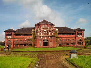
Ratnagiri is a port city on the Arabian Sea coast in Ratnagiri District in the southwestern part of Maharashtra, India. The district is a part of Konkan division of Maharashtra. The city is known for the Hapus or Alphonso mangoes. Ratnagiri is the birthplace of Indian independence activist Lokmanya Tilak. Thibaw, the last king of Burma, alongside his consort Supayalat and two infant daughters were exiled to a two-storied brick mansion in Ratnagiri. The building is now known as Thibaw Palace.
The Maharashtra State Board of Secondary and Higher Secondary Education is a statutory and autonomous body established under the "Maharashtra Secondary Boards Act" 1965. Most important task of the board, among few others, is to conduct the SSC for 10th class and HSC for 12th class examinations. It is the most popular education board in terms of enrollment in high school in India only after the Central Board of Secondary Education.
Kolhapur district is a district in the Maharashtra state of India. The city of Kolhapur is its district headquarter. It is situated near Panchaganga river.
Navapur is a Nagar Parishad (municipality) and headquarters for Navapur Taluka in Nandurbar district, in the state of Maharashtra, India.
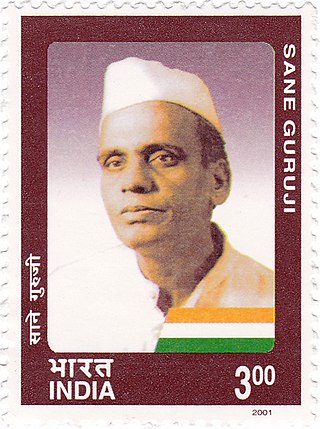
Pandurang Sadashiv Sane ; 24 December 1899 – 11 June 1950), also known as Sane Guruji by his students and followers, was a Marathi author, teacher, social activist and freedom fighter from Maharashtra, India. He is referred to as the National Teacher of India.
Gadhinglaj ([ɡəɖᵊɦiŋɡləd͡z]) is a city in India in the Kolhapur district in the southwest corner of the state of Maharashtra, India. It is located on the banks of the river Hiranyakeshi. It is the Taluka (Tehsil) headquarters of Gadhinglaj Taluka and a subdivision headquarters of the Gadhinglaj Subdivision of the Kolhapur District. It is governed by a municipal council. The rapidly growing city is the third largest in the Kolhapur District, with population of more than 50,000. Places to visit like Samagad fort, temples and beautiful weather.
Ichalkaranji is a city in Kolhapur District, Indian state of Maharashtra, governed by a municipal corporation. It is known for its textile manufacturing industry and "Manchester City of Maharashtra". Ichalkaranji corporation website https://ichalkaranjimnp.in/
Jaysingpur is a city and municipal council in the Kolhapur district of the Indian state of Maharashtra. The city derives its name from Raja Jaysing, the father of Shrimant Chhatrapati Shahu Maharaj of Kolhapur, who planned and developed the architecture of the city. Shahu Maharaj laid out Jaysingpur as one of the few "chess board cities" in Maharashtra where roads meet at 90-degree angles. Jaysingpur has emerged as a satellite of Sangli city and is growing at rapid pace.
The Shikshan Prasarak Mandali, Pune, is one of the private educational societies in Maharashtra. It was established in 1883 with the aim of imparting western education in Marathi language but without any help from the then British government. The Nutan Marathi Vidyalaya (NuMaVi) was established by this society in the same year in the memory of Marathi writer and scholar Vishnushastri Chiplunkar. In 1916 it went on to establish the New Poona College for arts.

The Deccan Education Society is an organisation that runs 43 education establishments in Maharashtra, India. Its main branch is situated in Pune.
Modern education was introduced to Maharashtra region during the 19th century by British colonial administration. Census of 2011 showed literacy rates in the state for males and females were around 78% and 67% respectively. Education at different levels in the state is provided by the state, government supported charities, or private institutions. There are also a number of institutes offering vocational training.

Lokmanya Tilak High School, is an English medium school located in Tilak Nagar, Chembur in Mumbai, India. It began operating in 1967, drawing its students mainly from middle-class families in the area around Tilak Nagar. A semi-government School, it is owned by Tilak Nagar Education Society and managed by the Government of Maharashtra and it is affiliated to Maharashtra SSC Board. The school is named after Bal Gangadhar Tilak (1856–1920).
Soonabai Pestonji Hakimji High School is a school located in Bordi, Maharashtra, India. Established in 1920
Kadgaon is a town situated Gadhinglaj Taluka of Kolhapur district situated in the southwest corner of the state of Maharashtra, India. Kadgaon is about 4 km from Gadhinglaj, 79 km from Kolhapur. Kadgaon is situated on MH SH 134 and is about 15 km from National Highway 48 (NH48). It is managed by Town Council. It is in the phase of transforming from a small town to a bustling city. It is the second-largest city after Gadhinglaj in Gadhinglaj Taluka also second largest city in Gadhinglaj sub division which Include talukas of Gadhinglaj, Ajra, Bhudargad, Chandgad. As of 2012 it has a population of about 20,851. Kadgaon has amenities that are of the level of Municipal Council in India. Kadgaon has developed as an industrial hub in recent years. It has a strong agricultural sector and is known for its sugarcane, jaggery and red chili production. It is well connected to all of Kolhapur and Maharashtra. It has a very excellent civic amenities. Like in most of the case in the Maharashtra the primary Language spoken is Marathi with 20,851 speaking as their primary Language.
Mahagaon is a town in Gadhinglaj Taluka, Kolhapur district, situated in the southwest corner of the state of Maharashtra, India, on the banks of the Hiranyakeshi river. It is about 10 kilometres (6.2 mi) south of Gadhinglaj and 14 kilometres (8.7 mi) from the city of Kadgaon. It is managed by a town council. In 2011, it had a population of about 20,108.
Mungurwadi is a town in Gadhinglaj Taluka of Kolhapur district in Maharashtra, India. In 2001 it had a population of 3,271, but as of 2011, it has a population of 12,199. It is a major market place and the tenth largest settlement in Gadhinglaj taluka. Mungurwadi is about 24 km from Gadhinglaj, 29 km from second-largest settlement Kadgaon and 12 km from National Highway 48 (NH48).
Boisar is the largest industrial suburb in the Mumbai Metropolitan Region in the Indian state of Maharashtra. It was originally a part of the Thane district before becoming a part of the Palghar district. It is approximately 111 kilometers away from the state capital Mumbai, and is 98 km (61 mi) from the union territory Daman. It is located in the district Palghar in Maharashtra.

Huzurpaga is the oldest Indian run girls' high school in India.

