The Queen's Medical Centre is a teaching hospital situated in Nottingham, England. Until February 2012, when it was surpassed by the Royal London Hospital, it was the largest hospital in the United Kingdom, though its remains the largest major trauma centre in England. It is managed by Nottingham University Hospitals NHS Trust.

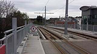
Nottingham Express Transit (NET) is a 32-kilometre-long (20 mi) tram system in Nottingham, England. The system opened to the public on 9 March 2004 and a second phase, that more than doubled the size of the total system, opened on 25 August 2015, having been initially planned to open two years earlier.
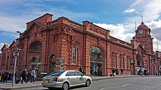
Nottingham station, briefly known as Nottingham City and for rather longer as Nottingham Midland, is a railway station and tram stop in the city of Nottingham. It is the principal railway station of Nottingham. It is also a nodal point on the city's tram system, with a tram stop that was originally called Station Street but is now known as Nottingham Station.
Dunkirk is a residential area of Nottingham, England which is located to the south-east of the University of Nottingham and the Queen's Medical Centre. It is in the electoral ward of 'Dunkirk and Lenton', part of the Nottingham South constituency, with a population of 10,920 in the 2011 census.
Clifton is a large suburban village and historic manor in the city of Nottingham, England. In 2020 it had an estimated population of 22,749.

Bulwell station, previously known as Bulwell Market station, is a railway station and tram stop in Bulwell, Nottingham, England. It is located on the Robin Hood Line and the Hucknall branch of the Nottingham Express Transit (NET).

Nottingham City Transport (NCT) is the major bus operator of the city of Nottingham, England. NCT operates extensively within Nottingham as well beyond the city boundaries into Nottinghamshire county. Publicly-owned, it is today the second largest municipal bus company in the United Kingdom after Lothian Buses in Edinburgh, Scotland.

Nottingham is the seventh largest conurbation in the United Kingdom; despite this, the city's transport system was deemed to be poor for its size in the 1980s. In the early twenty-first century, the UK government invested heavily in the transport network of Nottingham, which has led to the re-opening of the Robin Hood Line and the construction of a light rail system, Nottingham Express Transit.

Phoenix Park is a tram stop on the Nottingham Express Transit (NET) light rail system, in the city of Nottingham suburb of Bulwell. It serves as one of the two northern termini of the NET's initial system, and is at the end of the short single line branch from Highbury Vale. The stop has a single island platform, flanked by two stub tracks which are segregated from the adjacent road. Phoenix Park serves as one of several park and ride stops on the NET network, with more than 600 car parking spaces located next to the stop.

Lace Market is a tram stop of the Nottingham Express Transit (NET) in the centre of the city of Nottingham. It is situated on Fletcher Gate in Nottingham's historic Lace Market quarter, from which it derives its name, and near to the Hockley quarter.

University of Nottingham is a tram stop on the Nottingham Express Transit (NET) network in the English city of Nottingham and adjacent to the University Park Campus of the University of Nottingham. It is situated on reserved track between University Boulevard (A6005) and the campus, and comprises a pair of side platforms flanking the tracks. The stop is on line 1 of the NET, from Hucknall via the city centre to Beeston and Chilwell. Trams run at frequencies that vary between 4 and 8 trams per hour, depending on the day and time of day.
Basford is a tram station on Nottingham Express Transit (NET), in the city of Nottingham suburb of Basford. The tram lines here run parallel to the Robin Hood railway line that links Nottingham with Worksop, but there is no corresponding railway station. Both tram and railway lines have two tracks, and the resulting four tracks are crossed by a pedestrian bridge. The tram stop comprises a pair of side platforms on both sides of the tramway.
Cinderhill is a tram stop on the Nottingham Express Transit (NET) light rail system in the city of Nottingham on the boundary between the suburbs of Basford and Bulwell. It was part of the NET's initial system, and is situated in the middle of the short single line branch between Highbury Vale and Phoenix Park tram stops. The stop comprises a single platform and track, situated in a cutting between two bridges and served by trams running in both directions.

Wilkinson Street is a tram stop on Nottingham Express Transit (NET), in the city of Nottingham suburb of Basford. The tram stop opened on 9 March 2004, along with NET's initial system. It is one of several park and ride stops on the NET network, with more than 600 car parking spaces located next to the stop. NET's Wilkinson Street depot is also adjacent to the stop, and provides storage and maintenance facilities for all the system's trams, having been expanded to cope with the additional trams ordered for phase two. The depot also contains NET's offices, staff facilities and control room.
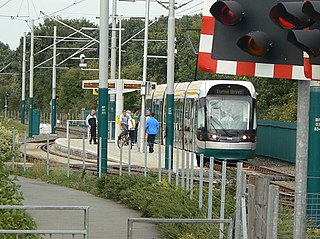
Bulwell Forest is a tram stop on the Nottingham Express Transit (NET) light rail system in the city of Nottingham in the suburb of Bulwell. It is part of the NET's initial system, and is situated on the long single line section between Bulwell and Hucknall tram stops that runs alongside the Robin Hood railway line. Like all the other intermediate stops on this section, the stop has a passing loop with an island platform situated between the two tracks of the loop.

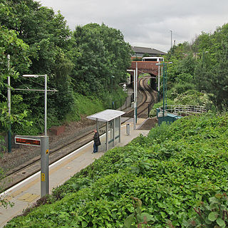
Moor Bridge is a tram stop on the Nottingham Express Transit (NET) light rail system in the city of Nottingham in the suburb of Bulwell. It is part of the NET's initial system, and is situated on the long single line section between Bulwell and Hucknall tram stops that runs alongside the Robin Hood railway line. Like all the other intermediate stops on this section, the stop has a passing loop with an island platform situated between the two tracks of the loop.

University Boulevard is a tram stop on the Nottingham Express Transit (NET) network in the city of Nottingham. It is situated on reserved track alongside University Boulevard (A6005) close to the boulevard's junction with Queen's Road East and Lower Road, and comprises a pair of side platforms flanking the tracks. The stop is on line 1 of the NET, from Hucknall via the city centre to Beeston and Chilwell. Trams run at frequencies that vary between 4 and 8 trams per hour, depending on the day and time of day.

Toton Lane is a tram stop and park and ride site on the Nottingham Express Transit network, serving the suburb of Chilwell and town of Stapleford, Broxtowe in Nottinghamshire, England.
High Road – Central College is a tram stop on the Nottingham Express Transit (NET) network, in the district of Broxtowe, East Midlands, United Kingdom. The stop lies immediately to the Beeston side of the boundary between the suburbs of Chilwell and Beeston. The original proposed name for the stop was Castle College, and some publications still use that name.