
Nakodar is a town and a municipal council in Jalandhar district in the Indian state of Punjab.
Khaira is a village in Ludhiana district in the Indian state of Punjab.
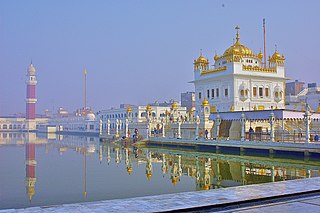
Tarn Taran Sahib is a city in the Majha region of the state of Punjab, in northern India. It is the district headquarters and hosts the municipal council of Tarn Taran district. Gurdwara Sri Tarn Taran Sahib, a prominent Sikh shrine, is located in the central part of the city.
Sadulpur ,(previously known as Rajgarh) is a city, municipality, tehsil and Legislative Assembly seat in Churu district of northern part of Rajasthan state in India. It lies in Shekhawati region at an elevation of 239 m (784 ft). To distinguish Rajgarh from several other places with same name, Sadulpur has become a synonym of Rajgarh town's name in recent times.
Phillaur is a town and a municipal council as well as a tehsil in Jalandhar district in the Indian state of Punjab. The city is situated 20 km from Ludhiana, 45 km from Jalandhar and 140 km from Amritsar. It is situated on the border of the Doaba and Puadh regions. Thr city was Founded by a Hindu Jat, Chaudhary Phul Rai Sanghera, during the 12-13th century as Phulnagar, but later came to be known as Phillaur.

Faridkot district is a district lying in the South-Western part of Punjab, India with Faridkot city as the district headquarters.

Ludhiana district is one of the 23 districts in the Indian state of Punjab. It is Punjab's largest district by both area and population. Ludhiana, the largest city in Punjab, is the district headquarters.
The town of Mullanpur Dakha,' also known as Mandi Mullanpur, is located in the Ludhiana district in the Indian state of Punjab. It is a nagar panchayat, a settlement in transition from rural to urban. Due to the availability of transport routes to other villages, the town serves as a marketplace of grain and other goods to the surrounding area.
Halwara is a township in Punjab state in India. Located in the Ludhiana close to Village Sudhar, Halwara lies on the Mullanpur-Raikot road. It is also famous for its Air Base. it is 33 km from Ludhiana 15 km from Mullanpur 6 km from Sadhar.In this town the bypass of Ludhiana also joins Mullanpur-Raikot road. Halwara also boasts the largest military airbase in northern India.
Rajoana Kalan and Rajoana Khurd are villages in the Ludhiana district, Punjab, India.
Dhudike is a village in Moga Tehsil in Moga district of Punjab state, India. It is located 17 km east from city of Moga, the district headquarter. Freedom fighters like Baba Ishar Singh, Baba Pala Singh Jathedar, Baba Pakhar Singh are a few of the Gadaree from Dhudike who participated in the Gadar Movement during the struggle for independence. Dhudike is the birthplace of the famous revolutionary Lala Lajpat Rai.
Lakhpur is a village near Sahni (Lakhpur-Sahni), Tehsil Phagwara, Kapurthala district, in Punjab, India.
Jagpalpur is a village in Tehsil Phagwara, Kapurthala district, in Punjab, India.
Chakar is a village in the Jagraon tehsil of Ludhiana district in Indian Punjab. It is located on the Guru Gobind Singh Marg. The sixth Sikh guru, Guru Hargobind Sahib visited this place in 1631 during his tour of Malwa region and the tenth master, Guru Gobind Singh in 1705 after the battle of Chamkaur Sahib
Rurka Khurd is a large size village in Phillaur tehsil of Jalandhar District of Punjab State, India. Kalan is Persian language word which means Big and Khurd is Persian word which means small when two villages have same name then it is distinguished with Kalan means Big and Khurd means Small used with Village Name. It is located 1.6 km away from postal head office Goraya, 16.7 km from Phillaur, 35 km from district headquarter Jalandhar and 129 km from state capital Chandigarh. The village is administrated by a sarpanch who is an elected representative of village as per Panchayati raj (India). The man in the photograph is native to this village. It was his first time getting his picture taken as well. He is a cattle herder. His name is Jattmandeep Singh and has a rich knowledge of the village
Sri Bhaini Sahib is a village located in the Ludhiana East tehsil, of Ludhiana district, Punjab. It was previously known as Bhaini Bhoondar and Bhaini Ala. Earlier, it was also referred to as Bhaini Kookean and Ramdaspura. Sri Bhaini Sahib is an important historic place of Punjab, being the focal point of Namdhari sect, founded by Sat Guru Ram Singh.

