
Gorkha District, a part of Gandaki Pradesh, is one of the seventy-Seven districts of Nepal and connected historically with the creation of the modern Nepal and the name of the legendary Gurkha soldiers. The district, with Gorkha Municipality as its district headquarters, covers an area of 3,610 km2 (1,390 sq mi) and has a population (2001) of 288,134. It is the location of the Manakamana Temple. Also, the temples of great sage Gorakh Nath and goddess Gorakh Kali temple is located in district, after which the district got its name. Four major rivers run within and along it - the Chepe, Daraudi, Marsyangdi, and Budhi Gandaki.

Lamjung District, a part of Gandaki Pradesh, is one of the 77 districts of Nepal. The district, with Besisahar as its district headquarters, covers an area of 1,692 square kilometres (653 sq mi) and as of 2011 had a population of 167,724. Lamjung lies in the mid-hills of Nepal spanning tropical to trans-Himalayan geo-ecological belts, including the geographical midpoint of the country. It has mixed habitation of casts and ethnicities. It is host to probably the highest density of the Gurung ethnic population in the country.

Tanahun District, a part of Gandaki Pradesh, is one of the seventy-seven districts of Nepal. The district, with Damauli as its district headquarters, covers an area of 1,546 km2 (597 sq mi) and has a population (2011) of 323,288. Previously the town of Bandipur was its district headquarter. This district lies in the middlemost of country Nepal. The postal code of Tanahun is 33900.

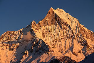
Besishahar is a municipality and the district headquarters of Lamjung District in Gandaki Pradesh, Nepal. The Besishahar Municipality was formed by merging the existing Village Development Committees i.e. Besishahar, Gaunshahar, Udipur, Chandisthan, Baglungpani, Bajhakhet, Hiletaksar and Chiti and have 11 wards. Here are different castes and religions. So they have different culture. This municipality has a sub-tropical climate with deciduous forests. Annapurna II, Machhapuchhre, Lamjung Himal can be viewed from north of Besishahar Municipality.
Bhujel, also called Bujhyal, is a Chepangic language spoken in central Nepal. It is a semi-tonal language, employing a complex array of affixes.

Takukot is a Ward of Barpak sulikot Rural Municipality in Gorkha District in the Gandaki Province of northern-central Nepal. At the time of the 1991 Nepal census it had a population of 4,234 and had 801 houses in the town.

Vyas (Byas), is a municipality of Tanahun District located in Gandaki Pradesh in Nepal and incorporates the village Damauli, the district's headquarter, for which the municipality is also often referred to as Damauli. The municipality was established by merging the former Village development committee Damauli with several of its neighbors, the most recent merger being the one with Pokhari Bhanjyang in 2014. It lies on the bank of Madi Khola.

Tinpiple is situated near the Chepe River. The Chepe River is the borderline between the Gorkha and Lamjung districts and originates in Dudhpokhari. The river has a long historical background and is seen as a sign of love and affection as well as the barrier to brotherhood.

Bhanu is a municipality of Tanahun District in Gandaki Zone of western Nepal. The municipality was established on 19 September 2015 by merging the existing Bhanu village development committee or VDC, Barbhanjyang VDCs, Rupakot (VDC), Tanahunsur Village Development Committee, Purkot VDC, Mirlung VDC, Satiswara VDC, Risti VDC, Basantapur VDC and Chok Chisapani VDC. The center of the municipality is establish in former VDC Office of Bhanu. After merging the population of all of the VDCs, it had a total population of 46,179 according to 2011 Nepal census. After the government decision the number of municipalities has reached 217 in Nepal. Nepali poet Bhanubhakta Acharya was born in Bhanu Municipality. It was name after him.
Majibari is a small village in Dudhpokhari VDC, in the east Lamjung.
Gandaki Pradesh is one of the seven federal provinces established by the current constitution of Nepal which was promulgated on 20 September 2015. Pokhara is the province's capital city. It borders the Tibet Autonomous Region of China to the north, Bagmati Pradesh to the east, Karnali Pradesh to the west, and Province No. 5 and Uttar Pradesh of India to the south. The total area of the province is 21,504 km². According to the latest census, the population of the province was 2,403,757. The newly elected Provincial Assembly adopted Gandaki Pradesh as the permanent name by replacing its initial name Province no. 4 in July 2018.
Dordi Rural Municipality is one of the local level rural municipalities of Lamjung District, of its 8 local municipalities.
Dudhpokhari Rural Municipality is one of the local level of Lamjung District out of 8 local levels. It has 6 wards and according to census 2011, 10,975 people live in here. It has 153.33 square km area. Its center is in the office of previous Gauda V.D.C. Gorkha District is in the east, Dordi Rural Municipality is in the west, Dordi Rural Municipality is in the north and Rainas Municipality and Gorkha District are in the south of Dudhpokhari Rural Municipality. Previous Dudhpokhari V.D.C., previous Bichaur V.D.C., previous Ilampokhari V.D.C., previous Kolki V.D.C. and previous Gauda V.D.C are included in this newly made municipality.
Madhya Nepal Municipality is one of the local level of Lamjung District out of 8 local levels. It has 10 wards and according to 2011 Nepal census, 23,385 people live in here. It has 113.86 square km area. Its center is in the office of previous Karaputar Municipality. Sundarbazar Municipality is in the east, Kaski district is in the west, Kwhlosothar Rural Municipality and Besisahar Municipality are in the north and Tanahun District is in the south of Madhya Nepal Municipality. Previous Madhya Nepal Municipality, previous Karaputar Municipality and previous Neta V.D.C. are included in this newly made municipality.
Marsyandi Rural Municipality is one of eight municipalities in Lamjung District, Nepal. It has 9 wards and, according to the 2011 census, a population of 18,759 people. The municipality is 597.25 km2 (230.60 sq mi) in area, and its administrative center is in the office of the previous Bhulbhule V.D.C. Gorkha District and Dordi Rural Municipality are to the east, Kwhlosothar Rural Municipality and Kaski District are to the west, Manang District, Kaski District and Gorkha District are in the north, and Besisahar Municipality, Dordi Rural Municipality and Kwhlosothar Rural Municipality are to the south of Marsyandi Rural Municipality. Previous portions of Ghanpokhara V.D.C., Khudi V.D.C., Taghring V.D.C., Ghermu V.D.C., Bahundanda V.D.C, Bhulbhule V.D.C and Simpani V.D.C.(all wards) are included in this newly-made rural municipality.
Sundarbazar Municipality is one of eight municipalities in Lamjung District, Nepal. It has 11 wards and, according to the 2011 census, a population of 26,861. Sundarbazar Municipality is 72.05 km2 (27.82 sq mi) in area, and its administrative center is in the office of the previous Sundarbazar Municipality. Dordi Rural Municipality and Rainas Municipality are to the east, Madhya Nepal Municipality is to the west, Besisahar Municipality is to the north and Rainas Municipality and Tanahun District are to the south of Sundarbazar Municipality. The newly-redrawn version of Sundarbazar Municipality includes the old versions of Chandreshwor V.D.C., Duradanda V.D.C., Dhuseni V.D.C. and Sindure V.D.C.
Gangajamuna is a Gaupalika(Nepali: गाउपालिका ; gaupalika) Formerly: village development committee) in Dhading District in the Bagmati Zone of central Nepal. The local body was formed by merging five VDCs namely Rigaun, Gumdi Phulkharka, Baseri and Budhathum. Currently, it has a total of 7 wards. The population of the rural municipality is 21,784 according to the data collected on 2017 Nepalese local elections.
Gangajamuna is a Gaupalika(Nepali: गाउपालिका ; gaupalika) Formerly: village development committee) in Dhading District in the Bagmati Zone of central Nepal. The local body was formed by merging four VDCs namely Khari, Dhola, Nepal, Maidi and Chainpur, Bagmati. Currently, it has a total of 7 wards. The population of the rural municipality is 23,966 according to the data collected on 2017 Nepalese local elections.
