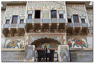
Churu is a city in the desert region of Rajasthan state of India. It is known as the gateway to the Thar Desert of Rajasthan. It is the administrative headquarter of Churu District. It lies in the Thar Desert on the National Highway 52 connecting Sangrur to Ankola and is a junction station on the railway line to Bikaner. It is near the shifting sand dunes of the Thar Desert and has grand havelis with marvelous fresco paintings, namely Kanhaiya Lal Bagla Ki Haweli and Surana Haweli, with hundreds of small windows. It also has some fine Chhatris. Near the town is a religious seat of the Nath sect of Sadhus where there are life-size marble statues of their deities and a place for prayers. At the center of the town is a fort built about 500 years ago.
Sikar is a city located midway between Agra and Churu on the National Highway 52 in the state of Rajasthan in India. It is a part of the Shekhawati region.
Also see Ratannagar, Churu
Nawalgarh is a heritage city in Jhunjhunu district of Indian state Rajasthan. It is part of the Shekhawati region and is midway between Jhunjhunu and Sikar. It is 30 km from Sikar and 39 km from Jhunjhunu. Nawalgarh is famous for its fresco and havelis and considered as Golden City of Rajasthan. It is also the motherland of some great business families of India.
Sujangarh is a city in the Churu district in the Shekhawati region of Rajasthan, India. Sujangarh lies on the Ambala-Pali Highway and Hanumangarh-Kishangarh Mega Highway. The town is well known for a second Tirupati Balaji Temple.The first one being in Tirumala - the Tirupati Balaji Venkateshwar Mandir. It is the first of its kind built in South Indian style, in Rajasthan. Lord Shiva Temple on Sujangarh Road in Thardaa and Dungar Balaji on Sujangarh - Dungar Balaji Road in Gopalpura are other two nearby Hindu temples that are popular. Sri Devsagar Singhi Jain Mandir at Sujangarh is a century old Jain Tirth that is located within the town.
Rajgarh, in bagar tract along Haryana-Rajasthan border, is a city, municipality, tehsil and Legislative Assembly seat in Churu district of northern part of Rajasthan state in India. It lies in Shekhawati region at an elevation of 239 metres (784 ft). To distinguish Rajgarh from several other places with same name, Sadulpur has become a synonym of Rajgarh town's name in recent times.
Mandawa is a town in Jhunjhunu district of Rajasthan in India. It is part of Shekhawati region. Mandawa is located at 28.05°N 75.15°E. It has an average elevation of 316 metres (1036 ft).

Churu district is a district of the Indian state of Rajasthan in northern India. It was founded by Banirot Rajputs. Some believe it was a village of jats known as kalera ka bas. Thakur Kushal Singh constructed the Churu fort in 1649 and during the battle of 1871 the area came under dominance of Bikaner. The town of Churu is the administrative headquarters of the district.
Sikar district is a district of the Indian state Rajasthan in northern India. The city Sikar is the administrative headquarters of the district. Sikar, Laxmangarh, Sri Madhopur, Neem Ka Thana, and Fatehpur Shekahwati are the largest cities and tehsils of the district.
NK Bhadra is a city and a municipality in Hanumangarh district in the state of Rajasthan, India.
Chhapar is a small town and a municipality in Churu district in the state of Rajasthan, India. Chhapar and Tal chhapar is located in the Churu district of Northwestern Rajasthan in the Shekhawati region of India. It is 210 km from Jaipur and situated on the road from Ratangarh to Sujangarh. The Tal Chappar lies in the Sujangarh Tehsil of Churu district. It lies on the Nokha-Sujangarh state highway and is situated at a distance of 85 km from Churu and about 132 km from Bikaner. The nearest railway station is Chappar which lies on Degana-Churu-Rewari broad gauge line of Northern Western Railways. The nearest Airport is Jaipur International Airport (Sanganer) which is at a distance of 215 km from Chappar. It is known for black bucks but it is also home to a variety of birds. Here is a famous sanctuary known as Tal Chhapar Sanctuary
Khandela is a town and municipality in the Sikar district of the Indian state of Rajasthan.
Mangrol is a town with municipality and tehsil in Baran district in the Indian state of Rajasthan. Pincode of Mangrol is 325215. It is the nearby location of famous Ramgarh crater made from the meteorite strike, also famous for the 11th century rock temple Bhand Deva Temple.It is also famous for ढाई कड़ी की रामलीला.
Neem Ka Thana is a small town in Sikar district in the Rajasthan state of India.
Rajaldesar is a City and a Municipality in Churu District in the Indian State of Rajasthan. Rajaldesar is well connected through Indian Railways.
Also See Ratangarh, Churu
Sri Madhopur or Shrimadhopur is a city and a municipality in Sikar district in the Indian state of Rajasthan. It was founded on 18 April 1990 by the King Sawai Man Singh. It was mainly famous for his temples. Shrimadhopur Wheat market is the biggest wheat market in Sikar district. Shrimadhopur Government school is one of the biggest school of the sikar district. It is one of the six tehsils of the district. Dedicated Delhi-Mumbai Freight Corridor is passing through this city. This city is chosen for the development of crossing station on this route.
Udaipurwati is a small town in Shekhawati and a municipality in Jhunjhunun district in the Indian state of Rajasthan. Sikar, Sri Madhopur and Neem ka thana are some more developed towns near Udaipurwati. Udaipurwati (उदयपुरवाटी) is a town and tahsil in the Jhunjhunu district in Rajasthan. Its ancient name, mentioned in Harsha Inscription 961 AD (L-39), was Udarbhatika (उदर्भटिका).Udaipurwati is the land of Shekhawati Gandhi Shahid Karni Ram and Ramdev. There are many temples that commemorate them like Mansa Mata Mandir, Kalika Mata Mandir Majhau, Jamway Mata Bhorki, Shati Dadi Mandir Ked and Shakambhari Mata.
Nangal is a village located in the Sikar district of the Indian state Rajasthan. It is 11 km away from Palsana, 10 km from Khandela, 3 km from Bamanwas and 3.5 km away from Dudhwalo ka Bass.
Sujawas is a village in Piprali tehsil, Sikar district, Rajasthan state, India. It belongs to Jaipur Division. It is located 18 kilometres (11 mi) east from its district headquarters at Sikar and 102 kilometres (63 mi) from the state capital at Jaipur.

