Rawlins Township, Illinois

Last updated • 1 min readFrom Wikipedia, The Free Encyclopedia

Rawlins Township
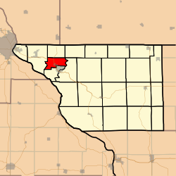
Map highlighting Rawlins Township, Jo Daviess County, Illinois.svg
Location in Jo Daviess County
Map of Illinois highlighting Jo Daviess County.svg
Jo Daviess County's location in Illinois
Coordinates: 42°26′45″N90°26′32″W / 42.44583°N 90.44222°W / 42.44583; -90.44222
Country United States
State Illinois
County Jo Daviess
EstablishedJuly 12, 1887
Government
  SupervisorDorothy Petitgout
Area
  Total11.73 sq mi (30.4 km2)
  Land11.73 sq mi (30.4 km2)
  Water0 sq mi (0 km2)  0%
Elevation
850 ft (259 m)
Population
 (2010)
  Estimate 
(2016) [1]
444
  Density38.8/sq mi (15.0/km2)
Time zone UTC-6 (CST)
  Summer (DST) UTC-5 (CDT)
ZIP codes
61025, 61036
FIPS code 17-085-62926

Rawlins Township is one of 23 townships in Jo Daviess County, Illinois, United States. As of the 2010 census, its population was 455 and it contained 189 housing units. [2] It was formed as Grant Township from West Galena Township on July 12, 1887; its name changed to Rawlins Township on December 20, 1887 in honor of Galena resident John Aaron Rawlins.

Contents

Geography

According to the 2010 census, the township has a total area of 11.73 square miles (30.4 km2), all land. [2]

Cities, towns, villages

Major highways

Demographics

Historical population
CensusPop.Note
2016 (est.)444 [1]
U.S. Decennial Census [3]

School districts

Political districts

Related Research Articles

<span class="mw-page-title-main">Jo Daviess County, Illinois</span> County in Illinois, United States

Jo Daviess County is the northwesternmost county in the U.S. state of Illinois. According to the 2020 census, it had a population of 22,035. Its county seat is Galena. Jo Daviess County is part of the Tri-State Area and is located near Dubuque, Iowa and Platteville, Wisconsin. As part of the Driftless Area, Jo Daviess County contains rugged terrain compared to the rest of the state. Within Jo Daviess County lies Charles Mound, the highest natural point in Illinois, as well as eight of the ten highest points in Illinois.

<span class="mw-page-title-main">Warren Township, Jo Daviess County, Illinois</span> Township in Illinois, United States

Warren Township is one of twenty-three townships in Jo Daviess County, Illinois, United States. As of the 2010 census, its population was 1,601, and it contained 770 housing units. Its name changed from Courtland Township in 1865.

<span class="mw-page-title-main">Apple River Township, Illinois</span> Township in Illinois, United States

Apple River Township is one of 23 townships in Jo Daviess County, Illinois, United States. As of the 2010 census, its population was 498 and it contained 257 housing units. It was formed from Thompson Township on September 13, 1858.

<span class="mw-page-title-main">Berreman Township, Illinois</span> Township in Illinois, United States

Berreman Township is one of 23 townships in Jo Daviess County, Illinois, United States. As of the 2010 census, its population was 147 and it contained 73 housing units. It was formed from Pleasant Valley Township on February 14, 1857.

<span class="mw-page-title-main">Council Hill Township, Illinois</span> Township in Illinois, United States

Council Hill Township is one of 23 townships in Jo Daviess County, Illinois, United States. As of the 2010 census, its population was 141 and it contained 82 housing units. Its name changed from Scales Township on December 6, 1853.

<span class="mw-page-title-main">Dunleith Township, Illinois</span> Township in Illinois, United States

Dunleith Township is one of 23 townships in Jo Daviess County, Illinois, United States. As of the 2010 census, its population was 3,820 and it contained 1,713 housing units. It was formed from Menominee Township on March 2, 1865.

<span class="mw-page-title-main">East Galena Township, Illinois</span> Township in Illinois, United States

East Galena Township is one of twenty-three townships in Jo Daviess County, Illinois, United States. As of the 2010 census, its population was 1,283 and it contained 917 housing units.

<span class="mw-page-title-main">Elizabeth Township, Illinois</span> Township in Illinois, United States

Elizabeth Township is one of 23 townships in Jo Daviess County, Illinois, United States. As of the 2010 census, its population was 1,111 and it contained 579 housing units.

<span class="mw-page-title-main">Hanover Township, Jo Daviess County, Illinois</span> Township in Illinois, United States

Hanover Township is one of 23 townships in Jo Daviess County, Illinois, United States. As of the 2010 census, its population was 1,201 and it contained 689 housing units.

<span class="mw-page-title-main">Menominee Township, Illinois</span> Township in Illinois, United States

Menominee Township is one of 23 townships in Jo Daviess County, Illinois, United States. As of the 2010 census, its population was 1,122 and it contained 419 housing units.

<span class="mw-page-title-main">Nora Township, Illinois</span> Township in Illinois, United States

Nora Township is one of 23 townships in Jo Daviess County, Illinois, United States. As of the 2010 census, its population was 370 and it contained 168 housing units.

<span class="mw-page-title-main">Pleasant Valley Township, Illinois</span> Township in Illinois, United States

Pleasant Valley Township is one of 23 townships in Jo Daviess County, Illinois, United States. As of the 2010 census, its population was 273 and it contained 157 housing units.

<span class="mw-page-title-main">Rice Township, Illinois</span> Township in Illinois, United States

Rice Township is one of 23 townships in Jo Daviess County, Illinois, United States. As of the 2010 census, its population was 338 and it contained 268 housing units. It was formed as Washington Township from East Galena Township on February 22, 1859; its name changed to Rice Township on June 16, 1859.

<span class="mw-page-title-main">Scales Mound Township, Illinois</span> Township in Illinois, United States

Scales Mound Township is one of 23 townships in Jo Daviess County, Illinois, United States. As of the 2010 census, its population was 622 and it contained 286 housing units. It was formed from Council Hill and Thompson townships on March 7, 1855.

<span class="mw-page-title-main">Stockton Township, Illinois</span> Township in Illinois, United States

Stockton Township is one of 23 townships in Jo Daviess County, Illinois, United States. As of the 2010 census, its population was 2,453 and it contained 1,141 housing units.

<span class="mw-page-title-main">Vinegar Hill Township, Jo Daviess County, Illinois</span> Township in Illinois, United States

Vinegar Hill Township is one of 23 townships in Jo Daviess County, Illinois, United States. As of the 2010 census, its population was 364 and it contained 143 housing units. Its name changed from Mann Township on September 18, 1857.

<span class="mw-page-title-main">Wards Grove Township, Jo Daviess County, Illinois</span> Township in Illinois, United States

Wards Grove Township is one of 23 townships in Jo Daviess County, Illinois, United States. As of the 2010 census, its population was 224 and it contained 103 housing units.

<span class="mw-page-title-main">West Galena Township, Jo Daviess County, Illinois</span> Township in Illinois, United States

West Galena Township is one of 23 townships in Jo Daviess County, Illinois, United States. As of the 2010 census, its population was 3,323 and it contained 1,849 housing units.

<span class="mw-page-title-main">Woodbine Township, Jo Daviess County, Illinois</span> Township in Illinois, United States

Woodbine Township is one of 23 townships in Jo Daviess County, Illinois, United States. As of the 2010 census, its population was 584 and it contained 399 housing units. Its name changed from Jefferson Township on September 13, 1853.

<span class="mw-page-title-main">Guilford Township, Illinois</span> Township in Illinois, United States

Guilford Township is one of 23 townships in Jo Daviess County, Illinois, United States. At the 2010 census, its population was 1,206 and it contained 1,972 housing units.

References

  1. 1 2 "Population and Housing Unit Estimates" . Retrieved June 9, 2017.
  2. 1 2 "Population, Housing Units, Area, and Density: 2010 - County -- County Subdivision and Place -- 2010 Census Summary File 1". United States Census. Archived from the original on February 12, 2020. Retrieved May 28, 2013.
  3. "Census of Population and Housing". Census.gov. Retrieved June 4, 2016.