Southern California is a geographic and cultural region that generally comprises the southern portion of the U.S. state of California. It includes the Los Angeles metropolitan area, the second most populous urban agglomeration in the United States. The region generally contains ten of California's 58 counties: Imperial, Kern, Los Angeles, Orange, Riverside, San Bernardino, San Diego, Santa Barbara, San Luis Obispo and Ventura counties. The Colorado Desert and the Colorado River are located on southern California's eastern border with Arizona, and San Bernardino County shares a border with Nevada to the northeast. Southern California's southern border with Baja California is part of the Mexico–United States border.
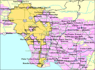
Greater Los Angeles, also called the Southland, with a 2019 population of 18,710,563, is the second-largest urban region area in the United States, encompassing five counties in southern California extending from Ventura County in the west to San Bernardino County and Riverside County on the east, with Los Angeles County in the center and Orange County to the southeast. According to the U.S. Census Bureau, the Los Angeles–Anaheim–Riverside combined statistical area covers 33,954 square miles (87,940 km2), making it the largest metropolitan region in the United States by land area. However, more than half of this area lies in the sparsely populated eastern areas of Riverside and San Bernardino counties. In addition to being the nexus of the world's largest entertainment industry, Greater Los Angeles is also a global center of business, international trade, education, media, fashion, tourism, science and technology, sports, and transportation. It is the 3rd largest metropolitan area by nominal GDP in the world with an economy exceeding $1 trillion in output.

North County is a region in the northern area of San Diego County, California. It is the second-most populous region in the county, with an estimated population of 869,322. North County is well known for its affluence, especially in Encinitas, Carlsbad, Del Mar, Rancho Santa Fe, and Solana Beach, where house prices range, on average, above $1,000,000. Cities along the 78 freeway have more mixed incomes. Places such as south Oceanside, far north Oceanside, east Vista, south Vista, north San Marcos, the San Elijo Hills region of San Marcos, and far west Escondido are typically affluent as well. Homes prices throughout the region range from around $550,000 to $25,000,000.

The Santa Ana Mountains are a short peninsular mountain range along the coast of Southern California in the United States. They extend for approximately 61 miles (98 km) southeast of the Los Angeles Basin largely along the border between Orange and Riverside counties.
The Santa Margarita River which with the addition of what is now Temecula Creek, was formerly known as the Temecula River, is a short intermittent river on the Pacific coast of southern California in the United States, approximately 30.9 miles (49.7 km) long. One of the last free-flowing rivers in southern California, it drains an arid region at the southern end of the Santa Ana Mountains, in the Peninsular Ranges between Los Angeles and San Diego.

The Southern California freeways are a vast network of interconnected freeways in the megaregion of Southern California, serving a population of 23 million people. The Master Plan of Metropolitan Los Angeles Freeways was adopted by the Regional Planning Commission in 1947 and construction began in the early 1950s. The plan hit opposition and funding limitations in the 1970s, and by 2004, only some 61% of the original planned network had been completed.
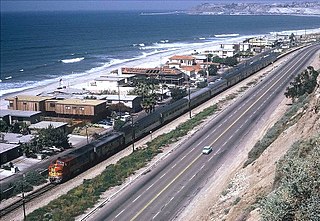
The Surf Line is a railroad line that runs from San Diego north to Orange County along California's Pacific Coast. It was so named because much of the line is near the Pacific Ocean, within less than 100 ft (30 m) in some places. The tracks are now owned by the Southern California Regional Rail Authority and the North County Transit District, and hosts Metrolink's Orange County Line and Inland Empire–Orange County Line, the San Diego Coaster, and Amtrak Pacific Surfliner passenger trains. The BNSF Railway operates freight over the line using trackage rights.
The Southern California Rugby Football Union (SCRFU), is the Geographical Union (GU) governing body within USA Rugby that governs adult rugby union teams in Southern California, the Las Vegas metropolitan area, Arizona, and New Mexico. The SCRFU includes numerous men's and women's, leagues representing all levels of competitive play. College rugby is run by the College conferences and Youth Rugby is governed by Southern California Youth Rugby (SCYR). During the busiest part of the 15s seasons, southern California will have over 80 matches in a weekend. The current board of SCRFU is Geno Mazza (president), Patrick Rashidian, Kevin Holmquist (treasurer) and Bradley Davidson (secretary).

California's State Assembly districts are numbered 1st through 80th, generally in north-to-south order.

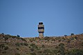
Santiago Peak is the southern mountain of Orange County's Saddleback formation. It is the highest and most prominent peak of both the Santa Ana Mountains and Orange County, and also marks a border point with Riverside County. The top of it is covered with many microwave and telecommunication antennas. It is named for Santiago Creek, which begins on its southwestern flank. During winter, snow does fall on the peak.

Greater Los Angeles has a complex multimodal transportation infrastructure, which serves as a regional, national and international hub for passenger and freight traffic. The transportation system of Greater Los Angeles includes the United States' largest port complex, seven commuter rail lines, Amtrak service, a subway system within the city of Los Angeles, and numerous highways. Los Angeles is integrated into the Interstate Highway System by Interstate 5, Interstate 10, and Interstate 15, along with numerous auxiliary highways and state routes. Bus service is also included locally within the area by numerous local government agencies. Subways and light commuter rail lines are present within Los Angeles proper, allowing mass transportation within the city. Commuter railroads are run by Metrolink. Amtrak has numerous railroad lines that connect Los Angeles to the rest of the country.

Los Angeles Air Route Traffic Control Center is an air traffic control center located in Palmdale, California, United States. It is located at the northeast corner of 25th Street East and Avenue P adjacent to USAF Plant 42 and the LA/Palmdale Regional Airport.

San Mateo Creek is a stream in Southern California in the United States, whose watershed mostly straddles the border of Orange and San Diego Counties. It is about 22 miles (35 km) long, flowing in a generally southwesterly direction. Draining a broad valley bounded by the Santa Ana Mountains and Santa Margarita Mountains, San Mateo Creek is notable for being one of the last unchannelized streams in Southern California.

De Luz is an unincorporated community in Riverside and San Diego Counties, California. De Luz is 6 miles (9.7 km) northwest of Fallbrook and due west of Temecula. The region is approximately 12 miles (19 km) east of the Pacific Ocean and lies at the southern end of the Santa Ana Mountains.
De Luz Heights is an unincorporated community that is in northwestern San Diego County, California, United States.
There are 34 routes assigned to the "S" zone of the California Route Marker Program, which designates county routes in California. The "S" zone includes county highways in Imperial, Orange, Riverside, San Diego, and Santa Barbara counties.
The Perris Block is the central block of three major fault-bounded blocks of the northern part of the Peninsular Ranges. The Perris Block lies between the Santa Ana Block to the west and the San Jacinto Block to the east. The Perris Block, was named by Walter A. English in 1925 for the city of Perris, located near the center of the block.