Reevesville, Illinois

Last updated
Reevesville, Illinois
Unincorporated community
USA Illinois location map.svg
Red pog.svg
Reevesville
Usa edcp location map.svg
Red pog.svg
Reevesville
Coordinates: 37°20′35″N88°43′11″W / 37.34306°N 88.71972°W / 37.34306; -88.71972 Coordinates: 37°20′35″N88°43′11″W / 37.34306°N 88.71972°W / 37.34306; -88.71972
Country United States
State Illinois
County Johnson
Elevation 351 ft (107 m)
Time zone Central (CST) (UTC-6)
  Summer (DST) CDT (UTC-5)
Area code(s) 618
GNIS feature ID 416506 [1]

Reevesville is an unincorporated community in Johnson County, Illinois, United States. The community is located along County Route 10 and the Canadian National Railroad (formerly the Illinois Central) 11 miles (18 km) east-southeast of Vienna. [2]
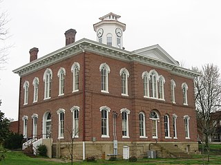
Johnson County, Illinois County in the United States

Johnson County is a county located in the U.S. state of Illinois. According to the 2010 census, it has a population of 12,582. Its county seat is Vienna. It is located in the southern portion of Illinois known locally as "Little Egypt".

Illinois State of the United States of America

Illinois is a state in the Midwestern and Great Lakes region of the United States. It has the fifth largest gross domestic product (GDP), the sixth largest population, and the 25th largest land area of all U.S. states. Illinois is often noted as a microcosm of the entire United States. With Chicago in northeastern Illinois, small industrial cities and immense agricultural productivity in the north and center of the state, and natural resources such as coal, timber, and petroleum in the south, Illinois has a diverse economic base, and is a major transportation hub. Chicagoland, Chicago's metropolitan area, encompasses over 65% of the state's population. The Port of Chicago connects the state to international ports via two main routes: from the Great Lakes, via the Saint Lawrence Seaway, to the Atlantic Ocean and from the Great Lakes to the Mississippi River, via the Illinois Waterway to the Illinois River. The Mississippi River, the Ohio River, and the Wabash River form parts of the boundaries of Illinois. For decades, Chicago's O'Hare International Airport has been ranked as one of the world's busiest airports. Illinois has long had a reputation as a bellwether both in social and cultural terms and, through the 1980s, in politics.

Vienna, Illinois City in Illinois, United States

Vienna is a city in Johnson County, Illinois, United States. The population was 1,434 at the 2010 census. It is the county seat of Johnson County and the site of two well-known state penitentiaries.

Related Research Articles

Union County, Illinois County in the United States

Union County is a county located in the U.S. state of Illinois. According to the 2010 United States Census, it had a population of 17,808. Its county seat is Jonesboro. It is located in the southern portion of Illinois known locally as "Little Egypt".

Franklin County, Illinois County in the United States

Franklin County is a county located in the U.S. state of Illinois. According to the 2010 census, it has a population of 39,561. Its county seat is Benton. It is located in the southern portion of Illinois known locally as "Little Egypt".

Pyramid, Illinois Unincorporated community in Illinois, United States

Pyramid is an unincorporated community in Ashley Township, Washington County, Illinois, United States. The community is located at the junction of U.S. Route 51 and Illinois Route 15. It was once the site of the Egyptian Bus Company, which was later bought by Greyhound.

Cora, Illinois Unincorporated community in Illinois, United States

Cora is an unincorporated community in Degognia Township, Jackson County, Illinois, United States. The community is located along Illinois Route 3 10.3 miles (16.6 km) east-southeast of Chester.

Sato, Illinois Unincorporated community in Illinois, United States

Sato is an unincorporated community in Ora Township, Jackson County, Illinois, United States. The community is located along County Route 8 3.8 miles (6.1 km) east-northeast of Ava.

West Point, Jackson County, Illinois Unincorporated community in Illinois, United States

West Point is an unincorporated community in Bradley Township, Jackson County, Illinois, United States. The community is located along County Route 1 4.5 miles (7.2 km) west-southwest of Campbell Hill.

Etherton, Illinois Unincorporated community in Illinois, United States

Etherton is an unincorporated community in Pomona Township, Jackson County, Illinois, United States. The community is located along Illinois Route 127 5.5 miles (8.9 km) south of Murphysboro.

West End, Illinois Unincorporated community in Illinois, United States

West End is an unincorporated community in Franklin and Saline counties in the U.S. state of Illinois. The portion of the community in Franklin County is part of Cave Township, while the portion in Saline County is part of Tate Township. The community is located along Illinois Route 34 3.7 miles (6.0 km) east-southeast of Thompsonville.

Cleburne, Illinois Unincorporated community in Illinois, United States

Cleburne is an unincorporated community in Six Mile Township, Franklin County, Illinois, United States. The community is located along Illinois Route 148 2.5 miles (4.0 km) north of Zeigler.

New Dennison, Illinois Unincorporated community in Illinois, United States

New Dennison is an unincorporated community in Williamson County, Illinois, United States. The community is located along Illinois Route 166 4.7 miles (7.6 km) east-southeast of Marion.

Palzo, Illinois Unincorporated community in Illinois, United States

Palzo is an unincorporated community in Williamson County, Illinois, United States. The community is located along County Route 12 4.5 miles (7.2 km) east-northeast of Creal Springs.

Willeford, Illinois Unincorporated community in Illinois, United States

Willeford is an unincorporated community in Williamson County, Illinois, United States. The community is located along Illinois Route 166 2.7 miles (4.3 km) north-northwest of Creal Springs.

Fergestown, Illinois Unincorporated community in Illinois, United States

Fergestown is an unincorporated community in Williamson County, Illinois, United States. The community is located along County Route 4 2.8 miles (4.5 km) southwest of Johnston City and 3.5 miles (5.6 km) east of Herrin.

Blairsville, Williamson County, Illinois Unincorporated community in Illinois, United States

Blairsville is an unincorporated community in Williamson County, Illinois, United States. The community is located along County Route 9 1.8 miles (2.9 km) southeast of Hurst and 2 miles (3.2 km) north of Cambria.

Reynoldsburg, Illinois Unincorporated community in Illinois, United States

Reynoldsburg is an unincorporated community in Johnson County, Illinois, United States. The community is located at the intersection of Gum Springs Road and Reynoldsburg Road 9.6 miles (15.4 km) northeast of Vienna. Reynoldsburg had a post office from 1860 to 1879.

Pond, Illinois Unincorporated community in Illinois, United States

Pond is an unincorporated community in Johnson County, Illinois, United States. The community is located along Illinois Route 147 4.1 miles (6.6 km) east-northeast of Vienna.

Crossroads, Illinois Unincorporated community in Illinois, United States

Crossroads is an unincorporated community in Johnson County, Illinois, United States. The community is located along County Route 5 6.3 miles (10.1 km) southeast of Vienna.

Ganntown, Illinois Unincorporated community in Illinois, United States

Ganntown is an unincorporated community in Johnson County, Illinois, United States. The community is located along County Route 10 7.2 miles (11.6 km) east-southeast of Vienna.

White Hill, Illinois Unincorporated community in Illinois, United States

White Hill is an unincorporated community in Johnson County, Illinois, United States. The community is located along Illinois Route 37 3.2 miles (5.1 km) south of Cypress.

References