Region 6 War Room

Last updated

Region 6 War Room
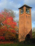
Region 6 War Room 1.JPG
Surface entrance building to the former Region 6 War Room
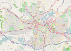
Location map United Kingdom Reading.png
Red pog.svg
Location within Reading
General information
Type Nuclear bunker
Location Reading, Berkshire, UK
Coordinates 51°26′20″N0°56′04″W / 51.4390°N 0.9345°W / 51.4390; -0.9345
Construction started1950s
Listed Building – Grade II
Official nameReading War Room ('The Citadel'), University of Reading
Designated10 March 2009
Reference no. 1393194

The Region 6 War Room is a nuclear bunker dating from the early days of the Cold War, on the Whiteknights Park campus of the University of Reading in the English town of Reading. It is one of a number of such Regional War Rooms built during the 1950s and designed to co-ordinate civil defence in the event of an attack on the country using conventional bombs or atom bombs. [1]

In the event of war, the war room would have housed the Regional Commissioner and his staff who would have directed the strategic response to air raids throughout the counties of Berkshire, Buckinghamshire, Dorset, Hampshire, Oxfordshire, and the Isle of Wight. The Regional Commissioner had the authority to assume the full powers of the central government in this region if contact with central government was lost. [1] [2]

The war room takes the form of a two-level windowless building, with the upper level being above ground level and protected by massive concrete walls, while the lower level is below ground level. The building is surmounted by towers containing filtration equipment. The bunker was designed to cope with attacks by weapons of the type used during the atomic bombings of Hiroshima and Nagasaki during World War II. [1]

The development of the hydrogen bomb and the expectation of mutually assured destruction meant that the war room was both inadequately protected, and seen as too small to support the large live-in staff that would be needed after a major nuclear strike. Its principal responsibilities were transferred to a new Regional Seat of Government 6 (RSG-6) at Warren Row near Maidenhead. Some sources suggest that it continued in use as a civil defence communications centre for some period after this transfer. [1]

After ceasing to be used for civil defence purposes, the war room was taken over by the University and modified as a secure storage facility for use by the University Library. The building still exists, and can be found to the rear of the Department of Agriculture building, near the Earley Gate to the University's Whiteknights Campus. There is no public access to the interior of the building.[ citation needed ]

In the University's updated development plan announced in autumn 2007, the bunker was marked as being scheduled for demolition, along with the wartime 'temporary office buildings'. The land was to be used for a car park. [3]

However, in March 2009, the threatened building received a Grade II heritage listing and is now protected. [4]

Related Research Articles

Civil Defence centres are administration, communication and logistics command centres built in the United Kingdom by the British Government for use in the event of war or serious emergency. During World War II they were often called Air Raid Precautions (ARP) centres. During the Cold War they were also called controls or emergency centres, or popularly nuclear bunkers.

<span class="mw-page-title-main">Pear Tree House</span>

Pear Tree House was the former Civil Defence control centre for South-East London. It is a block of council flats in the Central Hill Estate of Upper Norwood with eight two-bedroom flats and the control centre in the basement.

A number of military citadels are known to have been constructed underground in central London, dating mostly from the Second World War and the Cold War. Unlike traditional above-ground citadels, these sites are primarily secure centres for defence coordination.

<span class="mw-page-title-main">ROTOR</span> 1950s British air defence radar system

ROTOR was an elaborate air defence radar system built by the British Government in the early 1950s to counter possible attack by Soviet bombers. To get it operational as quickly as possible, it was initially made up primarily of WWII-era systems, notably the original Chain Home radars for the early warning role, and the AMES Type 7 for plotting and interception control. Data from these stations was sent to a network of control stations, mostly built underground, using an extensive telephone and telex network.

<span class="mw-page-title-main">Diefenbunker</span> Diefenbunker, Canadas Cold War Museum in Carp, Ontario

The Diefenbunker, formerly known by its military designation, Canadian Forces Station Carp (CFS Carp), is a large underground four-storey reinforced concrete bunker and nuclear fallout shelter located in the rural area of Carp, Ontario approximately 30 km (19 mi) west of downtown Ottawa. Between 1957 and 1961, during the Cold War the Government of Canada led by then Prime Minister John Diefenbaker authorized the Diefenbunker to be designed and built as the Central Emergency Government Headquarters (CEGHQ Carp) in an attempt to ensure the continuity of government subsequent to a nuclear weapons attack by the Soviet Union. In 1994, CFS Carp was decommissioned and closed.

<span class="mw-page-title-main">RAF Daws Hill</span> Ministry of Defence site

RAF Daws Hill was a Ministry of Defence site, located near High Wycombe and Flackwell Heath, in Buckinghamshire, England, close to the M40 motorway.

<span class="mw-page-title-main">Whiteknights Park</span> Main campus of the University of Reading, Reading, UK

Whiteknights Park, or the Whiteknights Campus of the University of Reading, is the principal campus of that university. The park covers the area of the manor of Earley Whiteknights, also known as Earley St Nicholas and Earley Regis.

<span class="mw-page-title-main">Paddock (war rooms)</span> Alternate U.K. Cabinet War Room bunker, 1939-1944

Paddock is the codeword for an alternative Cabinet War Room bunker for Winston Churchill's World War II government, located at 109 Brook Road, Dollis Hill, northwest London, NW2 7DZ; under a corner of the Post Office Research Station site.

<span class="mw-page-title-main">Baddington</span> Human settlement in England

Baddington is a civil parish in the unitary authority of Cheshire East and the ceremonial county of Cheshire, England, which lies immediately to the south-west of Nantwich and north of Audlem. Predominantly rural with scattered farms, the civil parish has a total population of around 100 people, increasing to 212 at the 2011 Census, and includes the dispersed settlement of Hack Green, the site of a former RAF decoy station, radar station and Home Defence regional headquarters. Nearby villages include Aston, Broomhall Green, Hankelow, Ravensmoor, Sound Heath and Stapeley.

<span class="mw-page-title-main">Central Government War Headquarters</span> Underground complex in Wiltshire, England

The Central Government War Headquarters (CGWHQ) is a 35-acre (14 ha) complex built 120 feet (37 m) underground as the United Kingdom's emergency government war headquarters – the hub of the country's alternative seat of power outside London during a nuclear war or conflict with the Soviet Union. It is in Corsham, Wiltshire, in a former Bath stone quarry known as Spring Quarry, under the present-day MoD Corsham. In 1940, during the Second World War, the site was acquired by the Minister of Aircraft Production and used as an underground engine factory. The war headquarters was commissioned in 1955, after approval by Prime Minister Anthony Eden. However, it became outdated shortly after it was built, due to intercontinental ballistic missiles being able to target it, and the formulation of other plans. Nevertheless, the complex continued to have a role in war plans and remained in operation for 30 years.

<span class="mw-page-title-main">Hack Green Secret Nuclear Bunker</span> Former government-owned nuclear bunker in Cheshire, England

The Hack Green Secret Nuclear Bunker is a former government-owned nuclear bunker located at Hack Green, Cheshire, England.

<span class="mw-page-title-main">RAF Rudloe Manor</span> Former Royal Air Force station in Wiltshire, England

RAF Rudloe Manor, formerly RAF Box, was a Royal Air Force station north-east of Bath, England, between the settlements of Box and Corsham, in Wiltshire. It was one of several military installations in the area and covered three dispersed sites. Parts of the site are now used by Defence Digital within the MoD Corsham complex; other areas are vacant and some have been sold, including the 17th-century manor house, Rudloe Manor.

Regional seats of government or RSGs were the best known aspect of Britain's civil defence preparations against nuclear war. In fact, however, naming conventions changed over the years as strategies in Whitehall changed.

<span class="mw-page-title-main">Kelvedon Hatch Secret Nuclear Bunker</span> ROTOR air defence control bunker converted to a Regional Seat of Government

The Kelvedon Hatch Secret Nuclear Bunker at Kelvedon Hatch, in the Borough of Brentwood in the English county of Essex, is a large underground bunker maintained during the Cold War as a potential regional government headquarters. Since being decommissioned in 1992, the bunker has been open to the public as a tourist attraction, with a museum focusing on its Cold War history.

<span class="mw-page-title-main">Barnton Quarry</span> Disused stone quarry in Edinburgh, Scotland

Barnton Quarry is a disused stone quarry in Corstorphine Hill, Clermiston, Edinburgh, Scotland. The site was later used as a military command centre, and is now being converted into a museum.

<span class="mw-page-title-main">Chilmark, Wiltshire</span> Human settlement in England

Chilmark is a Wiltshire village and civil parish of some 150 houses straddling the B3089 road, 11 miles (18 km) west of Salisbury, England. The parish includes the hamlets of Mooray and Portash, both close to the south of Chilmark village; and the dispersed hamlet of Ridge, to the southwest.

<span class="mw-page-title-main">Wartime Broadcasting Service</span> Service of the BBC to be broadcast in preparation of a nuclear war

The Wartime Broadcasting Service is a service of the BBC that is intended to broadcast in the United Kingdom either after a nuclear attack or if conventional bombing destroyed regular BBC facilities in a conventional war. It is unclear if the Wartime Broadcasting Service is still operational as plans are kept mainly secretly with the BBC and government officials. According to an article by the BBC, recordings of a nuclear attack warning are still re-recorded and kept up to date periodically.

<span class="mw-page-title-main">RAF Portland</span>

Royal Air Force Portland or more simply RAF Portland is a former Royal Air Force and ROTOR radar station on the Isle of Portland, Dorset, England. Located close to the Verne Citadel and East Cliff, the station was established in the 1950s as part of a nationwide air defence radar system built by the British Government during the Cold War. The station became a scheduled monument in 2004 and is now the site of the community farm, Fancy's Family Farm.

Brandsby Royal Observer Corps monitoring post is a historic site in Crayke, a village in North Yorkshire, in England.

References

  1. 1 2 3 4 "Reading War Room - Region 6". Subterranea Britannica. Retrieved 12 May 2006.
  2. "The Regional War Rooms: 1950's". Subterranea Britannica. Retrieved 12 May 2006.
  3. "Whiteknights Development Plan". University of Reading. Retrieved 11 November 2007.
  4. Historic England (10 March 2009). "Reading War Room ('The Citadel'), University of Reading (Grade II) (1393194)". National Heritage List for England .