Related Research Articles

The Snowball Earth is a geohistorical hypothesis that proposes during one or more of Earth's icehouse climates, the planet's surface became entirely or nearly entirely frozen with no liquid oceanic or surface water exposed to the atmosphere. The most academically referred period of such global glaciation is believed to have occurred sometime before 650 mya during the Cryogenian period.

A moraine is any accumulation of unconsolidated debris, sometimes referred to as glacial till, that occurs in both currently and formerly glaciated regions, and that has been previously carried along by a glacier or ice sheet. It may consist of partly rounded particles ranging in size from boulders down to gravel and sand, in a groundmass of finely-divided clayey material sometimes called glacial flour. Lateral moraines are those formed at the side of the ice flow, and terminal moraines were formed at the foot, marking the maximum advance of the glacier. Other types of moraine include ground moraines and medial moraines.

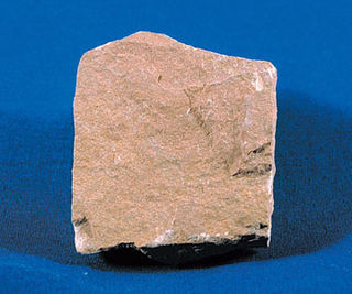
Till or glacial till is unsorted glacial sediment.
Siltstone, also known as aleurolite, is a clastic sedimentary rock that is composed mostly of silt. It is a form of mudrock with a low clay mineral content, which can be distinguished from shale by its lack of fissility.

Glacial landforms are landforms created by the action of glaciers. Most of today's glacial landforms were created by the movement of large ice sheets during the Quaternary glaciations. Some areas, like Fennoscandia and the southern Andes, have extensive occurrences of glacial landforms; other areas, such as the Sahara, display rare and very old fossil glacial landforms.
Diamicton is a terrigenous sediment that is unsorted to poorly sorted and contains particles ranging in size from clay to boulders, suspended in an unconsolidated matrix of mud or sand. Today, the word has strong connotations to glaciation but can be used in a variety of geological settings.

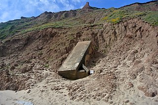
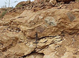
The Varanger Peninsula is a peninsula in Finnmark county, Norway. It is located in the northeasternmost part of Norway, along the Barents Sea. The peninsula has the Tanafjorden to the west, the Varangerfjorden to the south, and the Barents Sea to the north and east. The municipalities of Vadsø, Båtsfjord, Berlevåg, Vardø, Tana, and Nesseby share the 2,069-square-kilometre (799 sq mi) peninsula. Nesseby and Tana are only partially on the peninsula, with the rest being entirely on the peninsula. The Varangerhalvøya National Park protects most of the land on the peninsula.
Boulder clay is an unsorted agglomeration of clastic sediment that is unstratified and structureless and contains gravel of various sizes, shapes, and compositions distributed at random in a fine-grained matrix. The fine-grained matrix consists of stiff, hard, pulverized clay or rock flour. Boulder clay is also known as either known as drift clay; till; unstratified drift, geschiebelehm (German); argile á blocaux (French); and keileem (Dutch).

The Roxbury Conglomerate, also informally known as Roxbury puddingstone, is a name for a rock formation that forms the bedrock underlying most of Roxbury, Massachusetts, now part of the city of Boston. The bedrock formation extends well beyond the limits of Roxbury, underlying part or all of Quincy, Canton, Milton, Dorchester, Dedham, Jamaica Plain, Brighton, Brookline, Newton, Needham, and Dover. It is named for exposures in Roxbury, Boston area. It is the Rock of the Commonwealth in Massachusetts.
Diamictite is a type of lithified sedimentary rock that consists of nonsorted to poorly sorted terrigenous sediment containing particles that range in size from clay to boulders, suspended in a matrix of mudstone or sandstone. The term was coined by Richard Foster Flint and others as a purely descriptive term, devoid of any reference to a particular origin. Some geologists restrict the usage to nonsorted or poorly sorted conglomerate or breccia that consists of sparse, terrigenous gravel suspended in either a mud or sand matrix.
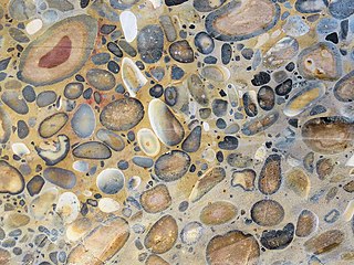
Puddingstone, also known as either pudding stone or plum-pudding stone, is a popular name applied to a conglomerate that consists of distinctly rounded pebbles whose colours contrast sharply with the colour of the finer-grained, often sandy, matrix or cement surrounding them. The rounded pebbles and the sharp contrast in colour gives this type of conglomerate the appearance of a raisin or Christmas pudding. There are different types of puddingstone, with different composition, origin, and geographical distribution. Examples of different types of puddingstones include the Hertfordshire, Schunemunk, Roxbury, and St. Joseph Island puddingstones.
Called the Windermere Group in the United States and the Windermere Supergroup, Windermere Series, and Windermere System in Canada, the Windermere sequence of North America is an extensive assemblage of sedimentary and volcanic rocks of latest Precambrian (Neoproterozoic) age. It is present in the northern part of the North American Cordillera, stretching from Montana, Idaho, and Washington in the northwestern United States, through Alberta, British Columbia, the Northwest Territories, and the Yukon in western Canada. It was named for the Windermere map-area in the East Kootenay region of southeastern British Columbia by J.F. Walker in 1926.
The Marinoan glaciation, sometimes also known as the Varanger glaciation, was a period of worldwide glaciation. Its beginning is poorly constrained, but occurred no earlier than 654.5 Ma. It ended approximately 632.3 ± 5.9 Ma during the Cryogenian period. This glaciation possibly covered the entire planet, in an event called the Snowball Earth. The end of the glaciation was caused by volcanic release of carbon dioxide and dissolution of gas hydrates and might have been hastened by the release of methane from equatorial permafrost.
Mount Ritchie is a mountain rising over 1600 m in the southeast part of Warren Range, Antarctica. The feature is 5.6 km (3 nmi) northeast of Wise Peak on the west side of Deception Glacier. Named by the Victoria University of Wellington Antarctic Expedition (VUWAE), 1970–71, after Alex Ritchie, curator of fossils at the Australian Museum, Sydney, a member of the VUWAE party that discovered important sites of fossil fish in this Skelton Neve area.

The Dwyka Group is one of four geological groups that compose the Karoo Supergroup. It is the lowermost geological group and heralds the commencement of sedimentation of the Karoo Supergroup. Based on stratigraphic position, lithostratigraphic correlation and palynological analyses, these lowermost Karoo strata range between the Late Carboniferous (Pennsylvanian) to Early Permian in age.
The Sturtian glaciation was a worldwide glaciation during the Cryogenian Period when the Earth experienced repeated large-scale glaciations. As of January 2023, the Sturtian glaciation is thought to have lasted from c. 717 Ma to c. 660 Ma, a time span of approximately 57 million years. It is hypothesised to have been a Snowball Earth event, or contrastingly multiple regional glaciations, and is the longest and most severe known glacial event preserved in the geologic record, after the much earlier Huronian glaciation.
The Gaskiers glaciation is a period of widespread glacial deposits that lasted under 340 thousand years, between 579.63 ± 0.15 and 579.88 ± 0.44 million years ago — i.e. late in the Ediacaran Period — making it the last major glacial event of the Precambrian. It was also the last and the shortest of at least three major ice ages in the Neoproterozoic era. It is assumed that, in contrast to the Sturtian and Marinoan periods, it did not lead to global glaciation.
The geology of Niger comprises very ancient igneous and metamorphic crystalline basement rocks in the west, more than 2.2 billion years old formed in the late Archean and Proterozoic eons of the Precambrian. The Volta Basin, Air Massif and the Iullemeden Basin began to form in the Neoproterozoic and Paleozoic, along with numerous ring complexes, as the region experienced events such as glaciation and the Pan-African orogeny. Today, Niger has extensive mineral resources due to complex mineralization and laterite weathering including uranium, molybdenum, iron, coal, silver, nickel, cobalt and other resources.
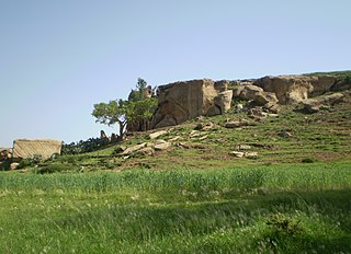
The Enticho Sandstone is a geological formation in north Ethiopia. It forms the lowermost sedimentary rock formation in the region and lies directly on the basement rocks. Enticho Sandstone consists of arenite that is rich in quartz. The formation has a maximum thickness of 200 metres. Locally, its upper part is coeval with the Edaga Arbi Glacials. The Enticho Sandstone has been deposited during the Ordovician, as evidenced by impressions of organisms.
The Edaga Arbi Glacials are a Palaeozoic geological formation in Tigray and in Eritrea. The matrix is composed of grey, black and purple clays, that contains rock fragments up to 6 metres across. Pollen dating yields a Late Carboniferous to Early Permian age.
References
- 1 2 Hoffman, Paul F. (2011). "A history of Neoproterozoic glacial geology, 1871– 1997". In Arnaud, E.; Halverson, G.P.; Shields-Zhou, G. (eds.). The Geological Record of Neoproterozoic Glaciations. Geological Society, London, Memoirs. Geological Society of London. pp. 17–37.
- 1 2 3 Jensen, P.A.; Wulff-Pedersen, E. (1996). "Glacial or non-glacial origin for the Bigganjargga tillite, Finnmark, northern Norway". Geological Magazine. 133 (2): 137–145. Bibcode:1996GeoM..133..137J. doi:10.1017/s0016756800008657. S2CID 129260708.
- 1 2 3 Arnaud, Emmanuelle; Eyles, Carolyn H. (2002). "Glacial influence on Neoproterozoic sedimentation: the Smalfjord Formation, northern Norway". Sedimentology. 49 (4): 765–788. Bibcode:2002Sedim..49..765A. doi:10.1046/j.1365-3091.2002.00466.x. S2CID 128719279.
- 1 2 Edwards, Marc B. (2004). "Glacial influence on Neoproterozoic sedimentation: the Smalfjord Formation, northern Norway – discussion". Sedimentology. 51 (6): 1409–1417. Bibcode:2004Sedim..51.1409E. doi:10.1111/j.1365-3091.2004.00674.x. S2CID 128612530.
- ↑ Bjørlykke, Knut (1967). "The Eocambrian Reusch moraine at Bigganjargga and the geology around Varangerfjord; northern Norway". Studies on the latest Precambrian and Eocambrian Rocks in Norway (PDF). Universitetsforlaget. p. 20.
- ↑ "Discussion of glacial or non-glacial origin for the Bigganjargga tillite, Finnmark, northern Norway". Geological Magazine. 134 (6): 873–876. 1997. doi: 10.1017/s0016756897007607 . S2CID 248521010.
70°07′15″N28°49′05″E / 70.1207°N 28.8181°E