Reynolds Peak (California)

Last updated

Reynolds Peak
Reynolds Peak (California).jpg
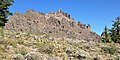
Northeast aspect, from PCT
Highest point
Elevation 9,690 ft (2,954 m) [1] [2]
Prominence 760 ft (232 m) [3]
Parent peak Peak 9860 [4]
Isolation 1.30 mi (2.09 km) [4]
Coordinates 38°34′50″N119°50′19″W / 38.5806389°N 119.8385678°W / 38.5806389; -119.8385678 [5]
Naming
Etymology G. Elmer Reynolds. [6]
Geography
Relief map of California.png
Red triangle with thick white border.svg
Reynolds Peak
Location in California
Usa edcp relief location map.png
Red triangle with thick white border.svg
Reynolds Peak
Reynolds Peak (the United States)
Location Mokelumne Wilderness
CountryUnited States
StateCalifornia
County Alpine
Parent range Sierra Nevada
Topo map USGS Ebbetts Pass
Geology
Rock age Late Tertiary [7]
Rock type Volcanic rock [8]
Climbing
Easiest route class 3 scrambling [4]

Reynolds Peak is a 9,690-foot-elevation (2,950-meter) mountain summit located in Alpine County, California, United States.

Contents

Description

Reynolds Peak is set three miles (4.8 km) northwest of Ebbetts Pass in the Mokelumne Wilderness, on the common boundary that Humboldt–Toiyabe National Forest shares with Stanislaus National Forest. Reynolds Peak is situated on the crest of the Sierra Nevada mountain range, with precipitation runoff from the peak draining west to the North Fork Mokelumne River, and east into tributaries of the East Fork Carson River. Topographic relief is modest as the east aspect rises 1,100 feet (340 meters) above Raymond Meadows in one-half mile. Neighbors include Raymond Peak 1.7 miles (2.7 km) to the north and Highland Peak, 5.1 miles (8.2 km) southeast. The Pacific Crest Trail traverses the eastern base of the mountain, providing an approach option from Ebbetts Pass.

Etymology

Reynolds in 1926 G. Elmer Reynolds.tif
Reynolds in 1926

At the recommendation of the US Forest Service, this landform's toponym was officially adopted in 1929 by the U.S. Board on Geographic Names to honor Gilbert Elmer Reynolds (1884–1928), for many years the managing editor of the Stockton Record and an advocate of forest conservation. [5] He was a member of the Sierra Club and one of California's leading conservationists. [9] [10]

Climate

According to the Köppen climate classification system, Reynolds Peak is located in an alpine climate zone. [11] Most weather fronts originate in the Pacific Ocean and travel east toward the Sierra Nevada mountains. As fronts approach, they are forced upward by the peaks (orographic lift), causing them to drop their moisture in the form of rain or snowfall onto the range.

See also

References

  1. Peter Browning, Place Names of the Sierra Nevada: From Abbot to Zumwalt, 1986, Wilderness Press, ISBN   9780899970479, p. 182
  2. United States Board on Geographic Names (1979), Decisions on Geographic Names in the United States, List 7902, Department of the Interior, p. 8
  3. "Reynolds Peak, California". Peakbagger.com. Retrieved July 17, 2022.
  4. 1 2 3 "Reynolds Peak - 9,700' CA". listsofjohn.com. Retrieved July 17, 2022.
  5. 1 2 "Reynolds Peak". Geographic Names Information System . United States Geological Survey, United States Department of the Interior . Retrieved July 17, 2022.
  6. Erwin G. Gudde, William Bright (2010), California Place Names: The Origin and Etymology of Current Geographical Names, University of California Press, ISBN   9780520266193, p. 315.
  7. David A. John (1984), U.S. Geological Survey Professional Paper, Issue 1300, Part 1, U.S. Government Printing Office, p. 235
  8. Vicky Spring (2004), 100 Hikes in California's Central Sierra and Coast Range, 2nd Ed., The Mountaineers Books, ISBN   9781594851902, p. 50
  9. United States Board on Geographic Names (June 5, 1929), Decisions on Geographic Names in the United States, p. 4
  10. Sierra Club Bulletin (1928), Volume 13, p. 128
  11. "Climate of the Sierra Nevada". Encyclopædia Britannica .