
Adams County is a county in the U.S. state of Washington. As of the 2020 census, the population was 20,613. The county seat is at Ritzville, and its largest city is Othello. The county was formed out of Whitman County in November 1883 and is named after John Adams, the second President of the United States.

Ritzville is a city in Adams County, Washington, United States. The population was 1,767 at the 2020 census. It is the county seat of Adams County. The city is part of the Othello, WA Micropolitan Area, which comprises all of Adams County, and is part of the larger Moses Lake-Othello, WA Combined Statistical Area.

Woodford is a large village and civil parish located in North Northamptonshire, England. At the time of the 2011 census, the parish's population was 1,461 people.
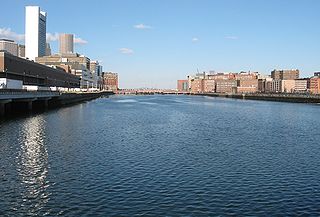
Fort Point Channel is a maritime channel separating South Boston from downtown Boston, Massachusetts, feeding into Boston Harbor. The south part of it has been gradually filled in for use by the South Bay rail yard and several highways. At its south end, the channel once widened into South Bay, from which the Roxbury Canal continued southwest where the Massachusetts Avenue Connector is now. The Boston Tea Party occurred at its northern end. The channel is surrounded by the Fort Point neighborhood, which is also named after the same colonial-era fort.

San Fernando Road is a major street in the City of Los Angeles and Los Angeles County. Within the Burbank city limits it is signed as San Fernando Boulevard, and north of Newhall Pass it is signed as The Old Road. It was previously designated as Business Loop 5 in the 1970s.
Purcell & Elmslie (P&E) was the most widely know iteration of a progressive American architectural practice. P&E was the second most commissioned firm of the Prairie School, after Frank Lloyd Wright. The firm in all iterations was active from 1907 to 1921, with their most famous work being done between 1913 and 1921.

Firth Court is a Grade II listed Edwardian red-brick building that forms part of the Western Bank Campus of the University of Sheffield in the United Kingdom. Located on the northern side of Western Bank, it is the main administrative centre for the university and also houses the Departments of Molecular Biology and Biotechnology and Biomedical Science.
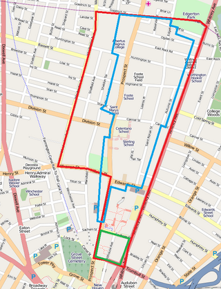
Prospect Hill is a neighborhood of the city of New Haven, Connecticut located in the north central portion of the city, directly north of Downtown New Haven. The neighborhood contains residences, institutional buildings of Albertus Magnus University and a portion of the main campus of Yale University, including the Science Hill area, the Hillhouse Avenue area and the Yale Peabody Museum. The City of New Haven defines the neighborhood to be the region bounded by the town of Hamden in the north, Winchester Avenue in the west, Munson Street/Hillside Place/Prospect Street in the southwest, Trumbull Street in the south, and Whitney Avenue in the east. Prospect Street is the main thoroughfare through the neighborhood.

Bungalow Heaven is a neighborhood in Pasadena, California named for the more than 800 small craftsman homes built there from 1900 to 1930, most of which still stand. Much of the area became a landmark district in 1989 and annual historic home tours have been conducted in Bungalow Heaven every year since then.
Main Street is a major north–south thoroughfare in Los Angeles, California. It serves as the east–west postal divider for the city and the county as well.

The Downtown Aledo Historic District is a national historic district located in downtown Aledo, Illinois. The district includes 75 contributing buildings and a park. The majority of the buildings are commercial structures, but the district also includes the city's Chicago, Burlington and Quincy Railroad station and both the city's and Mercer County's major government buildings. Development in the district began in the 1850s, and the oldest surviving buildings date from the following decade. The district includes examples of many prominent American architectural styles from the mid-19th century onward; the most prevalent styles are Classical Revival, Romanesque Revival, and Italianate.

The Carville Historic District in Carville, Louisiana, is a 60-acre (24 ha) historic district that was listed on the National Register of Historic Places on November 18, 1992. It formerly served as a treatment facility for leprosy, and was called the National Leprosarium, Gillis W. Long Hansen's Disease Center and Public Health Service Hospital No. 66.
The Downtown Wenatchee Historic District, located in Wenatchee, Washington, is a historic district listed on the National Register of Historic Places. The district, encompassing 34 acres (14 ha), is a collection of commercial, mixed-used, and warehouse buildings located in the central business district of Wenatchee downtown. It contains a total of 57 contributing and 32 noncontributing properties.

The Downtown Ruston Historic District is a historic district located in downtown Ruston, Louisiana.
The late-Victorian-era Downtown of Los Angeles in 1880 was centered at the southern end of the Los Angeles Plaza area, and over the next two decades, it extended south and west along Main Street, Spring Street, and Broadway towards Third Street. Most of the 19th-century buildings no longer exist, surviving only in the Plaza area or south of Second Street. The rest were demolished to make way for the Civic Center district with City Hall, numerous courthouses, and other municipal, county, state and federal buildings, and Times Mirror Square. This article covers that area, between the Plaza, 3rd St., Los Angeles St., and Broadway, during the period 1880 through the period of demolition (1920s–1950s).
The Bird's Nest in Shelby County, Kentucky, about 3 miles (4.8 km) south of Cropper, Kentucky, was built c.1850.

