Roads & Traffic Authority

Last updated

Roads & Traffic Authority
RTA Old Logo.gif
RTA logo from 1989 until 2009
Statutory authority overview
Formed16 January 1989
Preceding agencies
Dissolved31 October 2011
Superseding agency
Jurisdiction New South Wales
Headquarters Sydney
Employees7.523 (June 2011)
Annual budget A$4.8 billion (2011)
Statutory authority executive
  • Michael Bushby, CEO
Key document
Website www.rta.nsw.gov.au/
Logo used by RTA between 2009 and 2011, which includes the NSW government's Waratah emblem NewRTALogo.tiff
Logo used by RTA between 2009 and 2011, which includes the NSW government's Waratah emblem

The Roads & Traffic Authority (RTA) was an agency of the Government of New South Wales responsible for major road infrastructure, licensing of drivers, and registration of motor vehicles. The RTA directly managed state roads and provided funding to local councils for regional and local roads. In addition, with assistance from the federal government, the RTA also managed the NSW national highway system. The agency was abolished in 2011 and replaced by Roads & Maritime Services.

Contents

History

The Department of Main Roads (DMR) was established in November 1932, and undertook works across New South Wales, including maintenance of all major roads into Sydney and programs of road reconstruction, construction, upgrading and rerouting. The DMR was also responsible for many ferries and bridges in New South Wales. [1]

On 16 January 1989, the Department of Main Roads, Department of Motor Transport, and the Traffic Authority were amalgamated to form the Roads & Traffic Authority under the Transport Administration Act, No. 109, 1988 (NSW).

On 1 November 2011, the Roads & Traffic Authority merged with NSW Maritime to become Roads & Maritime Services (RMS). [2] Planning and co-ordination functions were transferred to Transport for NSW. On 1 December 2019 the RMS was dissolved by act of parliament and merged with Transport for NSW.

Regions of the RTA

RTA South West Region offices in Wagga Wagga RTA South West Region offices.jpg
RTA South West Region offices in Wagga Wagga

The Roads & Traffic Authority was divided into six regions:

Functions

The Roads & Traffic Authority had managed 4,787 bridges and 17,623 km (10,950 mi) of state roads and highways, including 3,105 km (1,929 mi) of national highways, and employed 6,900 staff in more than 180 offices throughout NSW, including 129 Motor Registries Offices.

Vehicle registration

RTA Motor Registry Office in Wagga Wagga RTA Motor Registry Office.jpg
RTA Motor Registry Office in Wagga Wagga

The RTA was responsible for the registration of vehicles (including the issuing of registration plates) and the issuing of drivers licences in New South Wales, including testing and administering of licences. Additionally, the RTA produced photo cards for identification of non-drivers and issued photographic firearms licences for the New South Wales Police Firearms Registry, security licences for the New South Wales Police, Commercial Agents & Private Inquiry Agents cards and mobility parking permits.

Major incident response

Within NSW, the Transport Management Centre was responsible for managing special events and unplanned incidents and disseminating information to motorists. It is the central point for identifying and directing the response to incidents such as crashes, breakdowns and spills. It passes on information to the public through the media, the RTA call centre and variable message signs along routes. [3]

In 1999 the NSW Transport Management Centre (TMC) established Traffic Commander and Traffic Emergency Patrol (TEP) services throughout the Greater Urban Area of Sydney to provide 24-hour 365-day-a-year coverage to "Manage the traffic arrangements around an incident scene and return the road to normal operating conditions with the utmost urgency." [4]

Traffic commanders took command of traffic management arrangements at an incident (such as a motor vehicle collision) and liaise with other response agencies such as the police, and assist in clearing the road and minimising the effects and disruption to traffic. [5] Traffic Emergency Patrols vans patrolled major road routes and respond to unplanned incidents with the aim of returning the road to normal operating conditions as soon as possible. [4] Both traffic commanders and TEP units carry a wide array of traffic management devices such as traffic cones, barrier boards and road signage. [6] Both also are permitted to use and display red and blue emergency lighting and are designated as 'emergency vehicles'. [7]

Completed projects

Ferry services

Wisemans Ferry Wisemans Ferry.jpg
Wisemans Ferry

The RTA was responsible for the provision of several car ferries, all of which were toll-free, including: [9] [10]

Related Research Articles

<span class="mw-page-title-main">Princes Highway</span> Highway in Australia

Princes Highway is a major road in Australia, extending from Sydney via Melbourne to Adelaide through the states of New South Wales, Victoria and South Australia. It has a length of 1,941 kilometres (1,206 mi) or 1,898 kilometres (1,179 mi) via the former alignments of the highway, although these routes are slower and connections to the bypassed sections of the original route are poor in many cases.

<span class="mw-page-title-main">Pacific Highway (Australia)</span> Highway in New South Wales and Queensland

Pacific Highway is a 790-kilometre-long (491 mi) national highway and major transport route along the central east coast of Australia, with the majority of it being part of Australia's Highway 1. The highway and its adjoining Pacific Motorway between Brisbane and Brunswick Heads and Pacific Motorway between Sydney and Newcastle links the state capitals of Sydney in New South Wales with Brisbane in Queensland, approximately paralleling the Tasman Sea and the Coral Sea of the South Pacific Ocean coast, via regional cities and towns like Gosford, Newcastle, Taree, Port Macquarie, Kempsey, Coffs Harbour, Grafton, Ballina, Byron Bay, Tweed Heads and the Gold Coast, which is part of Queensland. Additionally, between Brunswick Heads and Port Macquarie, the road is also signed as Pacific Motorway, but has not been legally gazetted as such.

<span class="mw-page-title-main">Hawkesbury River</span> River in New South Wales, Australia

The Hawkesbury River, or Hawkesbury-Nepean River, is a river located northwest of Sydney, New South Wales, Australia. The Hawkesbury River and its associated main tributary, the Nepean River, almost encircle the metropolitan region of Sydney. Between Wisemans Ferry and the Pacific Ocean marks the boundary of Greater Metropolitan Sydney in the south and the Central Coast region to the north.

<span class="mw-page-title-main">Hornsby Shire</span> Local government area in New South Wales, Australia

Hornsby Shire is a local government area situated in Northern Sydney, as well as parts of the Hills District, in the state of New South Wales, Australia. The shire stretches from the M2 Hills Motorway in the south to the Hawkesbury River town of Wisemans Ferry, some 53 kilometres (33 mi) to the north, making it the largest local government council in the Greater Sydney Metropolitan region by total area. As of the 2016 census the shire had an estimated population of 142,667.

<span class="mw-page-title-main">Pacific Motorway (Sydney–Newcastle)</span> Motorway in New South Wales, Australia

The M1 Pacific Motorway is a 127-kilometre motorway linking Sydney to Newcastle via the Central Coast and Hunter regions of New South Wales. Formerly known but still commonly referred to by both the public and the government as the F3 Freeway, Sydney–Newcastle Freeway, and Sydney–Newcastle Expressway, it is part of the AusLink road corridor between Sydney and Brisbane. The name "F3 Freeway" reflects its former route allocation before it was decommissioned and replaced by the rollout of alphanumeric signposts.

<span class="mw-page-title-main">Bells Line of Road</span> Road in New South Wales, Australia

Bells Line of Road is a 59-kilometre (37 mi) major road located in New South Wales, Australia, providing an alternative crossing of the Blue Mountains to the Great Western Highway. The eastern terminus of the road is in Richmond, 51 km northwest of Sydney, where the road continues eastward as Kurrajong Road, which intersects the A9. The western terminus of the road is in Bell, in the Blue Mountains, where the road continues as the Chifley Road.

<span class="mw-page-title-main">Wisemans Ferry, New South Wales</span> Town in New South Wales, Australia

Wisemans Ferry is a town on the northern outskirts of Sydney and the south-west of the Central Coast region in the state of New South Wales, Australia, located 75 kilometres north north-west of Sydney. It is located in the Sydney local government areas of the Hornsby Shire, The Hills Shire, City of Hawkesbury and the Central Coast local government area of Central Coast Council. The town is a tourist spot with picnic and barbecue facilities. As well as a rich convict and colonial heritage in the area, the Dharug National Park and Yengo National Park are close by.

<span class="mw-page-title-main">Wisemans Ferry</span> Cable ferry in NSW, Australia

Wisemans Ferry is a cable ferry across the Hawkesbury River in New South Wales, Australia. The ferry operates from the eponymous community of Wisemans Ferry on the south bank, to a point on the north bank downstream of the Hawkesbury River's confluence with the Macdonald River, connecting with the old Great North Road. The crossing has remained in use on its current site since 1829, making it the oldest ferry crossing still in operation in New South Wales, and possibly in Australia.

<span class="mw-page-title-main">M5 Motorway (Sydney)</span> Motorway in Sydney, Australia

The M5 Motorway is a 29-kilometre (18 mi) motorway located in Sydney, New South Wales that is part of the Sydney Orbital Network.

<span class="mw-page-title-main">Transport in Sydney</span> Overview of transport in Sydney, Australia

Transport in Sydney is provided by an extensive network of public transport operating modes including metro, train, bus, ferry and light rail, as well as an expansive network of roadways, cycleways and airports. According to the 2006 census, in terms of travel to work or study Sydney has the highest rate of public transport usage among the Australian capital cities of 26.3% with more than 80% of weekday trips to/from Central Sydney being made by public transport. According to the New South Wales State Plan, the state has Australia's largest public transport system. The public transport network is regulated by Transport for NSW.

The Mortlake Ferry, also known as the Putney Punt, is a cable ferry that runs across the Parramatta River in Sydney, connecting Hilly Street in Mortlake and Pellisier Road in Putney.

<span class="mw-page-title-main">Mooney Mooney Bridge</span> Bridge in New South Wales, Australia

The Mooney Mooney Bridge, officially the Mooney Mooney Creek Bridge, and popularly known as The NSW Big Dipper Bridge, is a twin cantilever bridge that carries the Pacific Motorway (M1) across Mooney Mooney Creek, located near Mooney Mooney in the Brisbane Water National Park on the Central Coast of New South Wales, Australia. The concrete box girder bridge was opened on 14 December 1986 by the Prime Minister of Australia, Bob Hawke, and is owned and maintained by Transport for NSW, an agency of the Government of New South Wales.

<span class="mw-page-title-main">Sackville Ferry</span> Suburb of City of Hawkesbury, New South Wales, Australia

The Sackville Ferry is a cable ferry across the Hawkesbury River in New South Wales, Australia. The vehicular ferry connects the communities of Sackville, on the north/west bank of the river, and Sackville North, on the south/east bank. Because of the tortuous course of the river, the ferry actually runs north-west from Sackville to Sackville North.

<span class="mw-page-title-main">Webbs Creek Ferry</span> Cable ferry across the Hawkesbury River in New South Wales, Australia

Webbs Creek Ferry is a cable ferry across the Hawkesbury River in New South Wales, Australia. The ferry operates from the community of Wisemans Ferry, to a point up-stream of the Hawkesbury River's confluence with the Macdonald River, thus connecting with St Albans Road that follows the west bank of the Macdonald River.

<span class="mw-page-title-main">Berowra Waters Ferry</span>

The Berowra Waters Ferry is a cable ferry across the Berowra Creek, a tributary of the Hawkesbury River, located in the Berowra Valley National Park, Sydney, Australia. The ferry operates from the community of Berowra Waters on the west bank of the creek, to a landing on the east bank, thus connecting with the road to Berowra Heights.

The Lower Portland Ferry is a cable ferry across the Hawkesbury River in New South Wales, Australia. The ferry is situated in the community of Lower Portland.

<span class="mw-page-title-main">Peats Ferry Bridge</span> Bridge in New South Wales, Australia

The Peats Ferry Bridge is a steel truss bridge that carries the Pacific Highway (B83) across the Hawkesbury River, between Kangaroo Point and Mooney Mooney Point, located 40 kilometres (25 mi) north of Sydney in New South Wales, Australia. The bridge carries the Hornsby to Kariong section of highway, while the adjacent Brooklyn Bridge carries the Pacific Motorway (M1).

<span class="mw-page-title-main">Roads and Maritime Services</span> Australian state government agency

Roads and Maritime Services was an agency of the New South Wales Government responsible for building and maintaining road infrastructure and managing the day-to-day compliance and safety for roads and waterways.

<span class="mw-page-title-main">Windsor Bridge (New South Wales)</span> Bridge in Sydney, New South Wales, Australia

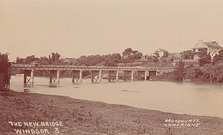
The Windsor Bridge, officially called the Hawkesbury River Bridge, Windsor, a beam bridge across the Hawkesbury River, is located in Windsor in north-western Sydney, New South Wales, Australia. The bridge was built in 1874. On 18 May 2020, the replacement bridge was opened to traffic within Windsor, NSW.

<span class="mw-page-title-main">Brooklyn Bridge, New South Wales</span> Bridge in New South Wales, Australia

The Brooklyn Bridge is a local nickname for the Hawkesbury River Road Bridge, a concrete girder bridge that carries the Pacific Motorway (M1) across the Hawkesbury River between Kangaroo Point to Mooney Mooney Point, located 35 kilometres (22 mi) north of Sydney in New South Wales, Australia. The bridge comprises a dual carriageway with three lanes in each direction of motorway grade-separated conditions.

References

  1. "Dudley Parker Paintings, Parkes". Heritage and conservation register. Roads & Traffic Authority. 30 March 2004. Archived from the original on 25 August 2006. Retrieved 9 September 2008.
  2. "New Roads and Maritime Services Chief Executive" (PDF). Minister for Roads and Ports, Duncan Gay . New South Wales Department of Transport. 14 October 2011. Retrieved 17 October 2011.[ permanent dead link ]
  3. "Annual Report 2002" (PDF). Roads & Traffic Authority.
  4. 1 2 "Re: Dedicated Major Incident Response Team". National Transportation Operations Coalition. 10 September 2001. Archived from the original on 2 September 2005. Retrieved 21 January 2008.
  5. Up for the challenge|Sydney traffic commander Shane Bentley| RTA Archived 9 September 2011 at the Wayback Machine . News.drive.com.au (2010-05-07). Retrieved on 2013-09-07.
  6. Traffic incident response < F3 Freeway < Using roads < Roads and Maritime Services. Rta.nsw.gov.au (3 Novwember 2011). Retrieved on 7 September 2013.
  7. Vehicle standards information 24 November 2010 RTA
  8. "Great Western Highway". Archived from the original on 2 July 2015. Retrieved 3 August 2015.
  9. "Vehicle ferries". Roads & Traffic Authority. Archived from the original on 6 June 2011. Retrieved 18 November 2008.
  10. "Contract Notice RTA.07.2547.0089". Roads & Traffic Authority. Archived from the original on 31 March 2011. Retrieved 27 December 2008.

General

  1. Great Western Highway
  2. Sydney to Melbourne strategy
  3. Hume Highway duplication package
  4. Coolac Bypass
  5. Pacific Highway
  6. Princes Highway strategy.
  7. More completed projects from the RTA

Commons-logo.svg Media related to Roads and Traffic Authority at Wikimedia Commons