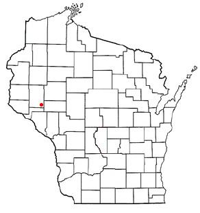
Pierce County is a county located in the U.S. state of Wisconsin. As of the 2010 census, the population was 41,019. Its county seat is Ellsworth.

Rock Falls is a city in Whiteside County, Illinois, United States. The population was 9,266 at the 2010 census, down from 9,580 in 2000. The city is located on the Rock River, directly opposite Sterling.

Chippewa Falls is a city located on the Chippewa River in Chippewa County in the U.S. state of Wisconsin. The most recent census from 2010 shows that the population is 13,661. Incorporated as a city in 1869, it is the county seat of Chippewa County.
Park Falls is a city in Price County, Wisconsin, United States. The population was 2,462 at the 2010 census. Located in the woods of north central Wisconsin, primarily the Chequamegon National Forest, Park Falls is a small community divided by the North Fork of the Flambeau River, a popular destination for fishing, canoeing and whitewater rafting.
Menomonee Falls is a village in Waukesha County, Wisconsin, United States, and is part of the Greater Milwaukee area. The population was 35,626 at the 2010 census, making it the most populous village in Wisconsin. It is the fourth largest community in Waukesha County.

River Falls is a city in Pierce and St. Croix counties in the U.S. state of Wisconsin. It is adjacent to the Town of River Falls in Pierce County and the Town of Kinnickinnic in St. Croix County. River Falls is the most populous city in Pierce county. The population was 15,000 at the 2010 census, with 11,851 residing in Pierce County, and 3,149 in St. Croix County. It is part of the Minneapolis-St. Paul metropolitan area and is about 30 miles (48 km) east of the center of that region.

Sheboygan Falls is a city in Sheboygan County, Wisconsin, United States. Its population was 7,775 at the 2010 census. The city's downtown is listed on the National Register of Historic Places and is the first Main Street Community in Wisconsin. The city is part of the Sheboygan, Wisconsin Metropolitan Statistical Area.

The Rock River is a tributary of the Mississippi River, approximately 299 miles (481 km) long, in the U.S. states of Wisconsin and Illinois. The river was known as the Sinnissippi to Sauk and Fox Indians; the name means "rocky waters".

The Montreal River is a river flowing to Lake Superior in northern Wisconsin and the Upper Peninsula of Michigan in the United States. It is 47.8 miles (76.9 km) long and drains approximately 270 square miles (700 km2) in a forested region. For most of its length, the river's course defines a portion of the Wisconsin–Michigan border. The Ojibwe name for the river is Gaa-waasijiwaang, meaning "where there is whitewater".

The Rush River is a 49.8-mile-long (80.1 km) tributary of the Mississippi River in western Wisconsin in the United States. It rises just north of Interstate 94 in St. Croix County near Baldwin and flows generally southwardly through Pierce County. It ends in Lake Pepin of the Mississippi River, about 1 mile (2 km) west of the village of Maiden Rock in Pierce County. The largest tributary is Lost Creek.

Wilmot is a census-designated place and residential and business community in the village of Salem Lakes in southwestern Kenosha County, Wisconsin, United States. As of the 2010 census, its population is 442. Wilmot has an area of 1.383 square miles (3.58 km2), all of it land.

State Trunk Highway 23 is a state highway in the U.S. state of Wisconsin. The route is signed as a north–south route from Shullsburg to Wisconsin Dells and as an east–west route from Wisconsin Dells to Sheboygan. With the exception of freeway segments between Sheboygan Falls and Sheboygan, an expressway segment between Sheboygan Falls and near Greenbush, a freeway concurrency with I-39, and an expressway segment concurrent with U.S. Route 151, the highway is generally either two-lane surface road or urban multilane arterial. WIS 23 provides access to several important Wisconsin destinations, such as the House on the Rock, the Wisconsin Dells area and various state parks.

Black River Falls is a city in Jackson County, Wisconsin, USA. The population was 3,622 at the 2010 census. It is Jackson County's county seat. The Ho-Chunk Nation has its administrative center in Black River Falls.
Clam Falls is an unincorporated community located in the town of Clam Falls, Polk County, Wisconsin, United States. Clam Falls is 8.5 miles (13.7 km) east-northeast of Frederic.
Cedar Falls is an unincorporated community located in the town of Red Cedar, Dunn County, Wisconsin, United States. Cedar Falls is located along the Red Cedar River 4.5 miles (7.2 km) north-northeast of Menomonie.
Rib Falls is an unincorporated community located in the town of Rib Falls, Marathon County, Wisconsin, United States. Rib Falls is located on the Big Rib River at the junction of County Highways S and U, 4.5 miles (7.2 km) northwest of Marathon City. The community was named for the river, which takes its name from the English translation of the original Ojibwa name O-pik-wun-a Se-be.
Amnicon Falls is an unincorporated community located in the town of Amnicon, Douglas County, Wisconsin, United States. Amnicon Falls is located on the Amnicon River and U.S. Highway 2, 13 miles (21 km) southeast of Superior.
Cato Falls is an unincorporated community located in the town of Cato, Manitowoc County, United States. The community is located just north of the Cato Falls of the Manitowoc River, 2.3 miles (3.7 km) north of Valders.