Wilson, Dunn County, Wisconsin

Last updated

Wilson, Wisconsin
WIMap-doton-Wilson.png
Location of Wilson, Wisconsin
Coordinates: 45°10′34″N91°50′25″W / 45.17611°N 91.84028°W / 45.17611; -91.84028
Country Flag of the United States.svg  United States
State Flag of Wisconsin.svg  Wisconsin
County Dunn
Area
  Total35.5 sq mi (92.0 km2)
  Land35.5 sq mi (92.0 km2)
  Water0.0 sq mi (0.0 km2)
Elevation
[1]
1,119 ft (341 m)
Population
 (2000)
  Total500
  Density14.1/sq mi (5.4/km2)
Time zone UTC-6 (Central (CST))
  Summer (DST) UTC-5 (CDT)
Area code(s) 715 & 534
FIPS code 55-87375 [2]
GNIS feature ID1584443 [1]

Wilson is a town in Dunn County, Wisconsin, United States. The population was 500 at the 2000 census.

Contents

Geography

According to the United States Census Bureau, the town has a total area of 35.5 square miles (92.0 km2), all of it land.

Demographics

Historical population
CensusPop.Note
1990 490
2000 5002.0%
2010 5316.2%
2020 (est.)5574.9%

As of the census [2] of 2000, there were 500 people, 192 households, and 144 families residing in the town. The population density was 14.1 people per square mile (5.4/km2). There were 212 housing units at an average density of 6.0 per square mile (2.3/km2). The racial makeup of the town was 98.00% White, 0.20% Asian, 0.40% from other races, and 1.40% from two or more races. Hispanic or Latino of any race were 0.60% of the population.

There were 192 households, out of which 29.7% had children under the age of 18 living with them, 67.7% were married couples living together, 3.6% had a female householder with no husband present, and 24.5% were non-families. 22.4% of all households were made up of individuals, and 7.8% had someone living alone who was 65 years of age or older. The average household size was 2.60 and the average family size was 3.06.

In the town, the population was spread out, with 24.6% under the age of 18, 8.2% from 18 to 24, 27.8% from 25 to 44, 25.4% from 45 to 64, and 14.0% who were 65 years of age or older. The median age was 40 years. For every 100 females, there were 109.2 males. For every 100 females age 18 and over, there were 116.7 males.

The median income for a household in the town was $33,750, and the median income for a family was $37,625. Males had a median income of $25,909 versus $19,808 for females. The per capita income for the town was $14,319. About 8.8% of families and 11.4% of the population were below the poverty line, including 16.0% of those under age 18 and 17.2% of those age 65 or over.

Related Research Articles

<span class="mw-page-title-main">Blockton, Iowa</span> City in Iowa, United States

Blockton is a city in Taylor County, Iowa, United States. The population was 125 at the 2020 census.

<span class="mw-page-title-main">Bancroft, Maine</span> Unorganized territory in Maine, United States

Bancroft is a township in Aroostook County, Maine, United States. The population was 57 at the 2020 census. On July 1, 2015 the town voted to deorganize and become part of the unorganized territory of South Aroostook.

<span class="mw-page-title-main">Crystal, Maine</span> Town in the state of Maine, United States

Crystal is a town in Aroostook County, Maine, United States. The population was 248 at the 2020 census.

<span class="mw-page-title-main">Island Falls, Maine</span> Town in the state of Maine, United States

Island Falls is a town in Aroostook County, Maine, United States. The population was 758 at the 2020 census. The primary village of Island Falls in the town is situated at a falls in the West Branch Mattawamkeag River.

<span class="mw-page-title-main">Littleton, Maine</span> Town in the state of Maine, United States

Littleton is a town in Aroostook County, Maine, United States. The population was 997 at the 2020 census.

<span class="mw-page-title-main">Sherman, Maine</span> Town in the state of Maine, United States

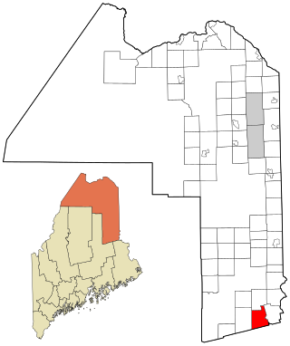
Sherman is a town in Aroostook County, Maine, United States. The population was 815 at the 2020 census.

<span class="mw-page-title-main">Westfield, Maine</span> Town in the state of Maine, United States

Westfield is a town in Aroostook County, Maine, United States. The population was 455 at the 2020 census.

Lowell is a town in Penobscot County, Maine, United States. The population was 368 at the 2020 census.

<span class="mw-page-title-main">Smithfield, Maine</span> Town in the state of Maine, United States

Smithfield is a town in Somerset County, Maine, United States. The population was 925 at the 2020 census. The town was incorporated on February 29, 1840, making it the only town in Maine incorporated on Leap Day. The town was named after the Rev. Henry Smith, an early settler.

<span class="mw-page-title-main">Carney, Michigan</span> Village in Michigan, United States

Carney is a village in Menominee County of the U.S. state of Michigan. The population was 179 as of the 2020 census. The village is within Nadeau Township.

<span class="mw-page-title-main">Mason City, Nebraska</span> Village in Nebraska, United States

Mason City is a village in Custer County, Nebraska, United States. The population was 171 at the 2010 census.

<span class="mw-page-title-main">Harwood, North Dakota</span> City in North Dakota, United States

Harwood is a city in Cass County, North Dakota, United States. The population was 794 at the 2020 census. It has become a bedroom community of the nearby Fargo-Moorhead area. Harwood was founded in 1881.

<span class="mw-page-title-main">Madisonburg, Pennsylvania</span> Census designated place in Pennsylvania, United States

Madisonburg is an unincorporated community and census-designated place (CDP) in Miles Township, Centre County, Pennsylvania, United States. It is part of the State College, Pennsylvania Metropolitan Statistical Area. The population was 168 at the 2010 census.

<span class="mw-page-title-main">Lewis Township, Union County, Pennsylvania</span> Township in Pennsylvania, United States

Lewis Township is a township in Union County, Pennsylvania, United States. The population was 1,456 at the 2020 census. Sand Bridge State Park, a Pennsylvania state park, is in Lewis Township along Pennsylvania Route 192.

<span class="mw-page-title-main">Raymond, South Dakota</span> Town in South Dakota, United States

Raymond is a rural small village in western Clark County, South Dakota, United States. The population was 53 at the 2020 census. There is a post office at Raymond, also a fire station, a church, and a bar.

<span class="mw-page-title-main">Davy, West Virginia</span> Town in West Virginia, United States

Davy is a town in McDowell County, West Virginia, United States. The population was 420 at the 2010 census. Founded in 1873, the town was originally called Hallsville but the name would change to Davy by 1901. Davy was officially incorporated in 1948. It is a mostly residential community in a coal mining district along the main line of the Norfolk Southern Railway.

<span class="mw-page-title-main">Primrose, Wisconsin</span> Town in Wisconsin, United States

The Town of Primrose is located in Dane County, Wisconsin, United States. As of 2020, the population was 750.

<span class="mw-page-title-main">Green Valley, Marathon County, Wisconsin</span> Town in Wisconsin, United States

Green Valley is a town in Marathon County, Wisconsin, United States. It is part of the Wausau, Wisconsin Metropolitan Statistical Area. The population was 541 at the 2010 census. The unincorporated community of Rangeline is located partially in the town.

<span class="mw-page-title-main">Halsey, Wisconsin</span> Town in Wisconsin, United States

Halsey is a town in Marathon County, Wisconsin, United States. It is part of the Wausau, Wisconsin Metropolitan Statistical Area. The population was 651 at the 2010 census. The town is named for Pierson Halsey, a partner in the Milwaukee law firm of Rietbrock, Halsey and Johnson, which founded Athens, Wisconsin. It was set off from the town of Hamburg in 1883.

<span class="mw-page-title-main">Warren, Waushara County, Wisconsin</span> Town in Wisconsin, United States

Warren is a town in Waushara County, Wisconsin, United States. The population was 675 at the 2000 census. The ghost town of Rodney was located partially in the town.

References

  1. 1 2 "US Board on Geographic Names". United States Geological Survey. October 25, 2007. Retrieved January 31, 2008.
  2. 1 2 "U.S. Census website". United States Census Bureau . Retrieved January 31, 2008.