Downsville, Wisconsin | |
|---|---|
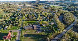 Wis-25 runs by town | |
 Downsville Location within the state of Wisconsin | |
| Coordinates: 44°46′29″N91°55′55″W / 44.77472°N 91.93194°W | |
| Country | United States |
| State | Wisconsin |
| County | Dunn |
| Town | Dunn |
| Area | |
• Total | 0.805 sq mi (2.08 km2) |
| • Land | 0.758 sq mi (1.96 km2) |
| • Water | 0.047 sq mi (0.12 km2) |
| Population | |
• Total | 188 |
| • Density | 248/sq mi (95.8/km2) |
| Time zone | UTC-6 (Central (CST)) |
| • Summer (DST) | UTC-5 (CDT) |
| Area codes | 715 & 534 |
| Census | Pop. | Note | %± |
|---|---|---|---|
| 2010 | 146 | — | |
| 2020 | 188 | 28.8% |
Downsville is an unincorporated census-designated place in the town of Dunn, located within Dunn County, Wisconsin, United States, [2] [3] where Highway 25 crosses the Red Cedar River. As of the 2020 census, its population was 188, up from 146 at the 2010 census. [4]
The community was founded in 1855. Around that time, Ebenezer Thompson tried to dam the Red Cedar, but his half-built dam was destroyed by a flood. In 1857 Captain Downs tried again and succeeded in building a dam which powered a sawmill. The village was platted in 1859, and named for Downs. He sold the mill to Knapp, Stout & Co., who expanded it and added planing and shingle mills which employed about 100 men by 1891. By that year the town also had a steam feed mill and a stop on the Menomonie branch of the Chicago, Milwaukee & St Paul Railway. [5]

