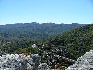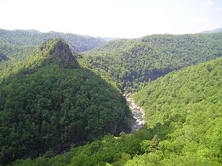
The Red River Gorge is a canyon system on the Red River in east-central Kentucky. Geologically, it is part of the Pottsville Escarpment.

Owsley County is a county located in the Eastern Coalfield region of the U.S. state of Kentucky. As of the 2010 census, the population was 4,755, making it the second-least populous county in Kentucky. The county seat is Booneville. The county was organized on January 23, 1843, from Clay, Estill, and Breathitt counties and named for William Owsley (1782–1862), the judge of the Kentucky Court of Appeals and Governor of Kentucky (1844–48).

McCreary County is a county located in the U.S. state of Kentucky. As of the 2010 census, the population was 18,306. Its county seat is Whitley City. The county is named for James B. McCreary, a Confederate war hero and two-time Governor of Kentucky. During his second term as Governor, McCreary County was created by the Legislature and was named in his honor.

Cumberland is a home rule-class city in Harlan County, Kentucky, in the United States. The population according to the 2010 Census was 2,237, down from 2,611 at the 2000 census.

Hyden is a home rule-class city in and the county seat of Leslie County, Kentucky, United States. The population was 365 at the 2010 census. It is located at the junction of U.S. Route 421 and Kentucky Route 80, along the Middle Fork of the Kentucky River.

The Cumberland River is a major waterway of the Southern United States. The 688-mile-long (1,107 km) river drains almost 18,000 square miles (47,000 km2) of southern Kentucky and north-central Tennessee. The river flows generally west from a source in the Appalachian Mountains to its confluence with the Ohio River near Paducah, Kentucky, and the mouth of the Tennessee River. Major tributaries include the Obey, Caney Fork, Stones, and Red rivers.

The Kentucky River is a tributary of the Ohio River, 260 miles (418 km) long, in the U.S. Commonwealth of Kentucky. The river and its tributaries drain much of the central region of the state, with its upper course passing through the coal-mining regions of the Cumberland Mountains, and its lower course passing through the Bluegrass region in the north central part of the state. Its watershed encompasses about 7,000 square miles (18,000 km2). It supplies drinking water to about one-sixth of the population of the Commonwealth of Kentucky.

The Cumberland Mountains are a mountain range in the southeastern section of the Appalachian Mountains. They are located in western Virginia, southwestern West Virginia, eastern edges of Kentucky, and eastern middle Tennessee, including the Crab Orchard Mountains. Their highest peak, with an elevation of 4,223 feet (1,287 m) above mean sea level, is High Knob, which is located near Norton, Virginia.

The Big South Fork of the Cumberland River is a 76-mile-long (122 km) river in the U.S. states of Tennessee and Kentucky. It is a major drainage feature of the Cumberland Plateau, a major tributary of the Cumberland River system, and the major feature of the Big South Fork National River and Recreation Area.

Rock Island is an unincorporated community in the northeastern-most portion of Warren County, Tennessee, United States. The town is named after an island on the Caney Fork River just below the confluence of the Rocky River. Rock Island is home to the Great Falls Dam and Rock Island State Park.

The Sheltowee Trace Trail is a 333-mile (535.91 km) National Recreation Trail that was created in 1979 and stretches from the Burnt Mill Bridge Trail Head in the Big South Fork National River and Recreation Area in Tennessee to northern Rowan County, Kentucky. The trail is named after Daniel Boone, who was given the name Sheltowee when he was adopted as the son of the great warrior Chief Blackfish of the Shawnee tribe.

Carr Creek Lake, located east of Hazard, Kentucky, along Kentucky Route 15 in Knott County, is a 710 acres (3 km2) reservoir created by the U.S. Army Corps of Engineers in 1976. Carr Creek Lake's earth and rock fill dam is 130 ft (40 m) tall and 720 ft (219 m) long, and the dam is located 8.8 mi (14 km) above the mouth of Carr Fork River, a tributary of the North Fork Kentucky River.

The Big South Fork National River and Recreation Area preserves the Big South Fork of the Cumberland River and its tributaries in northeastern Tennessee and southeastern Kentucky. In addition, the former mining community of Blue Heron is preserved and interpreted via signage.

Natural Bridge State Resort Park is a Kentucky state park located in Powell and Wolfe Counties along the Middle Fork of the Red River, adjacent to the Red River Gorge Geologic Area and surrounded by the Daniel Boone National Forest. Its namesake natural bridge is the centerpiece of the park. The natural sandstone arch spans 78 ft (24 m) and is 65 ft (20 m) high. The natural process of weathering formed the arch over millions of years. The park is approximately 2,300 acres (9 km2) of which approximately 1,200 acres (5 km2) is dedicated by the Office of Kentucky Nature Preserves as a nature preserve. In 1981 this land was dedicated into the nature preserves system to protect the ecological communities and rare species habitat. The first federally endangered Virginia big eared bats, Corynorhinus townsendii virginianus, recorded in Kentucky were found at Natural Bridge State Resort Park in the 1950s.

Breaks Interstate Park is a bi-state state park located partly in southeastern Kentucky and mostly in southwestern Virginia, in the Jefferson National Forest, at the northeastern terminus of Pine Mountain. Rather than their respective state park systems, it is instead administered by an interstate compact between the states of Virginia and Kentucky. It is one of several interstate parks in the United States, but only one of two operated jointly under a compact rather than as two separate state park units. The Virginia Department of Conservation and Recreation and the Kentucky Department of Parks are still major partner organizations, however.
Alasmidonta atropurpurea, common name Cumberland elktoe, is a species of freshwater mussel, an aquatic bivalve mollusk in the family Unionidae, the river mussels.

Pine Mountain is a ridge in the Appalachian Mountains running through Kentucky, Virginia and Tennessee. It extends about 125 miles from near Pioneer, Tennessee, to a location near Elkhorn City, Kentucky. Birch Knob, the highest point, is 3,273 feet above sea level and is located on the Kentucky-Virginia border. It has been a barrier to transportation as the Cumberland River at Pineville, Kentucky is one of only two streams passing through the entire ridge. The other is the Clear Fork near Jellico, Tennessee.


