
The Ozarks, also known as the Ozark Mountains, Ozark Highlands or Ozark Plateau, is a physiographic region in the U.S. states of Missouri, Arkansas, Oklahoma, and only ~55 square miles in the southeastern corner of Kansas. The Ozarks cover a significant portion of northern Arkansas and most of the southern half of Missouri, extending from Interstate 40 in central Arkansas to Interstate 70 in central Missouri.

The White River is a 722-mile (1,162 km) river that flows through the U.S. states of Arkansas and Missouri. Originating in the Boston Mountains of northwest Arkansas, it arcs northwards through southern Missouri before turning back into Arkansas, flowing southeast to its mouth at the Mississippi River.

The Spring River is a 57-mile (92 km) long river which flows through the U.S. states of Missouri and Arkansas. It consists of two branches, the South Fork of the Spring River and the Spring River proper. The South Fork of the Spring River starts in Howell County, Missouri and flows south through Fulton and Sharp counties in Arkansas. The South Fork of the Spring River joins the Spring River proper near the town of Hardy, Arkansas. The South Fork is a quiet stream with gravelly bars that are ideal for camping.

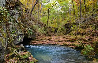
The Current River forms in the southeastern portion of the Ozarks of Missouri and becomes a 7th order stream as it flows southeasterly out of the Ozarks into northeastern Arkansas where it becomes a tributary of the Black River, which is a tributary of the White River, a tributary of the Mississippi River. The Current River is approximately 184 miles (296 km) long and drains about 2,641 square miles (6,840 km2) of land mostly in Missouri and a small portion of land in northeastern Arkansas. The headwaters of the Current River are nearly 900 feet (270 m) above sea level, while the mouth of the river lies around 280 feet (85 m) above sea level. The basin drains a rural area that is dominated by karst topography, underlain by dolomite and sandstone bedrock with a small area of igneous rock southeast of Eminence, Missouri. The annual daily mean discharge of the river near Doniphan, Missouri is 2,815 cubic feet (79.7 m3) per second. In 1964, over 134 mi (160 km) of the upper course of the river and its tributaries were federally protected as the Ozark National Scenic Riverways, the first national park in America to protect a river system.

Oatka Creek is the third longest tributary of the Genesee River, located entirely in the Western New York region of the U.S. state of New York. From southern Wyoming County, it flows 58 miles (93 km) to the Genesee near Scottsville, draining an area of 215 square miles (560 km2) that includes all or part of 23 towns and villages in Wyoming, Genesee, Livingston and Monroe counties as well. Its name means "leaving the highlands" or "approaching an opening" in Seneca.

The Big River is a tributary of the Meramec River in east-central Missouri. The river rises in western Iron County near the summit of Johnson Mountain just north of Missouri Route 32 and approximately 3.5 miles southeast of the community of Enough. It flows through Washington, Saint Francois, and Jefferson counties. It forms part of the boundary between Jefferson and Saint Francois counties and also part of the boundary between Jefferson and Washington counties. It empties into the Meramec River opposite Eureka where the Meramec forms the border between Jefferson and Saint Louis counties. The river flows through Washington State Park, St. Francois State Park, and the Lead Belt mining district. The elevation of the river at its source is approximately 1,300 feet (400 m) above sea level and at its mouth about 400 feet (120 m). The length of the river is approximately 145 miles (233 km), while the airline distance between source and mouth is about 56 miles (90 km). Its watershed area is 955 square miles (2,470 km2).

Maramec Spring is located on the Meramec River near St. James in the east-central Ozarks of Missouri. The fifth largest spring in the state with an average discharge of 153 cubic feet (4.3 m3) of water per second, it is part of a Karst topographical area, with many springs and caves. The spring and 1800 acres (7.28 km²) are owned by the James Foundation, which maintains the area as a public park, donated by Lucy Wortham James. The Missouri Department of Conservation operates a trout hatchery and fishery at the spring. Ruins of the Maramec Iron Works are still visible at the site; its machinery was partly powered by the spring's waterflow. The spring was declared a National Natural Landmark in October 1971.

Zanoni is an unincorporated community located in Ozark County, Missouri, United States on Route 181, approximately ten miles northeast of Gainesville. A watermill and a post office are all that remain of the community. The community was founded in 1898 and was named for the novel Zanoni by Edward Bulwer-Lytton. The mill was built in 1905 as an overshot wheel mill by "Doc" Morrison and restored by his grandson.
Almartha is an unincorporated community in northern Ozark County, Missouri, United States. It is located approximately thirteen miles north of Gainesville and four miles southeast of Wasola on Route 95. The village is located in a valley on a tributary of Spring Creek. Several homes are located there. The old mill and current fish hatchery of Rockbridge lies downstream on Spring Creek, about six miles to the east.

Harveys Creek is a tributary of the Susquehanna River in Luzerne County, Pennsylvania, in the United States. It is approximately 14.5 miles (23.3 km) long and flows through Harveys Lake, Lake Township, Lehman Township, Jackson Township, and Plymouth Township. The creek's watershed has an area of 46.3 square miles (120 km2). The creek has four named tributaries, which are known as Bear Hollow Creek, Paint Spring Run, Pikes Creek, and East Fork Harveys Creek. The watershed is designated as a High-Quality Coldwater Fishery and a Migratory Fishery above Pikes Creek and as a Coldwater Fishery and a Migratory Fishery below it. The creek's source is Harveys Lake, the largest natural lake in Pennsylvania.

Big Wapwallopen Creek is a tributary of the Susquehanna River in Luzerne County, Pennsylvania, in the United States. It is approximately 23 miles (37 km) long and flows through Bear Creek Township, Fairview Township, Rice Township, Wright Township, Dorrance Township, Hollenback Township, Nescopeck Township, and Conyngham Township. The watershed of the creek has an area of 53.2 square miles (138 km2). The creek has three named tributaries: Balliet Run, Watering Run, and Bow Creek. The creek is designated as a Coldwater Fishery and a Migratory Fishery and is also Class A Wild Trout Waters for part of its length. However, a portion is considered to be impaired by organic enrichment and/or low levels of dissolved oxygen and its pH ranges from moderately acidic to slightly alkaline.

The North Fork River or the North Fork of White River is a 109-mile-long (175 km) tributary of the White River, into which it flows near Norfork, Arkansas.
Greer Spring is a first magnitude spring located in the southeast portion of the Ozark Plateau, in Oregon County in south-central Missouri within the boundaries of the Mark Twain National Forest. The spring is the second largest spring in the Ozarks, with an average discharge of 360 cubic feet (10 m3) of water per second. Greer Spring was designated a National Natural Landmark in 1980.
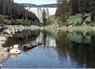
The North Fork Clearwater River is a major tributary of the Clearwater River in the U.S. state of Idaho. From its headwaters in the Bitterroot Mountains of eastern Idaho, it flows 135 miles (217 km) westward and is dammed by the Dworshak Dam just above its mouth in north-central Idaho. Draining a rugged watershed of 2,462 square miles (6,380 km2), the river has an average flow of over 5,600 cubic feet per second (160 m3/s), accounting for a third of the discharge from the Clearwater basin. The river drains parts of Clearwater, Shoshone, Latah, and Idaho counties. Most of the watershed is managed by the U.S. Forest Service. Some of the fish of the river include westslope cutthroat trout, rainbow trout, mountain whitefish, and the threatened bull trout. It also has smallmouth bass and a kokanee salmon run, both from Dworshak Reservoir. The North Fork drainage is home to grizzly bears, cougars, deer, moose, black bear, elk, grey wolves, and osprey. The river used to have a large steelhead run before the implementation of Dworshak Dam. The North Fork of the Clearwater is located within the Clearwater National Forest

Big Butte Creek is a 12-mile-long (19 km) tributary of the Rogue River in the U.S. state of Oregon. It drains approximately 245 square miles (635 km2) of Jackson County. Its two forks, the North Fork and the South Fork, both begin high in the Cascade Range near Mount McLoughlin. Flowing predominantly west, they meet near the city of Butte Falls. The main stem flows generally northwest until it empties into the Rogue Falls was incorporated in 1911, and remains the only incorporated town within the watershed's boundaries.

Vera Cruz is an unincorporated community in central Douglas County, Missouri, United States. It is located on Bryant Creek, approximately 9 miles (14 km) east of Ava, at the terminus of Route AB.

Dogwood is an unincorporated community in northwestern Douglas County, Missouri, United States. It is located on Missouri Route 14, approximately 15.5 miles (24.9 km) northwest of Ava and 8.5 miles (13.7 km) southwest of Seymour. The old store building sits at the intersection of Route 14 with route BB and the Dogwood cemetery is 1,300 feet (400 m) to the west at the intersection of routes 14 and Z.
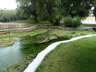
Big Spring Creek is a tributary of the Judith River in Fergus County, Montana near Lewistown, Montana. The creek originates from a first magnitude artesian spring approximately 6 miles (9.7 km) south of Lewistown and flows north, northwest for 30 miles (48 km) to its confluence with the Judith River. The spring is one of the largest in the world flowing at approximately 50,000 to 64,000 US gallons per minute out of the Madison-Limestone formation in the foothills of the Big Snowy Mountains. The creek flows through and under the town of Lewistown. For three blocks spanning Main Street, the creek runs underneath the town in a man-made channel that was created as the town was built over the creek. The spring provides Lewistown's water supply, which requires no treatment for use by consumers.
North Branch Mehoopany Creek is a tributary of Mehoopany Creek in Bradford County, Sullivan County, and Wyoming County, in Pennsylvania, in the United States. It is approximately 14 miles (23 km) long and flows through Wilmot Township in Bradford County, Colley Township in Sullivan County, and North Branch Township and Forkston Township. The watershed of the creek has an area of 40.0 square miles (104 km2). The creek has eight named direct tributaries, including hollows. In the 1940s and 1950s, the average discharge for September was found to be just 6.8 cubic feet per second (0.19 m3/s), but was found to be over 100 cubic feet per second (2.8 m3/s) for July and August.

Thomes Creek is a major watercourse on the west side of the Sacramento Valley in Northern California. The creek originates in the Coast Ranges and flows east for about 62 miles (100 km) to join the Sacramento River, at a point about 7 miles (11 km) northeast of Corning in Tehama County.


