
Franklin County is located in the Blue Ridge foothills of the U.S. state of Virginia. As of the 2010 census, the population was 56,159. Its county seat is Rocky Mount.
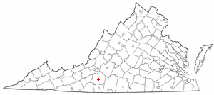
Rocky Mount is a town in and the county seat of Franklin County, Virginia, United States. The town is part of the Roanoke Metropolitan Statistical Area, and had a population of 4,799 as of the 2010 census. It is located in the Roanoke Region of Virginia.
Rocky Ford or Rockyford may refer to:

The Roanoke Metropolitan Statistical Area is a Metropolitan Statistical Area (MSA) in Virginia as defined by the United States Office of Management and Budget (OMB). The Roanoke MSA is sometimes referred to as the Roanoke Valley, even though the Roanoke MSA occupies a larger area than the Roanoke Valley. It is geographically similar to the area known as the Roanoke Region of Virginia, but while the latter includes Alleghany County, the former does not. As of the 2000 census, the MSA had a population of 288,309.

Rio is an unincorporated community in southern Hampshire County in the U.S. state of West Virginia. Rio is located just north of the Hardy County line at the crossroads of Augusta-Ford Hill Road and Delray Road in the North River Valley. According to the 2000 census, the Rio community has a population of 154.

West Virginia Route 28 is a north–south route through the Potomac Highlands of the U.S. state of West Virginia. The southern terminus of the route is at West Virginia Route 39 in Huntersville. The northern terminus is at the Maryland state line in Wiley Ford, where the route continues into Cumberland as Canal Parkway upon crossing the North Branch Potomac River.
Back Creek is a 59.5-mile-long (95.8 km) tributary of the Potomac River that flows north from Frederick County, Virginia, to Berkeley County in West Virginia's Eastern Panhandle. Back Creek originates along Frederick County's border with Hampshire County, West Virginia, at Farmer's Gap in the Great North Mountain. Its name reflects its location to the west of North Mountain. The perspective of colonists from the east in the 18th century led them to call it "Back Creek", because it lay to the back of North Mountain.
Davis Ford is an unincorporated community on the Cacapon River in Hampshire County in the U.S. state of West Virginia. It lies primarily on Cacapon River Road at the ford from which it takes its name. The Yellow Spring post office serves the Davis Ford community.

State Route 61 is a primary state highway in the U.S. state of Virginia. The state highway runs 48.16 miles (77.51 km) from SR 16 in Tazewell east to U.S. Route 460 in Narrows. SR 61 passes through several narrow creek valleys as it parallels the West Virginia state line through Tazewell, Bland, and Giles counties. The only sizeable community between the highway's endpoints is Rocky Gap, where the highway meets US 52 and Interstate 77 (I-77).
The 5th West Virginia Infantry Regiment was an infantry regiment that served in the Union Army during the American Civil War.
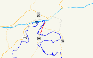
Canal Parkway, which carries the unsigned Maryland Route 61 designation, is a state highway and automobile parkway in the U.S. state of Maryland. The road begins at the West Virginia state line at the North Branch Potomac River opposite Wiley Ford, where the highway continues south as West Virginia Route 28. The parkway runs 1.94 miles (3.12 km) north to MD 51 within the city of Cumberland. Canal Parkway provides a connection between downtown Cumberland and the South Cumberland neighborhood and with Greater Cumberland Regional Airport, which is located in Mineral County, West Virginia.

Riding with Buffalo Bill is a 1954 American Western Serial film directed by Spencer Gordon Bennet and starring Marshall Reed.
Lewis Thornton Babcock is a Senior United States District Judge of the United States District Court for the District of Colorado and former judge of the Colorado Court of Appeals.

A ford is a shallow place with good footing where a river or stream may be crossed by wading, or inside a vehicle getting its wheels wet. A ford may occur naturally or be constructed. Fords may be impassable during high water. A low water crossing is a low bridge that allows crossing over a river or stream when water is low but may be covered by deep water when the river is high.
Jarretts Ford is an unincorporated community in Kanawha County, West Virginia.
Rocky Fork is an unincorporated community in Kanawha County, West Virginia.

The 1976 United States presidential election in West Virginia was held on November 2, 1976 as part of the 1976 United States presidential election. The two major party candidates, Republican Gerald Ford and Democrat Jimmy Carter were the only candidates to appear on the state's ballot. Carter won the state of West Virginia with 58% of the vote, carrying the state's 6 electoral votes. He had a 16.14 point margin over the incumbent President Ford. As of the 2020 presidential election, this is the last election in which Putnam County, Mineral County, and Hampshire County voted for the Democratic candidate.
George Michael Ford was an American football player and coach and education administrator.


