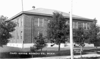
Roseau County is a county in the northwestern part of the U.S. state of Minnesota, along the Canada–US border. As of the 2020 census, the population was 15,331. Its county seat is Roseau. Roseau County borders the Canadian province of Manitoba.
Deer Township is a township in Roseau County, Minnesota, United States. The population was 92 at the 2000 census.
Dieter Township is a township in Roseau County, Minnesota, United States located along the Canada–US border. The population was 162 at the 2000 census. Dieter Township contains the unincorporated communities of Pinecreek and Ross.
Grimstad Township is a township in Roseau County, Minnesota, United States. The population was 190 at the 2000 census.
Palmville Township is a township in Roseau County, Minnesota, United States. The population was 55 at the 2000 census. The town was named for Louis Palm, a Swedish settler.

Roseau is a city in, and the county seat of, Roseau County, Minnesota. Its population was 2,744 at the time of the 2020 census.
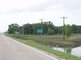
Ross Township is a township in Roseau County, Minnesota, United States. The population was 454 at the 2000 census.

Piney Pinecreek Border Airport is a public use general aviation airport located 2 nautical miles northwest of the central business district of Pinecreek, in Dieter Township, Roseau County, Minnesota, United States, on the Canada–US border. It is jointly owned by the Minnesota Department of Transportation and the government of Piney, Manitoba. It is shared by the rural communities of Piney, Manitoba and Pinecreek, Minnesota.

Minnesota State Highway 89 (MN 89) is a 143.650-mile-long (231.182 km) highway in northwest Minnesota, which runs from its intersection with U.S. Highway 2 at Eckles Township, just north of Wilton and continues north to its northern terminus at the Canadian border, where it becomes Manitoba Highway 89, near Pinecreek.
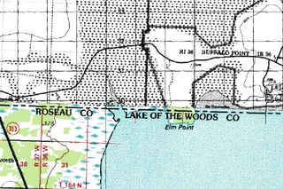
Elm Point, Minnesota, is a small uninhabited cape and a practical exclave of the United States in Lake Township, Roseau County, Minnesota, United States. It is surrounded on the west, south, and east by Lake of the Woods, and on the north by the Canadian First Nation community of Buffalo Point in southeastern Manitoba. Part of Elm Point is privately owned and part of it is state land managed by the Department of Natural Resources as part of the Border Wildlife Management Area. It is located southwest of the much larger exclave known as the Northwest Angle. There is a line of felled trees marking the international border, which runs nominally along the 49th parallel, although in this area it runs slightly to the south due to 19th-century surveying errors.

Minnesota State Highway 308 (MN 308) is a short 1.277-mile-long (2.055 km) highway in northwest Minnesota, which runs from its intersection with State Highway 11 in Ross Township ; and continues northbound for 1.3 mile to its northern terminus at its intersection with State Highway 89 in Ross Township. Highway 89 continues north to the Canada–United States border.
Fox is an unincorporated community in Ross Township, Roseau County, Minnesota, United States.
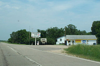
Salol is an unincorporated community in Enstrom Township, Roseau County, Minnesota, United States.
Swift is an unincorporated community in Roseau County, Minnesota, United States.
Winner is an abandoned townsite in the former Elkwood Township in southeastern Roseau County, Minnesota, United States.
Pinecreek is an unincorporated community in Dieter Township, Roseau County, Minnesota, United States, near the Canada–US border. The community is located northwest of Roseau at the junction of State Highway 89 and Roseau County Road 3.
Wannaska is an unincorporated community in Roseau County, Minnesota, United States.
Caribou is an unincorporated community in Caribou Township, Kittson County, Minnesota, United States.
Pencer is an unincorporated community in Mickinock Township, Roseau County, Minnesota, United States.
Skime is an unincorporated community in Reine Township, Roseau County, Minnesota, United States.


