Rosthwaite, Borrowdale

Last updated

Rosthwaite
Borrowdale - Rosthwaite.jpg
Rosthwaite
Location map United Kingdom Cumberland 1960.svg
Red pog.svg
Rosthwaite
Location in Cumberland, Cumbria
Cumbria UK location map.svg
Red pog.svg
Rosthwaite
Location within Cumbria
OS grid reference NY257148
Civil parish
Unitary authority
Ceremonial county
Region
Country England
Sovereign state United Kingdom
Post town KESWICK
Postcode district CA12
Dialling code 017687
Police Cumbria
Fire Cumbria
Ambulance North West
UK Parliament
List of places
UK
England
Cumbria
54°31′25″N3°08′49″W / 54.523522°N 3.146982°W / 54.523522; -3.146982

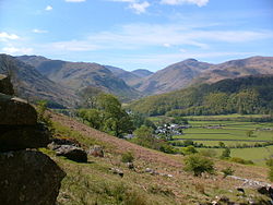
Rosthwaite is a settlement in the Borrowdale parish of Cumberland, Cumbria, England. It is also in Borrowdale in the English Lake District to the south of Derwent Water. The B5289 road goes through the settlement and it is to the east of the Honister Pass.

Contents

Historically part of Cumberland, the nearest town to Rosthwaite is Keswick, which is situated approximately 6 miles (9.7 km) to the north.

Geographical features

Rosthwaite is host to many interesting post-glacial geographical features. The town nestles underneath the How, a large roche moutonnée, with a smaller roche moutonnée being further to the west.

Near to and within Rosthwaite is also a set of terminal moraines which show the staggered retreat of the Stonethwaite Glacier. These are quite obvious, with the middle and best preserved moraine being found NY 258145.

Governance

Rosthwaite is within the Penrith and Solway UK Parliamentary constituency.

For Local Government purposes it is in the Keswick Ward of Cumberland Council.

Rosthwaite is parished; Borrowdale Parish Council. [1]

See also

Related Research Articles

<span class="mw-page-title-main">Derwentwater</span> Lake in the Lake District, Cumbria, England

Derwentwater, or Derwent Water, is a lake in the Lake District in North West England, immediately south of Keswick. It is in the unitary authority of Cumberland within the ceremonial county of Cumbria. It is the third largest lake by area, after Windermere and Ullswater. It has a length of 4.6 kilometres (2.9 mi), a maximum width of 1.91 kilometres (1.19 mi), and an area of 5.4 square kilometres (2.1 sq mi). Its primary inflow and outflow is the River Derwent, which also flows through Bassenthwaite Lake before reaching the Irish Sea at Workington. There are several islands within the lake, one of which is inhabited. Derwentwater is a place of considerable scenic value. It is surrounded by hills, and many of the slopes facing Derwentwater are extensively wooded. A regular passenger launch operates on the lake, taking passengers between various landing stages. There are seven lakeside marinas, the most popular stops being Keswick, Portinscale and the Lodore Falls, from which boats may be hired. Recreational walking is a major tourist activity in the area and there is an extensive network of footpaths in the hills and woods surrounding the lake.

<span class="mw-page-title-main">Cumberland</span> Historic county of England

Cumberland is an area of North West England which was historically a county. The county was bordered by Northumberland to the north-east, County Durham to the east, Westmorland to the south-east, Lancashire to the south, and the Scottish counties of Dumfriesshire and Roxburghshire to the north. The area includes the city of Carlisle, part of the Lake District and North Pennines, and the Solway Firth coastline.

<span class="mw-page-title-main">Keswick, Cumbria</span> Town and Civil Parish in Cumbria, England

Keswick is a market town and civil parish in the Cumberland unitary authority area of Cumbria, England. Historically, until 1974, it was part of the county of Cumberland. It lies within the Lake District National Park, just north of Derwentwater and four miles from Bassenthwaite Lake. The parish had a population of 5,243 at the 2011 census.

<span class="mw-page-title-main">Allerdale</span> Former non-metropolitan district in England

Allerdale was a non-metropolitan district of Cumbria, England, with borough status. Its council – Allerdale Borough Council – was based in Workington, and the borough had a population of 96,422 at the 2011 census.

<span class="mw-page-title-main">Cumbria Way</span> Long-distance footpath in Cumbria, England

The Cumbria Way is a linear 112-kilometre (70-mile) long-distance footpath in Cumbria, England. The majority of the route is inside the boundaries of the Lake District National Park. Linking the two historic Cumbrian towns of Ulverston and Carlisle, it passes through the towns of Coniston and Keswick. The route cuts through Lakeland country via Coniston Water, Langdale, Borrowdale, Derwent Water, Skiddaw Forest and Caldbeck. It is a primarily low-level route with some high-level exposed sections.

<span class="mw-page-title-main">Borrowdale</span> Valley and civil parish in Cumbria, England

Borrowdale is a valley and civil parish in the English Lake District in Cumberland, England. It is in the ceremonial county of Cumbria, and is sometimes referred to as Cumberland Borrowdale to distinguish it from another Borrowdale in the historic county of Westmorland.

<span class="mw-page-title-main">Stonethwaite</span> Human settlement in England

Stonethwaite is a small village in the Lake District in the English county of Cumbria, historically part of Cumberland, it is situated in the valley of the Stonethwaite Beck, a side valley of Borrowdale, and within the Lake District National Park. It is on the Cumbria Way long-distance footpath.

<span class="mw-page-title-main">B5289 road</span> Road in the Lake District, England

The B5289 is a road in the Lake District, England. It lies in the county of Cumbria, and is an important traffic artery in the Lake District.

<span class="mw-page-title-main">Greysouthen</span> Village in Cumbria, England

Greysouthen is a village and civil parish between the towns of Workington and Cockermouth, in Cumbria, North West England, historically part of Cumberland, near the Lake District National Park. The village has an historic association with coal mining.

<span class="mw-page-title-main">Bothel, Cumbria</span> Human settlement in England

Bothel is a small village in Cumbria, England. Bothel was historically within Cumberland.

<span class="mw-page-title-main">High Spy</span> Mountain in the English Lake District, Cumbria, England

High Spy is a fell in the English Lake District it is situated on the ridge that separates the Newlands Valley from Borrowdale, eight kilometres south of Keswick.

<span class="mw-page-title-main">Rosthwaite Fell</span>

Rosthwaite Fell is a fell in the English Lake District. It is situated some 12 kilometres due south of Keswick and 2 kilometres south of the village of Rosthwaite in Borrowdale.

<span class="mw-page-title-main">Seathwaite, Cumberland</span> Hamlet in Cumbria, England

Seathwaite is a small hamlet in the Borrowdale civil parish of Cumberland, Cumbria, North West England. It is in the Lake District near Scafell Pike and 8 miles (13 km) southwest of Keswick at the end of a minor road that heads southwest from the hamlet of Seatoller, which is where the B5289 road begins its steep climb up the pass to Honister Hause on the boundary between Borrowdale civil parish and Buttermere civil parish.

<span class="mw-page-title-main">Buttermere, Cumbria (village)</span> Village and civil parish in England

Buttermere is a village and civil parish in the county of Cumbria, England.

Rosthwaite, Cumbria may refer to two different settlements in the English county of Cumbria:

<span class="mw-page-title-main">Grange in Borrowdale</span> Human settlement in England

Grange, often called Grange in Borrowdale, is a village in Borrowdale in the English Lake District. It lies just off the B5289 road to the south of Derwent Water and 4 miles (6.4 km) south of Keswick, in the county of Cumbria, historically part of Cumberland,

<span class="mw-page-title-main">Seatoller</span> Hamlet in Cumbria, England

Seatoller is a settlement in Borrowdale in the English Lake District. Historically part of Cumberland, it lies on the B5289 road at the east foot of the Honister Pass, and to the south of Derwent Water. The nearest town to Seatoller is Keswick, which is situated approximately 7 miles (11 km) to the north.

<span class="mw-page-title-main">Sunderland, Cumbria</span> Human settlement in England

Sunderland is a hamlet and former civil parish, within the Lake District National Park, now in the parish of Blindcrake in the Cumberland unitary authority district of the county of Cumbria, England, historically part of Cumberland. In 1931 the parish had a population of 60.

Rosthwaite may refer to:

References

  1. "Borrowdale Parish Council".