The Wakefield line is a railway line and service in the West Yorkshire Metro and South Yorkshire Passenger Transport Executive areas of northern England. The Wakefield line is coloured yellow on maps and publications by West Yorkshire Metro. The line was electrified in 1989, between Leeds & Wakefield Westgate, as part of the programme to electrify the East Coast Main Line.

Parkgate is a suburb of Rotherham, South Yorkshire, England. It has since been consumed by its neighbour, Rawmarsh and is in the ward of Rawmarsh from which it has been indistinguishable since the early 20th century.
Parkgate and Aldwarke railway station was a railway station situated in Parkgate a district of Rotherham, South Yorkshire, England on the Manchester, Sheffield and Lincolnshire Railway company's line between Rotherham Road and Kilnhurst Central. The station, opened in July 1873, was originally known as "Aldwarke", taking its name from the local manor house nearby which it served along with 8 or 9 servants cottages and a small farmstead. The principal reason for the building of the station, however, was its close proximity to two local collieries, Aldwarke Main and Roundwood. The stopping passenger service fitted in with the requirements of the shift workers at collieries and with many workers living in Rotherham it was recorded that over 100 men would arrive at the station for the early shift alone.
Rotherham Road railway station, named Park Gate until 1 November 1895, was a railway station situated in Rotherham, South Yorkshire, England. It was built close to the Rotherham borough boundary with access from Rawmarsh Road, Rotherham and served two rows of stone build terraced houses, "Parkgate Row", closest to the station and "Stone Row", actually on Rotherham Road, Parkgate.
Earl Fitzwilliam's private railway near Rotherham, South Yorkshire, was constructed in order to link the Earl's coal interests to the southeast of his Wentworth estate with the Greasbrough Canal, also owned by his estate, which gave an outlet to the River Dun (Don) Navigation.
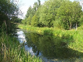
The Greasbrough Canal was a private canal built by the Marquess of Rockingham to serve his coal mining interests in and around the village of Greasbrough, near Rotherham, South Yorkshire, England. It opened in 1780, and the Newbiggin branch was built some time later. The main line to Greasbrough closed in 1840 with the coming of the Sheffield and Rotherham Railway, and the canal ceased to carry commercial traffic during the First World War. Most of it has been filled in, but a small section near the River Don Navigation remains in water.
The Park Gate Iron and Steel Company was a British company that smelted iron ore and turned it into rolled steel and semi-finished casting products. Its works was at Parkgate, South Yorkshire on a triangular site bounded on two sides by the main road between Rotherham and Barnsley (A633) and the North Midland Railway main line between Rotherham Masborough and Cudworth. It also operated ironstone quarries in Northamptonshire and Leicestershire.
The Great Central and Midland Joint Railway, formerly, before 1897, Sheffield and Midland Railway Companies' Committee, was a collection of joint railways, mainly in the Manchester and South Yorkshire areas.
John Brown's railway was a line constructed in the Rotherham area of South Yorkshire, England, in order to link Silverwood Colliery to staithes situated alongside the River Don. The line, along with the collieries, became the sole property of John Brown & Company of Sheffield, in 1910, giving the line its local name.
Silverwood Colliery was a colliery situated between Thrybergh and Ravenfield in Yorkshire, England. Originally called Dalton Main, it was renamed after a local woodland. It was owned by Dalton Main Collieries Ltd.

The Maltby Main Colliery was a coal mine located 7 miles (11 km) east of Rotherham on the eastern edge of Maltby, South Yorkshire, England. The mine was closed in 2013.
New Stubbin Colliery was a coal mine situated in the township of Rawmarsh near Rotherham, South Yorkshire, England. The colliery was situated in a deep valley. Along one side at the top of the valley runs Haugh Road, Rawmarsh and on the other a lane known locally as “Greasbrough Tops”.
Kilnhurst Colliery, formerly known as either Thrybergh or Thrybergh Hall Colliery, was situated on the southern side of the village of Kilnhurst, near Rotherham, South Yorkshire, England.
Warren House Colliery was a coal mine situated to the north of Rawmarsh, near Rotherham, South Yorkshire, England.
Warren Vale Colliery was a coal mine, also known as Piccadilly Colliery, situated alongside Warren Vale Road, between Rawmarsh and Swinton, South Yorkshire, England, in the valley of the Collier Brook, which runs east, for about two miles towards Kilnhurst.
The Dalton Main Collieries Limited became a public company which appeared on the London Stock Exchange in December 1899. The company was set up by John Brown and Company with the aim of purchasing Roundwood Colliery at Parkgate and to purchase land between Thrybergh and Ravenfield, known as Silverwood, and sink a new deep colliery there. By the time production was in full swing at Silverwood in 1909 John Brown were sole proprietors of the Dalton Main Company.
The South Yorkshire Coalfield is so named from its position within Yorkshire. It covers most of South Yorkshire, West Yorkshire and a small part of North Yorkshire. The exposed coalfield outcrops in the Pennine foothills and dips under Permian rocks in the east. Its most famous coal seam is the Barnsley Bed. Coal has been mined from shallow seams and outcrops since medieval times and possibly earlier.
Aldwarke Main Colliery was a coal mine sunk in the Don Valley, near Rotherham, South Yorkshire, England.

Rawmarsh is a large village in the Metropolitan Borough of Rotherham, in South Yorkshire, England. Historically within the West Riding of Yorkshire, it is 2 miles (3 km) north-northeast from Rotherham town centre and 3 miles (5 km) south-southwest of Swinton. The village also forms part of the Sheffield Urban Area. The Rawmarsh ward of Rotherham MBC had a population of 13,389 at the 2011 Census. Rawmarsh also contains other output areas from neighbouring wards giving it a population of 18,498 in 2011 and 18,535 in 2014.
Aldwarke Junction at Parkgate near Rotherham, South Yorkshire, England is a major railway junction. It was constructed in 1965 as a part of the Sheffield district rail rationalisation plan.
