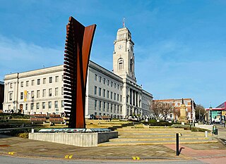
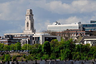
Smithies, South Yorkshire

Last updated

Smithies
Smithies Wesleyan Reform Church, Wakefield Road, Smithies - geograph.org.uk - 329876.jpg
Wesleyan Reform Church, Wakefield Road
South Yorkshire UK location map.svg
Red pog.svg
Smithies
Location within South Yorkshire
OS grid reference SK3508
Metropolitan borough
Metropolitan county
Region
Country England
Sovereign state United Kingdom
Post town BARNSLEY
Postcode district S71
Dialling code 01226
Police South Yorkshire
Fire South Yorkshire
Ambulance Yorkshire
UK Parliament
List of places
UK
England
Yorkshire
53°34′10″N1°28′20″W / 53.5694°N 1.4723°W / 53.5694; -1.4723 Coordinates: 53°34′10″N1°28′20″W / 53.5694°N 1.4723°W / 53.5694; -1.4723

Smithies is an area of Barnsley in South Yorkshire, England. It lies about two miles north-east of the town centre.

Contents

Smithies was historically a village in the township of Monk Bretton in the parish of Royston in the West Riding of Yorkshire, on the border with the township of Carlton. [1] Monk Bretton became a separate civil parish in 1866, and in 1921 was absorbed into the County Borough of Barnsley. In 1974 the county borough was abolished, and Smithies became part of the Metropolitan Borough of Barnsley in the new county of South Yorkshire.

Coal mining

A number of collieries were worked in Smithies between 1856 and 1929. East Gawber Hall Colliery, located to the north of the village, opened in 1856 and was worked until the First World War. The remains of the colliery's Guibal fanhouse, built around 1875, are listed as a historic monument. [2]

The Wallsend Main Colliery was sunk before 1901. [3] and was worked with the adjacent Primrose Main Colliery, [4] which was working before 1891. [5] [6] The Wallsend Main Colliery Company was wound up in January 1921. [7]

The Central Silkstone Colliery was sunk in 1907. [8] It was purchased by the East Barnsley Colliery Company (based in Smithies) around 1919, [9] [10] and continued in use until at least 1924.

Wharncliffe Carlton Colliery on the south edge of Smithies was notorious for an explosion in October 1883 that killed 20 miners. [11] While the inquest was being held about the initial explosion, a second underground blast severely injured two more men. [12] The colliery was connected underground with East Gawber Hall, and after the disaster, Wharncliffe Carlton was sealed off from East Gawber Hall and flooded to quench the underground fires, before it could be re-opened. [13]

By 1929, all of the collieries had closed and been demolished. [14]

Facilities

Smithies is home to a Tesco express shop, a bakery, Fish and Chip Shop, Unisex Salon, Local Shop, KFC (on the border), and has a 2005 Harron Homes housing estate, split between here and Monk Bretton.

Smithies is connected to Barnsley Interchange 7 days a week by the number 12 bus service, which operates every 15 minutes Monday-Saturday and every 30 minutes on Sundays. Monday to Saturday, bus 34 and 34a run hourly and are both loop buses, alike no.12, operating via Monk Bretton, Cudworth and Shafton. 34 operates the loop in the direction of Barnsley to Shafton via here and 34a operates via Monk Bretton and Shafton first, before entering Smithies and returning to town.

The 34 and 34a bus services stopped operating for several weeks after Tates Travel went into liquidation, this route was soon taken over by Stagecoach, the only bus operator serving Smithies (except school bus routes).

Smithies has two schools, Springwell Community School, catering for this with special needs. Alongside Holy Trinity Catholic and Church of England School which has both a primary and secondary school in one. Holy Trinity is served by a bus service to Grimethorpe operated by Waterstones and several coach companies operate services to Royston, Cudworth and Baurgh Green.

Related Research Articles

Barnsley Town in South Yorkshire, England

Barnsley is a large market town in South Yorkshire, England. It is the main settlement in the Metropolitan Borough of Barnsley. At the 2011 Census, Barnsley had a population of 91,297 out of close to 250,000 in the wider borough in the Dearne Valley. Historically in the West Riding of Yorkshire. It is located between the cities of Sheffield, Manchester, Wakefield and Leeds.

Grimethorpe Village in South Yorkshire, England

Grimethorpe is a large village in the metropolitan borough of Barnsley in South Yorkshire, England. Historically within the West Riding of Yorkshire, it had a population of 4,672 at the 2011 census. Grimethorpe is located to the east of Barnsley and south of Hemsworth; until the local government reorganisation of 1974, it was part of the Hemsworth district and constituency. At the 2011 Census the village was part of the North East ward of Barnsley MBC.

Metropolitan Borough of Barnsley Metropolitan borough in England

The Metropolitan Borough of Barnsley is a metropolitan borough of South Yorkshire, England; its main town is Barnsley.

Shafton Village and civil parish in South Yorkshire, England

Shafton is a civil parish in the Metropolitan Borough of Barnsley in South Yorkshire, England, on the border with West Yorkshire. At the 2001 census it had a population of 2,840, increasing to 3,447 at the 2011 Census. The parish contains the villages of Shafton and Shafton Two Gates.

Royston, South Yorkshire Village in South Yorkshire, England

Royston is a suburban village within the Metropolitan borough of Barnsley, in South Yorkshire, England. Historically part of the West Riding of Yorkshire, but was incorporated into the Metropolitan borough of Barnsley in 1974 and is now on the border with West Yorkshire. It is part of the Barnsley Central borough constituency, and has a population of 9,375, increasing to 10,728 at the 2011 Census. It is situated 4 miles (6.4 km) north-east of Barnsley, and 6 miles (9.7 km) south-east of Wakefield.

Athersley Village in South Yorkshire, England

Athersley is a village in the metropolitan borough of Barnsley, South Yorkshire, England.

Carlton, South Yorkshire Village in South Yorkshire, England

Carlton is a village in the Metropolitan Borough of Barnsley in South Yorkshire, England. It is situated between the villages of Athersley and Royston. The village is split in two with one half in the Monk Bretton ward and the rest in the Royston ward of the Barnsley MBC. It was built up on coking and coal mining industries and now has one of the largest industrial estates within the surrounding area. In the industrial estate lies a glass recycling plant, called Rexam. To its east stands the Mr Kipling cake factory, owned by Premier Foods.

Lundwood Village in South Yorkshire, England

Lundwood is a village in Barnsley in South Yorkshire, England.

Cudworth, South Yorkshire Village in South Yorkshire, England

Cudworth is an urban village approximately 3.5 miles (5.6 km) north-east of Barnsley transport interchange in South Yorkshire, England. Historically within the West Riding of Yorkshire, Cudworth has a busy shopping area along the Barnsley to Pontefract Road which serves a local population of 10,977.

Monk Bretton Village in South Yorkshire, England

Monk Bretton is a village in the Metropolitan Borough of Barnsley in South Yorkshire, England. It lies approximately two miles north-east from Barnsley town centre.

Barnsley Central (UK Parliament constituency) Parliamentary constituency in the United Kingdom

Barnsley Central is a constituency in South Yorkshire represented in the House of Commons of the UK Parliament since 2011 by Dan Jarvis of the Labour Party.

Barnsley and District Tramway Electric tramway network serving the town of Barnsley, South Yorkshire

The Barnsley and District Electric Traction Co was an electric tramway network serving the town of Barnsley, South Yorkshire.

Oaks Viaduct

Oaks Viaduct spanned the Dearne Valley, in South Yorkshire, England. The viaduct was 1,087 feet (331 m) long and crossed Pontefract Road at Hoyle Mill, and spanned the Dearne Valley including the Dearne and Dove Canal and the Barnsley Coal Railway. It carried the Midland Railway's Cudworth-Barnsley branch. It opened to goods traffic in 1869 and to passenger traffic in 1870. On the Barnsley side the line gave access to Barnsley Main Colliery. The line also served Monk Bretton Colliery and a stub at the Cudworth end is still used to deliver sand to Refearn's Glass Works at Monk Bretton.

Ryhill Village and civil parish in West Yorkshire, England

Ryhill is a small village and civil parish situated on the B6428 road in West Yorkshire, England approximately 7 miles (11 km) south east of the city of Wakefield. It has a population of 2,628, increasing to 2,894 at the 2011 census.

A6195 road

The A6195 road runs through the Dearne Valley in South Yorkshire, England.

Priory School and Sports College was a comprehensive secondary school in Barnsley, South Yorkshire, England. In September 2011 it merged with Willowgarth High School to form Shafton Advanced Learning Centre. It served the area including Lundwood, Monk Bretton, Cudworth and Cundy Cross.

Frickley & South Elmsall Colliery was opened by the Carlton Main Colliery Company Ltd in 1903 in South Elmsall, in Yorkshire, England.

Wharncliffe Woodmoor 1,2 & 3 Colliery Former coal mine in South Yorkshire, England

Wharncliffe Woodmoor 1, 2 and 3 colliery was a coal mine that was located at the junction of Laithes Lane and Carlton Road, about 2 miles northeast of Barnsley, South Yorkshire and a quarter mile east of Staincross and Mapplewell railway station, on the Great Central Railway. The branch line junction was about 200 feet from Staincross that connected it to the colliery via a private line. The line finished up between the three main shafts and the coking ovens.

Barrow Colliery Former coal mine in South Yorkshire, England

Barrow Colliery was a coal mine in Worsborough, South Yorkshire, England. It was first dug in 1873, with the first coal being brought to the surface in January 1876. It was the scene of a major incident in 1907 when seven miners died. After 109 years of coaling operations, the mine was closed in May 1985.

References

  1. "Gazetteer of the British Isles". John Bartholomew. 1887. Retrieved 18 October 2014.
  2. Historic England. "East Gawber Hall colliery fanhouse, 800m north east of Croft Farm (1017748)". National Heritage List for England . Retrieved 16 September 2018.
  3. "List of Mines in the United Kingdom of Great Britain, Ireland and the Isle of Man". Home Office. 1902.
  4. Special Reports on the Mineral Resources of Great Britain (Report). 5. H.M. Stationery Office. 1917. p. 25.
  5. "The Bankruptcy Acts: Receiving Orders". The London Gazette. 26236: 7179. 25 December 1891.
  6. Skinner, W.R. (1909). Mining Yearbook. pp. 673–674.
  7. "Joint Stock Companies". The London Gazette. 32196. 18 January 1921. p. 477.
  8. "Barnsley Miners Receive Notice". Sheffield Daily Telegraph. 21 June 1909.
  9. Skinner, Walter Robert; Skinner, Walter E. (1919). "Mining Manual Containing Full Particulars of Mining Companies". Financial Times.
  10. "The Law Times Reports of Cases Decided in the House of Lords, the Privy Council, the Court of Appeal". 124. Butterworth. 1921.
  11. "The Explosion at Wharncliffe Carlton Colliery". Nottingham Evening Post. 5 March 1884.
  12. "Another Explosion at Wharncliffe Carlton Colliery". Manchester Courier and Lancaster General Advertiser. 27 October 1883.
  13. "The Wharncliffe Colliery Explosion". St. James Gazette. 24 October 1883.
  14. Ordnance Survey (1929). Yorkshire CCLXXIV.4 (Barnsley) (Map). 25 inch to 1 mile.

Commons-logo.svg Media related to Smithies, South Yorkshire at Wikimedia Commons