Rovde

Last updated • 2 min readFrom Wikipedia, The Free Encyclopedia
Rovde herred
Norway Counties More og Romsdal Position.svg
NO 1513 Rovde.svg
Rovde within Møre og Romsdal
Coordinates: 62°10′30″N05°44′17″E / 62.17500°N 5.73806°E / 62.17500; 5.73806 Coordinates: 62°10′30″N05°44′17″E / 62.17500°N 5.73806°E / 62.17500; 5.73806
Country Norway
County Møre og Romsdal
District Sunnmøre
Established1 Jan 1905
  Preceded by Sande Municipality
Disestablished1 Jan 1964
  Succeeded by Vanylven and Sande
Administrative centre Rovdane
Area
 (upon dissolution)
  Total53 km2 (20 sq mi)
Population
 (1964)
  Total998
  Density19/km2 (49/sq mi)
Time zone UTC+01:00 (CET)
  Summer (DST) UTC+02:00 (CEST)
ISO 3166 code NO-1513

Rovde is a former municipality in Møre og Romsdal county, Norway. The 53-square-kilometre (20 sq mi) municipality existed from 1905 until its dissolution in 1964. Rovde included the area on both the north and south sides of the Rovdefjorden. The northern area on the island of Gurskøya is currently part of Sande Municipality and the southern area is part of Vanylven Municipality. Rovde Church was the main church for the municipality. The administrative centre of the municipality was the village of Rovdane. [1]

Contents

History

View of the Rovdefjorden, the fjord which cut through Rovde municipality Rovdefjorden.JPG
View of the Rovdefjorden, the fjord which cut through Rovde municipality

The municipality of Rovde was established on 1 January 1905 when the old municipality of Sande was split in two with the eastern part becoming Rovde and the rest remained as Sande. Rovde had an initial population of 610, and included the villages of Larsnes and Rovdane. During the 1960s, there were many municipal mergers across Norway due to the work of the Schei Committee. On 1 January 1964, the municipality of Rovde was dissolved. The southern district of Rovde (Rovdestranda—south of the Rovdefjorden) with 436 inhabitants was merged into the neighboring Vanylven Municipality. The rest of Rovde, on Gurskøya island, with 562 inhabitants, was reunited with Sande. [2]

Name

The municipality (originally the parish) is named after the old Rovde farm (Old Norse : Rauðvin or Rǫðvin) since the first Rovde Church was built there. The last element of the name comes from the word vin which means "meadow" or "pasture". The first element of the name is less certain. It could come from rauðr which means "red" or rauði which means "bog iron" or rauð which means "moraine" or "ridge". Another option for the first element is that it comes from the name of a local river, Hrǫð. This name comes from the word hrǫð which means "fast",. [1] [3]

Government

While it existed, this municipality was responsible for primary education (through 10th grade), outpatient health services, senior citizen services, unemployment, social services, zoning, economic development, and municipal roads. During its existence, this municipality was governed by a municipal council of directly elected representatives. The mayor was indirectly elected by a vote of the municipal council. [4]

Municipal council

The municipal council (Herredsstyre) of Rovde was made up of 17 representatives that were elected to four year terms. The party breakdown of the final municipal council was as follows:

Rovde heradsstyre 19601963 [5]   
Party Name (in Nynorsk)Number of
representatives
  Local List(s) (Lokale lister)17
Total number of members:17
Rovde heradsstyre 19561959 [6]   
Party Name (in Nynorsk)Number of
representatives
  Local List(s) (Lokale lister)17
Total number of members:17
Rovde heradsstyre 19521955 [7]   
Party Name (in Nynorsk)Number of
representatives
  Local List(s) (Lokale lister)16
Total number of members:16
Rovde heradsstyre 19481951 [8]   
Party Name (in Nynorsk)Number of
representatives
  Local List(s) (Lokale lister)16
Total number of members:16
Rovde heradsstyre 19451947 [9]   
Party Name (in Nynorsk)Number of
representatives
  List of workers, fishermen, and small farmholders (Arbeidarar, fiskarar, småbrukarar liste)1
  Local List(s) (Lokale lister)15
Total number of members:16
Rovde heradsstyre 19381941* [10]   
Party Name (in Nynorsk)Number of
representatives
  Labour Party (Arbeidarpartiet)1
  Local List(s) (Lokale lister)15
Total number of members:16
Note: Due to the German occupation of Norway during World War II, no elections were held for new municipal councils until after the war ended in 1945.

Mayors

The mayors of Rovde: [11]

  • 1905–1922: Daniel Liseth (V)
  • 1923–1931: Emil Indresøvde (V)
  • 1932–1942: Anders Søvdsnes
  • 1943–1945: Paul Hageselle (NS)
  • 1945–1945: Anders Søvdsnes
  • 1946–1959: Rasmus Torset (V)
  • 1960–1963: Ola Vedeld

Poem

Rovdestranda, by the poet J. Nordhagen, 1928.
English language Norwegian language
Sailor go from Stadt to the north
on a brilliant sunny day,
steer with courage from the ocean into the fjord,
how calm becomes the sea.
Then gaze from the bow rightwards
shade your eyes for better to see
the cloudfree mountains under heaven,
and calm under them all lies Rovdestranden.

From Søvdsnes to Kleiven along the brave way north
are tended farms, where the people dwell.
Yes, a finer place you can hardly find
than beautiful Rovdestranda.

Seiler du leden fra Stadt imot nord
en strålende solskinsdag,
styer fra havet mot indre fjord,
hvor sjøen får mindre drag.
da sees fra baugendu stirrer i le
og skygger med hånden for bedre å se
de skyfrie fjell under himmelranden,
og under dem lunt ligger Rovdestranden.

Fra Søvdsnes til Kleiven langs veien mot nord
er velstelte gårder, hvor folket bor.
Ja, skjønnere sted du knapt finne kan
enn denne naturskjønne Rovdestranda.

See also

Related Research Articles

<span class="mw-page-title-main">Vanylven</span> Municipality in Møre og Romsdal, Norway

Vanylven is a municipality in Møre og Romsdal county, Norway. It is part of the Sunnmøre region. The administrative centre is the village of Fiskåbygd. Other villages in the municipality include Åheim, Åram, Rovdane, Eidså, Slagnes, and Myklebost.

<span class="mw-page-title-main">Sande, Møre og Romsdal</span> Municipality in Møre og Romsdal, Norway

Sande is a municipality in Møre og Romsdal county, Norway. It is part of the Sunnmøre region. The administrative centre is the village of Larsnes on the island of Gurskøya. Other villages in Sande include Gursken, Sandshamn, Bringsinghaug, and Voksa.

<span class="mw-page-title-main">Herøy, Møre og Romsdal</span> Municipality in Møre og Romsdal, Norway

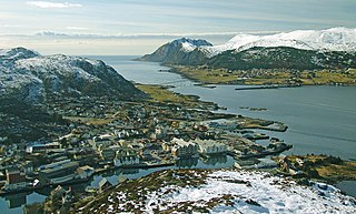
Herøy is a municipality in Møre og Romsdal county, Norway. It is part of the Sunnmøre region. The administrative centre is the town of Fosnavåg on the island of Bergsøya. The industrial area of Eggesbønes is located south of Fosnavåg on the same island. The Runde Environmental Centre is located in the northern part of the municipality on Runde island. Other population centres in Herøy include the villages of Leikong, Kvalsund, or Moltustranda.

<span class="mw-page-title-main">Stordal</span> Former municipality in Norway

Stordal is a former municipality in Møre og Romsdal county, Norway. It merged with Norddal municipality to establish the new Fjord municipality in 2020. It was part of the Sunnmøre region. The administrative centre of the municipality was the village of Stordal. The historic farm and museum of Ytste Skotet lies along the Storfjorden in the western part of the municipality. Most of the municipality lies on the eastern side of the fjord.

<span class="mw-page-title-main">Sykkylven</span> Municipality in Møre og Romsdal, Norway

Sykkylven is a municipality in Møre og Romsdal county, Norway. It is part of the Sunnmøre region. The administrative centre is the village of Aure. Other villages in the municipality include Ikornnes, Straumgjerde, and Tusvik.

<span class="mw-page-title-main">Tresfjord</span> Former municipality in Norway

Tresfjord is former municipality in Møre og Romsdal county, Norway. The municipality existed from 1899 until its dissolution in 1964. It encompassed about 200 square kilometres (77 sq mi) in the southern part of the present-day Vestnes Municipality. The municipality included the Skorgedalen valley and the area surrounding both sides of the southern half of the Tresfjorden. The village of Tresfjord was the administrative centre of the municipality, and it was the location of Tresfjord Church, the main church for the municipality.

<span class="mw-page-title-main">Dalsfjord, Møre og Romsdal</span> Former municipality in Møre og Romsdal, Norway

Dalsfjord is a former municipality in the Sunnmøre region of Møre og Romsdal county, Norway. The former municipality existed from 1924 until its dissolution in 1964. The 165-square-kilometre (64 sq mi) municipality included the area around the Dalsfjorden between Vanylven Municipality in the west and almost all the way to the Kilsfjorden in the east. The area is now a part of Volda Municipality. The administrative centre was the village of Dravlaus. Other villages in the area included Ulvestadbygda, Åmelfot, Steinsvik, and Dalsbygda.

<span class="mw-page-title-main">Hen, Møre og Romsdal</span> Former municipality in Norway

Hen is a former municipality in Møre og Romsdal county, Norway. The 245-square-kilometre (95 sq mi) municipality existed from 1902 until its dissolution in 1964. Hen encompassed the valleys extending to the south and east of the Isfjorden in the northeastern part of the present-day Rauma Municipality. The administrative center of Hen was the village of Isfjorden. The area of Hen Municipality is still a parish within the municipality of Rauma. The parish has one church, Hen Church, located in Isfjorden.

<span class="mw-page-title-main">Brattvær</span> Former municipality in Norway

Brattvær is a former municipality in Møre og Romsdal county, Norway. The 73-square-kilometre (28 sq mi) municipality existed from 1915 until its dissolution in 1960. It was located on the northwestern part of the island of Smøla in the present-day municipality of Smøla. It included the area surrounding the villages of Råket and Dyrnes as well as the surrounding islets. The Brattvær Church was the main church of the municipality.

<span class="mw-page-title-main">Vartdal</span> Former municipality in Møre og Romsdal, Norway

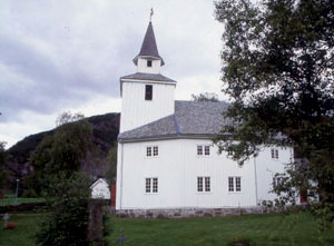
Vartdal is a former municipality in Møre og Romsdal county, Norway. The municipality existed from 1895 until its dissolution in 1965. The 125-square-kilometre (48 sq mi) area now sits in the northwestern part of the Ørsta municipality, along the Vartdalsfjorden. The administrative centre was the village Sætre, which is also known as Vartdal. Other villages in the municipality were Flåskjer and Nordre Vartdal. The main church for Vartdal was Vartdal Church, located in the village of Nordre Vartdal.

<span class="mw-page-title-main">Rovdane</span> Village in Western Norway, Norway

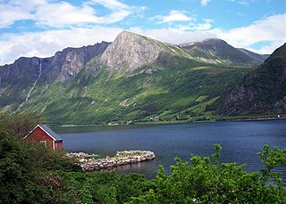
Rovdane or Rovde is a village in Vanylven Municipality in Møre og Romsdal county, Norway. It is located along the Rovdefjorden, about 15 kilometres (9.3 mi) north of the village of Myklebost, 27 kilometres (17 mi) northeast of the municipal center of Fiskåbygd, and 20 kilometres (12 mi) west of the village of Volda. The district around Rovdane is referred to as Rovdestranda. Rovde Church is located in Rovdane.

<span class="mw-page-title-main">Røros landsogn</span> Former municipality in Norway

Røros landsogn is a former municipality in the old Sør-Trøndelag county in Norway. The 729-square-kilometre (281 sq mi) municipality encompassed the southern part of the what is now the municipality of Røros in Trøndelag county. The municipality nearly surrounded the small enclave that was the mining town of Røros and it stretched all the way southeast to the lake Femunden and the Swedish border. The administrative centre of the municipality was located in the town of Røros where Røros Church is located.

<span class="mw-page-title-main">Hylestad</span> Former municipality in Aust-Agder, Norway

Hylestad is a former municipality in the old Aust-Agder county in Norway. The 570-square-kilometre (220 sq mi) former municipality existed from 1915 until its dissolution in 1962. It was located in the southern part of the present-day municipality of Valle in the traditional region of Setesdal in Agder county. The administrative centre was the village of Rysstad where the Hylestad Church was located.

<span class="mw-page-title-main">Syvde</span> Former municipality in Norway

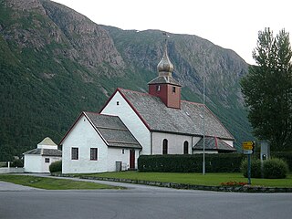
Syvde is a former municipality in Møre og Romsdal county, Norway. The municipality existed from 1918 until its dissolution in 1964. The 125-square-kilometre (48 sq mi) municipality included the areas surrounding the Syvdsfjorden in the eastern part of the present-day Vanylven Municipality. The administrative centre of the municipality was the village of Myklebost, at the end of the fjord. Syvde Church was the municipal church.

<span class="mw-page-title-main">Sør-Aukra</span> Former municipality in Norway

Sør-Aukra is a former municipality in Møre og Romsdal county, Norway. Sør-Aukra Municipality existed from 1924 until 1965 when it was merged into Midsund Municipality. The 86-square-kilometre (33 sq mi) municipality consisted of the entire island of Otrøya, the eastern part of Midøya island, and some small surrounding islands at the entrance to the large Romsdal Fjord. The village of Midsund was the administrative centre of the municipality.

<span class="mw-page-title-main">Sunnylven</span> Former municipality in Norway

Sunnylven is a former municipality in Møre og Romsdal county, Norway. The 637-square-kilometre (246 sq mi) municipality existed from 1838 until its dissolution in 1965. Since that time, it has made up the southern part of the present-day Stranda Municipality. It encompassed the areas around the Sunnylvsfjorden and Geirangerfjorden. The village of Hellesylt was the administrative centre of the municipality and Geiranger was the other main population centre in Sunnylven. The main church for the municipality was Sunnylven Church in Hellesylt.

<span class="mw-page-title-main">Bud (municipality)</span> Former municipality in Norway

Bud is a former municipality in Møre og Romsdal county, Norway. The municipality existed from 1838 until its dissolution in 1964 when it was merged into Fræna Municipality. The 35-square-kilometre (14 sq mi) municipality was centered around the village of Bud which was the administrative centre of the municipality. Bud Church was the main church for the municipality.

<span class="mw-page-title-main">Hustad (municipality)</span> Former municipality in Norway

Hustad is a former municipality in Møre og Romsdal county, Norway. Hustad existed as a municipality from 1918 until its dissolution in 1964 when it was merged into Fræna Municipality. The 125-square-kilometre (48 sq mi) municipality encompassed most of the northern part of the Romsdal Peninsula in what is now Hustadvika Municipality. The administrative centre of the municipality was the village of Hustad where Hustad Church is located.

<span class="mw-page-title-main">Kornstad (municipality)</span> Former municipality in Norway

Kornstad is a former municipality in Møre og Romsdal county, Norway. The municipality existed from 1897 until its dissolution in 1964. The 66-square-kilometre (25 sq mi) municipality encompassed the western part oft the present-day Averøy Municipality on the island of Averøya, plus a small area in the present-day Hustadvika Municipality on the mainland Romsdal Peninsula to the west of the island. The administrative centre of the municipality was the village of Kornstad where Kornstad Church is located.

<span class="mw-page-title-main">Straumsnes (municipality)</span> Former municipality in Norway

Straumsnes is a former municipality in Møre og Romsdal county, Norway. The 124-square-kilometre (48 sq mi) municipality existed from 1866 until its dissolution in 1964. It included the northern part of the Straumsnes peninsula, the eastern part of the island of Aspøya, and several surrounding islands in the northern part of the present-day Tingvoll Municipality. The administrative centre of the municipality was the village of Straumsnes where the Straumsnes Church is located.

References

  1. 1 2 Thorsnæs, Geir, ed. (11 September 2015). "Rovde". Store norske leksikon (in Norwegian). Kunnskapsforlaget . Retrieved 24 August 2019.
  2. Jukvam, Dag (1999). Historisk oversikt over endringer i kommune- og fylkesinndelingen (PDF) (in Norwegian). Statistisk sentralbyrå. ISBN   9788253746845.
  3. Rygh, Oluf (1908). Norske gaardnavne: Romsdals amt (in Norwegian) (13 ed.). Kristiania, Norge: W. C. Fabritius & sønners bogtrikkeri. p. 33.
  4. Hansen, Tore; Vabo, Signy Irene, eds. (20 September 2022). "kommunestyre". Store norske leksikon (in Norwegian). Kunnskapsforlaget . Retrieved 1 January 2023.
  5. "Kommunevalgene og Ordførervalgene 1959" (PDF) (in Norwegian). Oslo: Statistisk sentralbyrå. 1960. Retrieved 20 April 2020.
  6. "Kommunevalgene og Ordførervalgene 1955" (PDF) (in Norwegian). Oslo: Statistisk sentralbyrå. 1957. Retrieved 20 April 2020.
  7. "Kommunevalgene og Ordførervalgene 1951" (PDF) (in Norwegian). Oslo: Statistisk sentralbyrå. 1952. Retrieved 20 April 2020.
  8. "Kommunevalgene og Ordførervalgene 1947" (PDF) (in Norwegian). Oslo: Statistisk sentralbyrå. 1948. Retrieved 20 April 2020.
  9. "Kommunevalgene og Ordførervalgene 1945" (PDF) (in Norwegian). Oslo: Statistisk sentralbyrå. 1947. Retrieved 20 April 2020.
  10. "Kommunevalgene og Ordførervalgene 1937" (PDF) (in Norwegian). Oslo: Statistisk sentralbyrå. 1938. Retrieved 20 April 2020.
  11. Rabben, Bjarne (1979). "Ordførarar 1904–1975". Soga om Sande og Rovde (in Norwegian). Vol. V. Sande sogenemnd. pp. 461–463.