
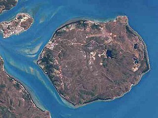
Saibai is a town within the locality of Saibai Island in the Torres Strait Island Region, Queensland, Australia. [1]
Saibai is a town within the locality of Saibai Island in the Torres Strait Island Region, Queensland, Australia. [1]
Kala Kawaw Ya (also known as Kalaw Kawaw, KKY) is one of the languages of the Torres Strait. Kala Kawaw Ya is the traditional language owned by the Top Western islands of the Torres Strait. The Kala Kawaw Ya language region includes the landscape within the local government boundaries of the Torres Shire Council. [2]
It is believed that there was a school on island since about 1900. It was possibly a mission school during the 1930s. [3]
On 29 January 1985 Saibai Island State School opened. In 2007 it became that Saibai Island campus of the Tagai State School which operates in numerous island in the Torres Strait. [3]
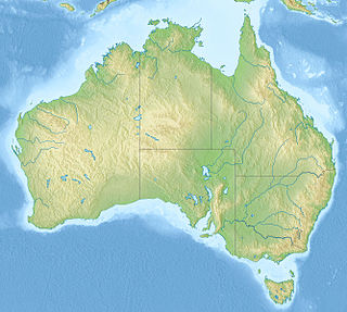
The Torres Strait is a strait between Australia and the Melanesian island of New Guinea. It is 151 km (94 mi) wide at its narrowest extent. To the south is Cape York Peninsula, the northernmost extremity of the Australian mainland. To the north is the Western Province of Papua New Guinea. It is named after the Spanish navigator Luís Vaz de Torres, who sailed through the strait in 1606.
The Torres Strait Islands are a group of at least 274 small islands in Torres Strait, the waterway separating far northern continental Australia's Cape York Peninsula and the island of New Guinea. They span an area of 48,000 km2 (19,000 sq mi), but their total land area is 566 km2 (219 sq mi).

Torres Strait Islanders are the Indigenous peoples of the Torres Strait Islands, which are part of the state of Queensland, Australia. Ethnically distinct from the Aboriginal people of the rest of Australia, they are often grouped with them as Indigenous Australians. Today there are many more Torres Strait Islander people living in mainland Australia than on the Islands.

Thursday Island, colloquially known as TI, or in the Kawrareg dialect, Waiben or Waibene, is an island of the Torres Strait Islands, an archipelago of at least 274 small islands in the Torres Strait. TI is located approximately 39 kilometres north of Cape York Peninsula in Far North Queensland, Australia. Thursday Island is also the name of the town in the south and west of the island and also the name of the locality which contains the island within the Shire of Torres. The town of Rose Hill is located on the north-eastern tip of the island.
The Mabuiag, or Mabuygiwgal, are an Indigenous Australian group of Torres Strait Islander people united by a common language, strong ties of kinship and survived as skilled hunter–fisher–gatherers in family groups or clans living on a number of Torres Strait Islands including Mabuiag Island, in the Torres Strait in Queensland, Australia. They are ethnically Melanesian.

Boigu Island is the most northerly inhabited island of Queensland and of Australia. It is part of the top-western group of the Torres Strait Islands, which lie in the Torres Strait separating Cape York Peninsula from the island of New Guinea. The mainland of Papua New Guinea is only 6 kilometres (3.7 mi) away from Boigu. Boigu has an area of 89.6 square kilometres (34.6 sq mi). Boigu is also the name of the town and Boigu Island is the name of the locality on the island within the Torres Strait Island Region.
Horn Island, or Ngurupai/Narupai in the local language, is an island of the Torres Strait Islands archipelago located in the Torres Strait, in Queensland in Northern Australia between the Australian mainland and Papua New Guinea. It is within the locality of Horn within the Shire of Torres. The town of Wasaga is on the north-western coast of the island. In the 2016 census, the locality of Horn had a population of 531 people.

Mabuiag is one of the Torres Strait Islands in Queensland, Australia. Mabuiag Island is also a town and locality in the Torres Strait Island Region local government area. In the 2016 census, Mabuiag Island had a population of 210 people.
Saibai Island is an island of the Torres Strait Islands archipelago, located in the Torres Strait of Queensland, Australia. The island is situated north of the Australian mainland and south of the island of New Guinea. The island is a locality within the Torres Strait Island Region local government area. The town of Saibai is located on the north-west coast of the island. In the 2016 census, Saibai Island had a population of 465 people.

Bamaga is a small town and locality about 40 kilometres (25 mi) from the northern tip of Cape York in the north of Queensland, Australia. It is within the Northern Peninsula Area Region. It is one of the northernmost settlements in continental Australia and is the administrative centre for the Northern Peninsula Area Regional Council.

Seisia is a coastal town and a locality in the Northern Peninsula Area Region, Queensland, Australia. In the 2016 census, Seisia had a population of 260 people.

The Prince of Wales Island, or Muralag, is an island of the Torres Strait Islands archipelago at the tip of Cape York Peninsula within the Endeavour Strait of Torres Strait in Queensland, Australia. The island is situated approximately 20 km (12 mi) north of Muttee Heads which is adjacent to Bamaga and south of Thursday Island. It is within the locality of Prince Of Wales within the Shire of Torres. In the 2016 census, the locality had a population of 109 people.

Moa Island, also called Banks Island, is an island of the Torres Strait Islands archipelago that is located 40 kilometres (25 mi) north of Thursday Island in the Banks Channel of Torres Strait, Queensland, Australia. It is also a locality within the Torres Strait Island Region local government area. This island is the largest within the "Near Western" group. It has two towns, Kubin on the south-west coast and St Pauls on the east coast, which are connected by bitumen and a gravel road. In the 2016 census, Moa Island had a population of 448 people.

Badu or Badu Island, pronounced ['ba:du:] in English, in Kala Lagaw Ya Badhu [bad̪u], is an island in the Torres Strait 60 kilometres (37 mi) north of Thursday Island, Queensland, Australia. Badu Island is also a locality in the Torres Strait Island Region, and Wakaid is the only town, located on the south-east coast. This island is one of the Torres Strait Islands. The language of Badu is Kala Lagaw Ya.

Coconut Island, Poruma Island, or Puruma in the local language, is an island in the Great North East Channel near Cumberland Passage, Torres Strait, Queensland, Australia. One of the Torres Strait Islands, Coconut Island is 130 kilometres (81 mi) northeast of Thursday Island. Administratively, Coconut Island is a town and Poruma Island is the locality within the Shire of Torres.

Yam Island, called Yama or Iama in the Kulkalgau Ya language or Turtle-backed Island in English, is an island of the Bourke Isles group of the Torres Strait Islands, located in the Tancred Passage of the Torres Strait in Queensland, Australia. The island is situated approximately 100 kilometres (62 mi) northeast of Thursday Island and measures about 2 square kilometres (0.77 sq mi). In the 2016 census, Iama Island had a population of 319 people.

The Shire of Cook is a local government area in Far North Queensland, Australia. The Shire covers most of the eastern and central parts of Cape York Peninsula, the most northerly section of the Australian mainland.

Holy Trinity Church is a heritage-listed Anglican church at Saibai Island, Torres Strait Island Region, Queensland, Australia. It was built from 1926 to 1938. It is also known as Holy Trinity Church of England. It was added to the Queensland Heritage Register on 21 October 1992.

All Saints Anglican Church is a heritage-listed church at Darnley Island, Torres Strait Island Region, Queensland, Australia. It was built from 1919 to 1938. It was added to the Queensland Heritage Register on 21 October 1992.

Dauan Island is an island in the Torres Strait, Queensland, Australia; it is also known as Cornwallis Island. Dauan is also gazetted as a town and a locality in the Torres Strait Island Region local government area.