
Thursday Island, colloquially known as TI, or in the Kawrareg dialect, Waiben or Waibene, is an island of the Torres Strait Islands, an archipelago of at least 274 small islands in the Torres Strait. TI is located approximately 39 kilometres north of Cape York Peninsula in Far North Queensland, Australia.

Boigu Island is the most northerly inhabited island of Queensland and of Australia. It is part of the Top Western group of the Torres Strait Islands, which lie in the Torres Strait separating Cape York Peninsula from the island of New Guinea. The mainland of Papua New Guinea is only 6 kilometres (3.7 mi) away from Boigu. Boigu has an area of 89.6 square kilometres (34.6 sq mi). Boigu Island is the name of the locality on the island within the Torres Strait Island Region. Boigu is predominantly inhabited by indigenous Torres Strait Islanders. In the 2021 census, the population of the island was 199, of whom 189 people or 95% of the population identified as Indigenous Australians.
Horn Island, or Ngurupai/Narupai in the local language, is an island of the Torres Strait Islands archipelago located in the Torres Strait, in Queensland in Northern Australia between the Australian mainland and Papua New Guinea. It is within the locality of Horn within the Shire of Torres; the boundaries of the locality include the island itself and surrounding waters of the Torres Strait. The town of Wasaga is on the north-western coast of the island. In the 2021 census, the locality of Horn had a population of 533 people.

Mabuiag, also known as "Mabuyag" and natively "Mabuyaagi", formerly "Jervis Island") is one of the Torres Strait Islands in Queensland, Australia. Mabuiag is also a town and locality in the Torres Strait Island Region local government area. In the 2021 census, the locality of Mabuiag Island had a population of 253 people.

Saibai Island, commonly called Saibai, is an island of the Torres Strait Islands archipelago, located in the Torres Strait of Queensland, Australia. The island is situated north of the Australian mainland and south of the island of New Guinea. The island is a locality within the Torres Strait Island Region local government area. The town of Saibai is located on the north-west coast of the island. According to the 2016 census, Saibai Island had a population of 465 people.

Bamaga is a small town and locality about 40 kilometres (25 mi) from the northern tip of Cape York in the north of Queensland, Australia. It is within the Northern Peninsula Area Region. It is one of the northernmost settlements in continental Australia and is the administrative centre for the Northern Peninsula Area Regional Council.

Seisia is a coastal town and a locality in the Northern Peninsula Area Region, Queensland, Australia. In the 2021 census, the locality of Seisia had a population of 293 people.

Mapoon is a coastal town in the Aboriginal Shire of Mapoon and a locality split between the Aboriginal Shire of Mapoon and the Shire of Cook in Queensland, Australia. In the 2016 census, Mapoon had a population of 317 people.

The Prince of Wales Island, or Muralag, is an island of the Torres Strait Islands archipelago at the tip of Cape York Peninsula within the Endeavour Strait of Torres Strait in Queensland, Australia. The island is situated approximately 20 km (12 mi) north of Muttee Heads which is adjacent to Bamaga and south of Thursday Island. It is within the locality of Prince Of Wales within the Shire of Torres. In the 2021 census, Prince Of Wales had a population of 62 people.
Hammond Island is an island with a town of the same name, in the Torres Strait, Queensland, Australia. It is the only island within the locality of Keriri Island within the local government area of Torres Strait Island Region.

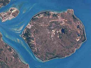
Moa Island, also called Banks Island, is an island of the Torres Strait Islands archipelago that is located 40 kilometres (25 mi) north of Thursday Island in the Banks Channel of Torres Strait, Queensland, Australia. It is also a locality within the Torres Strait Island Region local government area. This island is the largest within the "Near Western" group. It has two towns, Kubin on the south-west coast and St Pauls on the east coast, which are connected by bitumen and a gravel road. In the 2016 census, Moa Island had a population of 448 people.

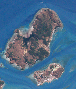
Yam Island, called Yama or Iama in the Kulkalgau Ya language or Turtle-backed Island in English, is an island of the Bourke Isles group of the Torres Strait Islands, located in the Tancred Passage of the Torres Strait in Queensland, Australia. The island is situated approximately 100 kilometres (62 mi) northeast of Thursday Island and measures about 2 square kilometres (0.77 sq mi). The island is an official locality known as Iama Island within the local government area of Torres Strait Island Region. The town, also called Yam Island, is located on the north-west coast of the island. In the 2021 census, Iama Island had a population of 275 people.
Darnley Island or Erub in the native Papuan language, Meriam Mir, is an island formed by volcanic action and situated in the eastern section of the Torres Strait, Queensland, Australia. It is one of the Torres Strait Islands and is located near the Great Barrier Reef and just south of the Bligh entrance. The town on the island is also called Darnley, but the locality is called Erub Island, both being within the local government area of Torres Strait Island Region. In the 2016 census, Erub Island had a population of 328 people.

The Shire of Torres is a local government area located in Far North Queensland, Australia, covering large sections of the Torres Strait Islands and the northern tip of Cape York Peninsula north of 11°S latitude. It holds two distinctions—it is the northernmost Local Government Area in Australia, and is the only one to abut an international border – it is at one point just 73 kilometres (45 mi) from Papua New Guinea. It is administered from Thursday Island.
The Torres Strait Island Region is a local government area in Far North Queensland, Australia, covering part of the Torres Strait Islands. It was created in March 2008 out of 15 autonomous Island Councils during a period of statewide local government reform. It has offices in each of its 15 communities, and satellite services in Thursday Island and in Cairns.

Our Lady of the Sacred Heart Church is a heritage-listed Roman Catholic church at 120 Douglas Street, Thursday Island, Shire of Torres, Queensland, Australia. It was built from c. 1885 to c. 1905. It was added to the Queensland Heritage Register on 7 December 1998.
Umagico is a town and coastal locality in the Northern Peninsula Area Region, Queensland, Australia. In the 2021 census, the locality of Umagico had a population of 394 people.

Dauan Island is an island in the Torres Strait, Queensland, Australia; it is also known as Cornwallis Island. Dauan Island is also a town and locality in the Torres Strait Island Region, Queensland, Australia.

Masig Island is an island and locality in the Torres Strait Island Region, Queensland, Australia. In the 2021 census, Masig Island had a population of 283 people.
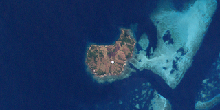
Warraber Islet is an island locality in the Torres Strait Island Region, Queensland, Australia. It consists of a single island, Sue Islet, the middle island of The Three Sisters. The only town is Sue Island on the north-west part of the island. In the 2016 census, Warraber Islet had a population of 245 people.

