
The Santa Susana Pass, originally Simi Pass, is a low mountain pass in the Simi Hills of Southern California, connecting the San Fernando Valley and town of Chatsworth, to the city of Simi Valley and eponymous valley.

Boreas Pass, elevation 11,481 ft (3,499 m), is a high mountain pass in the Rocky Mountains of central Colorado in the United States. The pass is located on the continental divide, at the crest of the Front Range along the border between Park (south) and Summit counties.

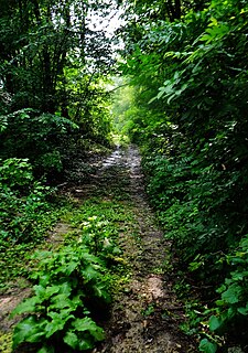
Savanna Portage State Park is a state park of Minnesota, USA, established in 1961 to preserve the historic Savanna Portage, a difficult 6-mile (9.7 km) trail connecting the watersheds of the Mississippi River and Lake Superior. The park contains a drainage divide separating the West Savanna River, which drains to the Mississippi River and the Gulf of Mexico, from the East Savanna River, which flows in an opposite direction to the Saint Louis River, Lake Superior and the Great Lakes, and the Saint Lawrence River to the Atlantic Ocean.

Interstate Park comprises two adjacent state parks on the Minnesota–Wisconsin border, both named Interstate State Park. They straddle the Dalles of the St. Croix River, a deep basalt gorge with glacial potholes and other rock formations. The Wisconsin park is 1,330 acres (538 ha) and the Minnesota park is 298 acres (121 ha). The towns of Taylors Falls, Minnesota and St. Croix Falls, Wisconsin are adjacent to the park. Interstate Park is within the Saint Croix National Scenic Riverway and the Ice Age National Scientific Reserve. The western terminus of the Ice Age National Scenic Trail is on the Wisconsin side. On the Minnesota side, two areas contain National Park Service rustic style buildings and structures that are listed on the National Register of Historic Places.

St. Croix State Park is a state park in Pine County, Minnesota, USA. The park follows the shore of the St. Croix River for 21 miles (34 km) and contains the last 7 miles (11 km) of the Kettle River. At 33,895 acres (13,717 ha) it is the largest Minnesota state park. It was developed as a Recreational Demonstration Area in the 1930s, and is one of the finest surviving properties of this type in the nation. 164 structures built by the Civilian Conservation Corps and the Works Progress Administration survive, the largest collection of New Deal projects in Minnesota. As a historic district they were listed on the National Register of Historic Places and proclaimed a National Historic Landmark in 1997.
The Red River Trails were a network of ox cart routes connecting the Red River Colony and Fort Garry in British North America with the head of navigation on the Mississippi River in the United States. These trade routes ran from the location of present-day Winnipeg in the Canadian province of Manitoba across the Canada–United States border, and thence by a variety of routes through what is now the eastern part of North Dakota and western and central Minnesota to Mendota and Saint Paul, Minnesota on the Mississippi.

The Sorlie Memorial Bridge, also known as the Red River Bridge was built in 1929 by the Minneapolis Bridge Company to connect the cities of Grand Forks, North Dakota and East Grand Forks, Minnesota. It was placed on the National Register of Historic Places in 1999.
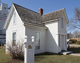
The Dr. William W. Mayo House, located at 118 North Main Street in Le Sueur, Minnesota, United States, is listed on the National Register of Historic Places (NRHP). It was built in 1859 by James Mayo and his brother, William Worrall Mayo who emigrated from Salford, United Kingdom, to the United States in 1846 and became a doctor. William's older son, William James Mayo was born in the home in 1861. William W. Mayo aided pioneers and their families during the Dakota War of 1862 and later moved to Rochester where he became the examining surgeon for the southern Minnesota Civil War draft board. He and his sons, William and Charles founded the 27-bed Saint Marys Hospital which opened in 1889 following the 1883 Rochester tornado. They later founded their namesake, the Mayo Clinic.

The Old Santa Susana Stage Road, or Santa Susana Wagon Road, is a route taken by early travelers between the San Fernando Valley and Simi Valley near Chatsworth, California, via the Santa Susana Pass. The main route climbs through what is now the Santa Susana Pass State Historic Park, with a branch in Chatsworth Park South.

This is a list of the National Register of Historic Places listings in Fillmore County, Minnesota. It is intended to be a complete list of the properties and districts on the National Register of Historic Places in Fillmore County, Minnesota, United States. The locations of National Register properties and districts for which the latitude and longitude coordinates are included below, may be seen in an online map.

The historical buildings and structures of Zion National Park represent a variety of buildings, interpretive structures, signs and infrastructure associated with the National Park Service's operations in Zion National Park, Utah. Structures vary in size and scale from the Zion Lodge to road culverts and curbs, nearly all of which were designed using native materials and regional construction techniques in an adapted version of the National Park Service Rustic style. A number of the larger structures were designed by Gilbert Stanley Underwood, while many of the smaller structures were designed or coordinated with the National Park Service Branch of Plans and Designs. The bulk of the historic structures date to the 1920s and 1930s. Most of the structures of the 1930s were built using Civilian Conservation Corps labor.

The Crown Point Road, or the Crown Point Military Road, is a historic road built in 1759-60, mostly in what is now the United States state of Vermont. It was built by British Army and colonial militia forces to connect Fort Crown Point near the southern end of Lake Champlain to the Fort at Number 4 in what is now Charlestown, New Hampshire. It was the first major road in Vermont, spurring development along its route after the French and Indian War. Fragments of the road are still visible in largely period condition, or have been paved over, while others have disappeared into the forest. Sections of the road located in Weathersfield have been listed on the National Register of Historic Places.

The Grand Ditch, also known as the Grand River Ditch and originally known as the North Grand River Ditch, is a water diversion project in the Never Summer Mountains, in northern Colorado. It is 14.3 miles (23.0 km) long, 20 feet (6.1 m) wide, and 3 feet (0.91 m) deep on average. Streams and creeks that flow from the highest peaks of the Never Summer Mountains are diverted into the ditch, which flows over the Continental Divide at La Poudre Pass at 10,175 feet (3,101 m), delivering the water into Long Draw Reservoir and the Cache La Poudre River for eastern plains farmers. The ditch was started in 1890 and wasn't completed until 1936. The ditch diverts between 20 and 40% of the runoff from the Never Summer Mountains, and delivers an average of 20,000 acre feet (25,000,000 m3). It significantly impacts the ecology in the valley below and the National Park Service has fought in court to reduce the amount of diverted water.
This is a list of the National Register of Historic Places listings in Dodge County, Minnesota. It is intended to be a complete list of the properties and districts on the National Register of Historic Places in Dodge County, Minnesota, United States. The locations of National Register properties and districts for which the latitude and longitude coordinates are included below, may be seen in an online map.

The Mendota to Wabasha Military Road, Cannon River Section is a 3,200-foot-long (980 m) fragment of a road in Red Wing in the U.S. state of Minnesota. The road once stretched from Mendota to Wabasha and was planned in the earliest years of Minnesota Territory before Minnesota became a state. This particular fragment of road, which spans the Cannon River bottomlands, was listed on the National Register of Historic Places in 1991. It was listed as part of a statewide survey that identified historic fragments of the military wagon roads built between 1850 and 1861. The survey found that a road fragment could be considered historic if it was unpaved, that it is "long enough to evoke a sense of destination" where an observer at one end could not see the other end, and that the setting of the road had not been intruded upon with recent buildings or roads.
The Evergreens is a campground on Ferry Street in Solon, Maine, on the banks of the Kennebec River. The property has a documented archaeological history, with evidence of human habitation dating back thousands of years. It is also known that the military expedition of Benedict Arnold camped in this area in 1775 while en route to Quebec City in the American Revolutionary War. The property has had formal excavations by the Maine State Museum, and was listed on the National Register of Historic Places in 1982.
Réaume's Trading Post was a trading post established on the Leaf River in 1792 in what is now Wing River Township, Minnesota, United States. No visible traces remain at the site, which is on private property, but archaeological investigations have identified several features. It was listed on the National Register of Historic Places in 1974 for having state-level significance in the themes of commerce and historical archaeology. It was nominated for its role in and research potential on the opening of the fur trade in north-central Minnesota.
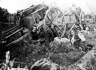
The Minnesota Stage Company was the largest stagecoach company based in Minnesota, United States. It was established in 1859 in a merger of J.C. Burbank & Company and Chase & Allen, at which point it controlled all the major stagecoach lines in the state. In the years before railroads linked Minnesota communities, the Minnesota Stage Company played a crucial role in shaping the commercial and social life of the young state.
The Lake City and Rochester Stage Road was an early road between Lake City and Rochester, Minnesota, United States. It was blazed in 1858 to carry stagecoach traffic between the Mississippi River port and a major inland town in southeast Minnesota.


